Skip to main content
Main navigation
Finding Aids
Digital Projects
African American Experience in Las Vegas
Charles Saladino Landscape Architecture Collection
Culinary Union Photograph Collection
Dino at the Sands
Dreaming the Skyline
Entertainment
Historic Landscape of Nevada
Hoover Dam
Jamey Stillings
Menus: The Art of Dining
Nevada Test Site Oral History Project
Newspapers
Oral Histories Collection
Photograph Collections
Rebel Yell Newspaper
Showgirls
Southern Nevada: The Boomtown Years 1900-1925
Southern Nevada History in Maps
Southern Nevada Jewish Heritage Project
UNLV CSUN Records
Union Pacific Railroad Water Documents
Walking Box Ranch Collection
Welcome Home Howard
About
Request Images
Help
Provide Feedback
Special Collections Home
Search the Special Collections and Archives Portal
Search
Search
Breadcrumb
Home
Still Image
A static visual representation
Authority Sources
DCMI Type Vocabulary
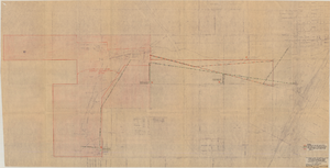
Map showing proposed relocation or removal of existing water transmission mains and power lines at Las Vegas, Nevada, June 3, 1952, copy 2
Image
View
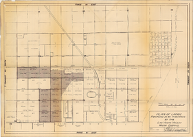
Plan of lands proposed to be purchased by the Las Vegas Valley Water District, August 1, 1952
Image
View
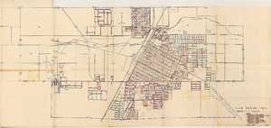
Map showing various facilities of the Las Vegas Land and Water Company, March 1, 1953
Image
View
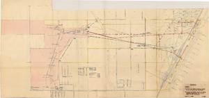
Map showing location of water-bearing lands to be sold to the Las Vegas Valley Water District, March 1, 1953
Image
View
Plan of proposed new well pipe and fittings for Las Vegas, Nevada, 1936
Image
View
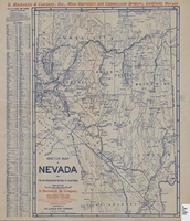
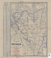
Sketch map of Nevada and the southeastern portion of California, 1906
Image
View
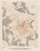
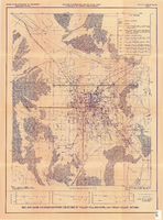
Map of well locations, Las Vegas Valley, Nevada, 1975
Image
View
Geologic map of Las Vegas Valley, Nevada, 1982
Image
View
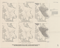
Maps showing distribution of coarse- and fine-grained deposits in the upper 1,000 feet of valley fill, Las Vegas Valley, Nevada, 1981 (Water-supply paper 2320-A, plate 3)
Image
View
Index map showing locations of geologic sections on plate 2 and wells on plates 2 and 3, Las Vegas Valley, Nevada, 1981 (Water-supply paper 2320-A)
Image
View
Map and basin profiles showing thickness of valley-fill deposits, Las Vegas Valley, Nevada, 1981
Image
View
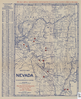
Sketch map of Nevada and the southeastern portion of California, 1906
Image
View
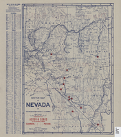
Sketch map of Nevada and the southeastern portion of California, 1906
Image
View
Sketch map of Nevada and the southeastern portion of California, 1906
Image
View
Map showing general geology and areas of artesian flow of the Las Vegas, Pahrump, and Indian Spring Valleys, Clark and Nye Counties, Nevada, 1946
Image
View
Map showing configuration of potentiometric surfaces in Paleozoic and Cenozoic aquifers in the area between the Las Vegas Valley and the Amargosa Desert, Nevada, 1963
Image
View
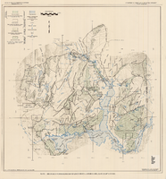
Generalized hydrogeologic map of lower Moapa-Lake Mead area, Clark County, Nevada, 1968
Image
View
Map of the Nevada Test Site and vicinity showing principal rock types and chemistry of ground water, 1964
Image
View
Pagination
First page
« First
Previous page
‹‹
…
Page
2132
Page
2133
Page
2134
Page
2135
Current page
2136
Page
2137
Page
2138
Page
2139
Page
2140
…
Next page
››
Last page
Last »