Skip to main content
Main navigation
Finding Aids
Digital Projects
African American Experience in Las Vegas
Charles Saladino Landscape Architecture Collection
Culinary Union Photograph Collection
Dino at the Sands
Dreaming the Skyline
Entertainment
Historic Landscape of Nevada
Hoover Dam
Jamey Stillings
Menus: The Art of Dining
Nevada Test Site Oral History Project
Newspapers
Oral Histories Collection
Photograph Collections
Rebel Yell Newspaper
Showgirls
Southern Nevada: The Boomtown Years 1900-1925
Southern Nevada History in Maps
Southern Nevada Jewish Heritage Project
UNLV CSUN Records
Union Pacific Railroad Water Documents
Walking Box Ranch Collection
Welcome Home Howard
About
Request Images
Help
Provide Feedback
Special Collections Home
Search the Special Collections and Archives Portal
Search
Search
Breadcrumb
Home
Still Image
A static visual representation
Authority Sources
DCMI Type Vocabulary
Topographic map of Nevada-California, Las Vegas quadrangle, 1951
Image
View
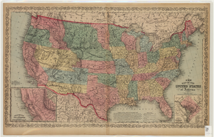
Map of the United States of America, 1859
Image
View
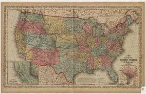
Map of the United States of America, 1856
Image
View
Original plat, townsite of Las Vegas, Lincoln Co., Nevada, January 13, 1905
Image
View
Map showing parts of eastern and southeastern Nevada and southwestern Utah, circa 1873
Image
View
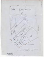
Plat showing cultivated land in the Stewart Ranch, Las Vegas, Nevada, December 8, 1902
Image
View
Plat showing original townsite and subdivisions, Las Vegas, Lincoln County, Nevada, May 1905
Image
View
Blueprint showing proposed pipeline for gravity water supply at Las Vegas, Nevada, February 16, 1905
Image
View
Map showing second stage plan of development for Southern Nevada Water Project, March 1981
Image
View
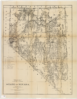
Map of Nevada, 1876
Image
View
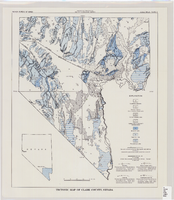
Tectonic map of Clark County, Nevada, 1965
Image
View
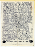
Map showing Tonopah & Tidewater Railroad Company line from Ludlow, California to Goldfield, Nevada, circa 1907
Image
View
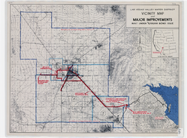
Map showing improvements made to the Las Vegas Valley Water District and vicinity under $8,700,000 bond issue,circa 1957
Image
View
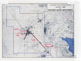
Map showing improvements made to the Las Vegas Valley Water District and vicinity, circa 1950
Image
View
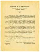
Map of Clark's Las Vegas Townsite, Lincoln County, Nevada, May 10, 1905
Text
View
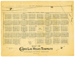
Map of Clark's Las Vegas Townsite, Lincoln County, Nevada, May 10, 1905, side 1
Image
View
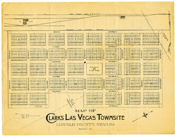
Map of Clark's Las Vegas Townsite, Lincoln County, Nevada, May 10, 1905, side 2
Image
View
Map of California, and territories of Utah, Nevada, Colorado, New Mexico and Arizona, 1864
Text
View
Pagination
First page
« First
Previous page
‹‹
…
Page
2122
Page
2123
Page
2124
Page
2125
Current page
2126
Page
2127
Page
2128
Page
2129
Page
2130
…
Next page
››
Last page
Last »