Search Results
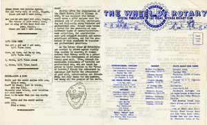
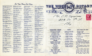
The Wheel of Rotary Las Vegas Rotary Club newsletter, August 18, 1949
Date
Archival Collection
Description
Text
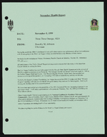
Alpha Kappa Alpha Sorority, Theta Theta Omega Chapter health committee report
Date
Archival Collection
Description
From the Alpha Kappa Alpha Sorority, Incorporated, Theta Theta Omega Chapter Records (MS-01014) -- Chapter records file.
Text
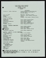
Alpha Kappa Alpha Sorority, Theta Theta Omega Chapter chapter meeting agenda
Date
Archival Collection
Description
From the Alpha Kappa Alpha Sorority, Incorporated, Theta Theta Omega Chapter Records (MS-01014) -- Chapter records file.
Text
The Wheel of Rotary Las Vegas Rotary Club newsletter, March 30, 1950
Date
Archival Collection
Description
Text
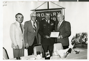
Photograph of members of the Las Vegas, Nevada Rotary Club, March 14, 1982
Date
Archival Collection
Description
L-R: Former Las Vegas Rotary Club President Angelo Manzi, North Las Vegas Mayor Bud Cleland, Colonel Hupp and Las Vegas newspaper journalist and editor John Cahlan. The two men on the right are holding a certificate of appreciation celebrating the fiftieth anniversary of the Rotay Club in Las Vegas.
Image
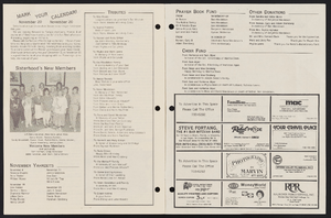
Newsletter from Congregation Ner Tamid (Las Vegas, Nev.), November 1988
Date
Archival Collection
Description
Congregation Ner Tamid's bulletin for November 1988. The bulletin contains pictures, notes, and news.
Mixed Content
Christie Young Papers
Identifier
Abstract
The Christie Young Papers are comprised of Young's personal papers and journals between 1982 and 2011. These journals document Young's arrival to Las Vegas, Nevada and her involvement in several nascent Las Vegas lesbian, gay, bisexual, transgender, and queer (LGBTQ) organizations from 1982 to 1985 such as UNLV's Lesbian and Gay Academic Union (LGAU). The collection also includes materials related to her life in San Diego from 1985 to 1995. The collection also includes typed transcripts of all journal entries that relate to the Las Vegas LGBTQ community.
Archival Collection
Archaeo-Nevada Society Records
Identifier
Abstract
The Archaeo-Nevada Society Records (1930-2016) consist of archaeological and conservation articles, correspondence, brochures, newsletters, programs, maps, and information about the flora and fauna of Nevada. Materials also include scrapbooks and photograph albums detailing the activities of the society between 1966 and 1999.
Archival Collection
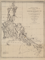
Map of explorations and surveys south of the Central Pacific Railroad made by the U.S. Army Corps of Topographical Engineers, 1871
Date
Description
Image