Skip to main content
Main navigation
Finding Aids
Digital Projects
African American Experience in Las Vegas
Charles Saladino Landscape Architecture Collection
Culinary Union Photograph Collection
Dino at the Sands
Dreaming the Skyline
Entertainment
Historic Landscape of Nevada
Hoover Dam
Jamey Stillings
Menus: The Art of Dining
Nevada Test Site Oral History Project
Newspapers
Oral Histories Collection
Photograph Collections
Rebel Yell Newspaper
Showgirls
Southern Nevada: The Boomtown Years 1900-1925
Southern Nevada History in Maps
Southern Nevada Jewish Heritage Project
UNLV CSUN Records
Union Pacific Railroad Water Documents
Walking Box Ranch Collection
Welcome Home Howard
About
Request Images
Help
Provide Feedback
Special Collections Home
Search the Special Collections and Archives Portal
Search
Search
Breadcrumb
Home
Still Image
A static visual representation
Authority Sources
DCMI Type Vocabulary
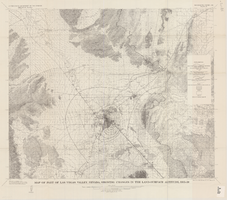
Map of part of Las Vegas Valley, Nevada, showing changes in the land-surface altitude, 1935-50
Image
View
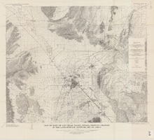
Map of part of Las Vegas Valley, Nevada, showing changes in the land-surface altitude, 1935 to 1940-41
Image
View
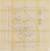
Map showing estimated average recharge to and discharge from ground-water reservoirs by basins, and hydraulic potential in Clark and Nye counties, Nevada, 1963
Image
View
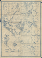
Official road map of the State of Nevada, 1941
Image
View
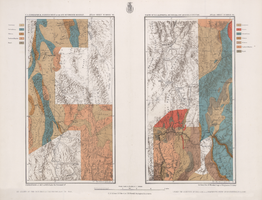
Maps of geographical surveys of parts of California, southeastern Nevada, Arizona and southwestern Utah, made under the command of George M. Wheeler, 1872-1873
Image
View
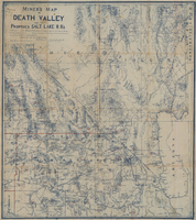
Miners map of Death Valley and the proposed Salt Lake railroads, January 1903
Image
View
General highway base map, state of Nevada, 1975
Image
View
Map of Las Vegas, Nevada and surrounding Bureau of Land Management areas to the west and north, 1994
Text
View
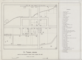
Map of St. Thomas, Nevada, circa 1933
Image
View
Map of Las Vegas Valley, Clark County, Nevada, October 1, 1940
Image
View
Map of the Livingston Ranches near Overton, Clark County, Nevada, March 27, 1920
Image
View
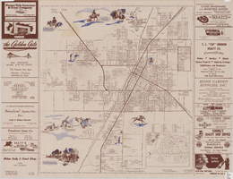
Official Arrow city map, Las Vegas & vicinity, Nevada, circa 1957-1961
Image
View
Map of Las Vegas and vicinity, Nevada, circa 1957-1961
Image
View
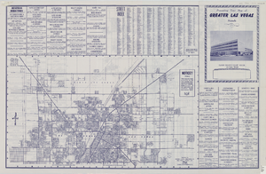
Street map of greater Las Vegas, 1963
Image
View
Map of Las Vegas and vicinity, including Henderson and Boulder City, Nevada, 1958
Image
View
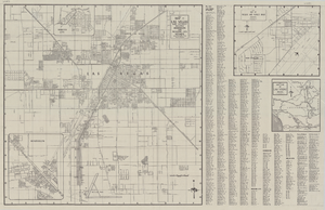
Map of the city of Las Vegas, North Las Vegas, and the "Strip", 1956
Image
View
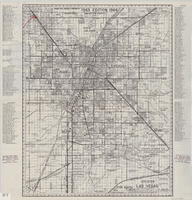
Street map of greater Las Vegas, Nevada, circa 1965-1968
Image
View
Geologic map of the Paiute Ridge quadrangle, Nye and Lincoln Counties, Nevada, 1967
Image
View
Pagination
First page
« First
Previous page
‹‹
…
Page
2140
Page
2141
Page
2142
Page
2143
Current page
2144
Page
2145
Page
2146
Page
2147
Page
2148
…
Next page
››
Last page
Last »