Skip to main content
Main navigation
Finding Aids
Digital Projects
African American Experience in Las Vegas
Charles Saladino Landscape Architecture Collection
Culinary Union Photograph Collection
Dino at the Sands
Dreaming the Skyline
Entertainment
Historic Landscape of Nevada
Hoover Dam
Jamey Stillings
Menus: The Art of Dining
Nevada Test Site Oral History Project
Newspapers
Oral Histories Collection
Photograph Collections
Rebel Yell Newspaper
Showgirls
Southern Nevada: The Boomtown Years 1900-1925
Southern Nevada History in Maps
Southern Nevada Jewish Heritage Project
UNLV CSUN Records
Union Pacific Railroad Water Documents
Walking Box Ranch Collection
Welcome Home Howard
About
Request Images
Help
Provide Feedback
Special Collections Home
Search the Special Collections and Archives Portal
Search
Search
Breadcrumb
Special Collections and Archives Portal
Image
A visual representation other than text
Authority Sources
DCMI Type Vocabulary
Aerial photograph of Lake Powell's Halls Crossing Marina, looking east in Utah: digital photograph
Image
View
Aerial photograph of Lake Powell's Cathedral Canyon area in Utah: digital photograph
Image
View
Aerial photograph of shoreline in Lake Powell's Dangling Rope area in Utah: digital photograph
Image
View
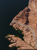
Aerial photograph of Gregory Butte on Lake Powell looking northeast up Last Chance Bay in Utah: digital photograph
Image
View
Aerial photograph of shoreline near Lake Powell's Last Chance Bay in Utah: digital photograph
Image
View
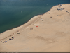
Aerial photograph of campers on Lone Rock Beak along Lake Powell's Wahweap Bay in Utah: digital photograph
Image
View
Aerial photograph of a landlocked Lone Rock in Lake Powell's Wahweap Bay, looking west in Utah: digital photograph
Image
View
Aerial photograph of an overlook on Wahweap Bay in Utah: digital photograph
Image
View
Aerial photograph of Glen Canyon Dam from upstream showing Paige, Arizona looking southeast: digital photograph
Image
View
Aerial photograph of mountains along Lake Powell's Gunsight Bay, looking west in Utah: digital photograph
Image
View
Aerial photograph of shoreline sculpted by receding water lines on Lake Powell near Padre Bay: digital photograph
Image
View
Aerial photograph of a houseboat moored along a shoreline north of Padre Bay in Utah: digital photograph
Image
View
Aerial photograph looking north towards Padre Bay in Utah, as seen from Arizona: digital photograph
Image
View
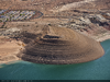
Aerial photograph of geographic formations revealed by receding water levels at Lake Powell looking west from near Antelope Island: digital photograph
Image
View
Aerial photograph of power lines running from the Glen Canyon Dam in Arizona: digital photograph
Image
View
Aerial photograph of the Glen Canyon Dam looking north from below the dam in Arizona: digital photograph
Image
View
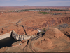
Aerial photograph of the Glen Canyon Dam and power infrastructure, looking east in Arizona: digital photograph
Image
View
Aerial photograph of the Colorado River near Horseshoe Bend south of Lake Powell, looking north in Arizona: digital photograph
Image
View
Pagination
First page
« First
Previous page
‹‹
…
Page
18
Page
19
Page
20
Page
21
Current page
22
Page
23
Page
24
Page
25
Page
26
…
Next page
››
Last page
Last »