Search Results

Topographic map of groundwater in the southwest quadrangle of Las Vegas, Nevada, 1985
Date
Description
Text

Topographic map of groundwater in the southeast quadrangle of Las Vegas, Nevada, 1980
Date
Description
Text

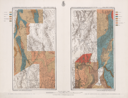
Map showing parts of eastern and southeastern Nevada and southwestern Utah, circa 1873
Date
Archival Collection
Description
Image
Maps of geographical surveys of parts of California, southeastern Nevada, Arizona and southwestern Utah, made under the command of George M. Wheeler, 1872-1873
Date
Description
Image
Association of Women in Science, Las Vegas Chapter Records
Identifier
Abstract
The Association of Women in Science, Las Vegas, Nevada Chapter Records date from 1976 to 1999 and cover DeLyle Eastwood's effort to create a local chapter of the Association of Women in Science (AWIS), the completion of this goal, and the proceedings of the Las Vegas AWIS chapter. The mission of the chapter was to help women in science career fields, both in the industry and university setting, achieve success in their fields. The AWIS also held seminars to spark early interest in science for young girls. The collection contains chapter correspondence, newsletters, and mentoring materials.
Archival Collection
Washington University, School of Fine Arts Collection of Student Calendars
Identifier
Abstract
The Washington University, School of Fine Arts Collection of Calendars consists of thirty-three calendars created by students in the Washington University, School of Fine Arts created in 1983.
Archival Collection
UNLV Libraries Collection of Golden Nugget Las Vegas Hotel and Casino Promotional Materials and Reports
Identifier
Abstract
The UNLV Libraries Collection of Golden Nugget Las Vegas Hotel and Casino Promotional Materials and Reports includes annual reports, financial reports, press releases, promotional materials, and newspaper and magazine clippings for the Golden Nugget Las Vegas Hotel and Casino in Las Vegas, Nevada, dating from 1948 to 2005.
Archival Collection
UNLV Libraries Collection of Coast Casinos, Inc. Promotional and Publicity Materials
Identifier
Abstract
The UNLV Libraries Collection of Coast Casinos, Inc. Promotional and Publicity Materials includes press kits, press releases, promotional materials, and newspaper and magazine clippings for Coast Casinos, Inc. in Las Vegas, Nevada, dating from 1986 to 2009.
Archival Collection
Frank D. Rathbun Photograph Collection
Identifier
Abstract
The Frank D. Rathbun Photograph Collection dates from approximately 1915 to 1968 and consists primarily of black-and-white photographic prints and some corresponding negatives taken by Frank D. Rathbun and Michael Moen, who resurveyed the various sites Rathbun visited. The majority of the images depict petroglyphs located throughout the desert southwest in Nevada, California, and Arizona, as well as documentary images of the construction of the Los Angeles Aqueduct and the Hoover Dam transmission lines. Additional material includes postcards from areas Rathbun visited in California, Arizona, and Nevada.
Archival Collection
Nancy Wier Papers on Rock Art in Southern Nevada
Identifier
Abstract
The Nancy Wier Papers on Rock Art in Southern Nevada (approximately 1930-2003) contain photographs, notes, research, and publications focused on rock art (rock writing) found in the Southern Nevada Region. Wier founded the Southern Nevada Rock Art Enthusiasts (SNRAE) in 1992, and the photograph albums document trips across Nevada, Southern California, Utah, and Arizona. The photograph albums are grouped by site location, and the description was taken directly from Wier's albums. The majority of the collection documents rock writings in Southern Nevada.
Archival Collection