Search Results

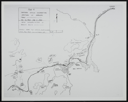
Map showing configuration of potentiometric surfaces in Paleozoic and Cenozoic aquifers in the area between the Las Vegas Valley and the Amargosa Desert, Nevada, 1963
Date
Description
Image
Nevada Women's Archives Records
Identifier
Abstract
Records (1994-1999) are comprised of planning documents, newspaper clippings, external communication, and memoranda documenting the establishment and operations of the Nevada Women's Archives at the University of Nevada, Las Vegas. The records primarily document collection materials from the first exhibit created using the Nevada Women's Archive.
Archival Collection
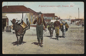
"A typical prospector's outfit, Tonopah, Nevada": postcard
Date
Archival Collection
Description
Image
Map of Southen Nevada Geography: map
Date
Archival Collection
Description
Image

Plat of H.F.M & M addition to city of Las Vegas, Clark County, Nevada, comprising the west 1/2 of N.W. 1/4 Sec. 27, Twp. 20 S., R. 61 E., M.D.B & M, March 8, 1924
Date
Description
Image
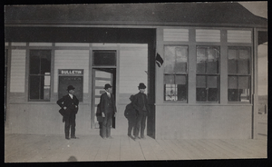
Railroad station, Goldfield, Nevada: photographic print
Date
Archival Collection
Description
Image
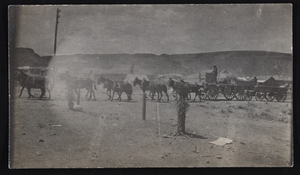
Ore team, Goldfield, Nevada: photographic print
Date
Archival Collection
Description
Image
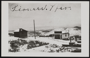
Panoramic view of Pioneer, Nevada: photographic print
Date
Archival Collection
Description
View of Pioneer, Nevada.
Image

Report, Flood control and soil conservation in southern Nevada
Date
Archival Collection
Description
Brief history of flooding along the Virgin River and a list of work undertaken to prevent or diminish future flooding.
Text

Photograph of Nevada governors, Nevada, 1973
Date
Archival Collection
Description
Image