Search Results
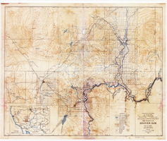
Topographic map of Boulder Canyon Project, Hoover Dam area, 1932
Date
1932
Description
Scale [ca. 1:221,760. 1 in. to approx. 3.5 miles] ; 1 map : col. ; 51 x 62 cm ; Relief shown by contours and spot heights ; "Prepared in Washington Office from compilation made in Las Vegas Office." ; "Map no. 24000." ; Includes township and range grid ; Shows power lines, triangulation stations, boundary monuments, roads, telephone lines, mines, bench marks, etc. ; Department of the Interior, Bureau of Reclamation.
Image
Bob Stupak interested in purchasing Moulin Rouge in Las Vegas, Nevada: video
Date
1999-05-25
Archival Collection
Description
Local news anchors discusses Stupak's latest interest in purchasing the Moulin Rouge in order to restore it; video clips show photographs of the Moulin Rouge and news anchors in front of the empty building; mentions his other ventures including Titanic resort and revamping the Thunderbird Hotel; history of Moulin Rouge and interior and exterior shots of building. Original media VHS, color, aspect ratio 4 x 3, frame size 720 x 486. From the Bob Stupak Professional Papers (MS-01016) -- Professional papers -- Audiovisual material -- Digitized audiovisual clips file.
Moving Image

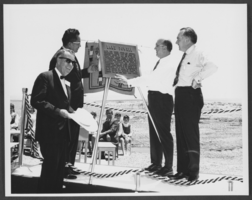
Photograph of Powell Commemorative Ceremony, Lake Powell, June 19, 1969
Date
1969-06-19
Archival Collection
Description
Four dignitaries unveil the plaque dedicated to the memory of John Wesley Powell during a Powell Commemorative Ceremony on Lakeshore Drive, just upstream from Glen Canyon Dam at Lake Powell. From left to right, the people identified include: Governor Jack Williams of Arizona; Chairman Raymond Nakai of the Navajo Tribe; Assistant Secretary of the Interior James R. Smith; and Governor of Utah Calvin L. Rampton.
Image
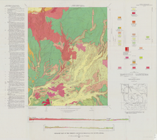
Geologic map of the Thirsty Canyon quadrangle, Nye County, Nevada, 1966
Date
1966
Description
57 x 46 cm., on sheet 83 x 91 cm., folded in envelope 30 x 24 cm. Relief shown by contours and spot heights. "Geology mapped in 1963." Includes 2 colored cross sections, index map, text, and quadrangle location map. "Prepared in cooperation with the U. S. Atomic Commission." Original publisher: Interior, Geological Survey, Series: Geologic quadrangle map GQ, Scale: 1:24 000.
Image
Commissions and commercial project photographs, 1979 to 2005
Level of Description
Series
Scope and Contents
Materials contain photographs, photographic slides, and negatives of commissions and commercial projects painted by Robert Beckmann from 1979 to 2005. The photographs depict murals painted for schools, hotels, casinos, government buildings, museums, and private businesses.
Archival Collection
Robert Beckmann Photographs
To request this item in person:
Collection Number: PH-00381
Collection Name: Robert Beckmann Photographs
Box/Folder: N/A
Collection Name: Robert Beckmann Photographs
Box/Folder: N/A
Archival Component
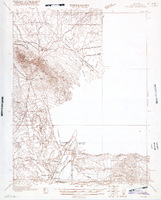
Map of Ely Range Quadrangle, Lincoln County, Nevada, 1921
Date
1921
Description
'Edition of 1921.' 'W. H. Herron, Acting Chief Geographer; Geo. R. Davis, Geographer In Charge; Topography by H. H. Hodgeson, N. E. Ballmer, and W. B. Upton, Jr.; Control by H. H. Hodgeson, Roscoe Reeves, and D. S. Birkett. Surveyed in 1916.' At top of map: ' Topography, State of Nevada.' At upper left corner: ' Department of the Interior, Albert B. Fall, Secretary; U.S. Geological Survey, George Otis Smith, Director.' Southern Nevada Mining Map Collection. 15 minute series (topographic) Nevada.
Image