Search Results
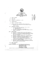
Meeting minutes for Consolidated Student Senate University of Nevada, Las Vegas, February 3, 1993
Date
1993-02-03
Archival Collection
Description
Includes meeting agenda and minutes.
Text

Meeting minutes for Consolidated Student Senate University of Nevada, Las Vegas, May 15, 1995
Date
1995-05-15
Archival Collection
Description
Includes meeting agenda, minutes, and emails. CSUN Session 25 Meeting Minutes and Agendas.
Text

Surficial geologic map of the Specter Range NW quadrangle, Nye County, Nevada, 1989
Date
1989
Description
58 x 47 cm., on sheet 74 x 81 cm., folded in envelope 30 x 24 cm. Relief shown by contours and spot heights. "Geology mapped in 1984-85." Includes text, bibliography, and location maps. "Prepared in cooperation with the U. S. Deparment of Energy." "Base from U. S. Geological Survey, 1961. Photorevised 1983. 10,0000-foot grid ticks based on Nevada coordinate system, central zone. 1000-meter Universal Transverse Mercator grid ticks, zone 11, shown in blue." Original publisher: U. S. Geological Survey, Series: Miscellaneous investigations series map I, Scale: 1:24 000.
Image
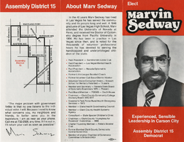
Marvin Sedway campaign materials, item 06
Description
Pamphlet "Elect Marvin Sedway - Experienced, Sensible Leadership in Carson City - Assembly District 15 Democrat"
Building Las Vegas Oral History Project
"Between 1970 and 2010, Southern Nevada’s population increased seven-fold. The urban skyline changed dramatically, while dense suburban tracts pushed at the edges of the desert. The UNLV University Libraries Special Collections and Archives launched the Building Las Vegas collecting initiative in 2016 to collect and preserve evidence about this dramatic growth.
Corporate Body