Search Results

Arthur Walker Gregory Photograph Collection
Identifier
PH-00197
Abstract
The Arthur Walker Gregory Photograph Collection, approximately 1900 to 1920, consists of black-and-white photographic prints, and two corresponding negatives. Two of the images depict the first train to arrive in Las Vegas, Nevada from Salt Lake City, Utah in 1905, one with railroad employees in the foreground. The remaining images depict Arthur Walker Gregory’s class photographs at the Las Vegas Grammar School when he was in the first, third, and fifth grades.
Archival Collection

Map of the Las Vegas ground-water basin, Clark, Nye, and Lincoln Counties, Nevada, 1965
Date
1965
Description
At top of map: 'United States Department of the Interior, Geological Survey. Water-supply paper 1780, plate 1.' At bottom of map: 'Base from Army Map Service sheets NJ 11-9, NJ 11-12, and NI 11-3 (1947).' 'Boundary between bedrock and alluvium in Clark County, Nev., compiled by Ben Boyer, E. H. Pampeyan and C. R. Longwell. In Lincoln and Nye Counties, contact determined from aerial photographs.' 'Interior--Geological Survey, Washington, D.C.--1965--W63358.' Includes township and range lines.Relief shown by contours. Thematic map. Scale 1:250,000 (W 116°--W 114°45´/N 37°00´--N 35°30´). Series: Water-supply paper (Washington, D.C.), 1780. Originally published as plate 1 of Available water supply of the Las Vegas ground-water basin, Nevada, by Glenn T. Malmberg, published by the Geological Survey in 1965 as its Water-supply paper 1780.
Image
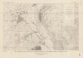
Map of part of Las Vegas Valley, Nevada, showing the approximate area of artesian flow, 1965
Date
1965
Description
At top of map: 'United States Department of the Interior, Geological Survey. Water supply paper 1780, plate 2.' At bottom of map: 'Base from U.S. Geological Survey Las Vegas (1952) and Henderson (1952) quadrangles.' 'Interior--Geological Survey, Washigton, D.C.--1965--W63358.' Relief shown by contours. Includes township and range lines. Thematic map. Scale 1:62,500 (W 115°15´--W 114°45´/N 36°15´--N 36°00´). Series: Water-supply paper (Washington, D.C.)
1780. Originally published as plate 2 of Available water supply of the Las Vegas ground-water basin, Nevada, by Glenn T. Malmberg, published by the Geological Survey in 1965 as its Water-supply paper 1780.
1780. Originally published as plate 2 of Available water supply of the Las Vegas ground-water basin, Nevada, by Glenn T. Malmberg, published by the Geological Survey in 1965 as its Water-supply paper 1780.
Image
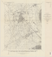
Map of part of Las Vegas Valley, Nevada, showing the approximate altitude of the water table in the near-surface reservoir in February 1956
Date
1965
Description
Genre/Form: Thematic maps. Scale 1:62,500 (W 115°15´--W 115°00´/N 36°15´--N 36°00´). 1 map ; 45 x 36 cm. Series: Water-supply paper (Washington, D.C.) ; 1780. Relief shown by contours. Originally published as plate 8 of Available water supply of the Las Vegas ground-water basin, Nevada, by Glenn T. Malmberg, published by the Geological Survey in 1965 as its Water-supply paper 1780. Includes township and range lines. Interior, Geological Survey
Image
Receipt: Hampton E. George
Date
1901-05-27
Archival Collection
Description
This folder is from "Financial Records" file of the Sadie and Hampton George Papers (MS-00434)
Text

