Search Results
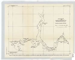
Map of Lake Mead, Arizona-Nevada, showing locations of gages used to establish water-stage elevations during 1947-49 survey
Date
1960
Description
Scale [ca. 1:274,349. 1 in. to approx. 4.33 miles] (W 114°54?--W 113°54?/N 36°36?--N 35°58?). 1 map ; 27 x 34 cm. United States Dept. of the Interior, Geological Survey
Image
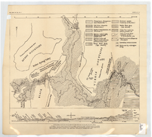
Generalized geological map of the Boulder Reservoir floor and adjacent areas, 1936
Date
1936
Archival Collection
Description
At top of map: 'Bull. Geol. Soc. Am., Vol. 47. Longwell, Pl. 21.' Scale [ca. 1:190,080. 1 in. to approx. 3 miles]. Published as plate 21 in Longwell's Geology of the Boulder Reservoir floor, Arizona-Nevada (1936). Includes a cross-section.
Image
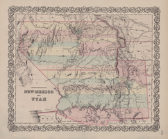
Map of territories of New Mexico and Utah, 1855
Date
1855
Description
29 x 36 cm. Shows natural features, and populated places, wagon route, proposed railroad routes and explorers' routes. Relief shown by hachures. Prime meridians: Greenwich and Washington. "Entered according to act of Congress in the year 1855 by J.H. Colton & Co in the Clerk's Office of the District Court of the U.S. for the Southern District of New York." Hand colored. Atlas p. number in lower-right margin: 51. Decorative border. The geographic region of Southwest is referred to as the New Southwest. Original publisher: J.H. Colton .
Image

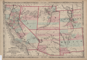
Map of California, territories of New Mexico, Arizona, Colorado, Nevada and Utah, circa 1863
Date
1861 to 1865
Description
40 x 62 cm. Relief shown by hachures and spot heights. Prime meridians: Greenwich and Washington. "Historical and statistical view of the United States, 1860"--Verso. Atlas page numbers at top: 58-59. Arizona became a territory in 1863, and Nevada became a state on October 31, 1864, so this map was either published in 1863 or in 1864 before the end of October. Original publisher: Johnson and Ward.
Image
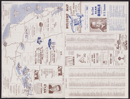
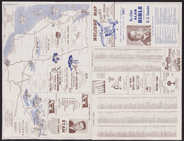
Map of Las Vegas, North Las Vegas, and The Strip, 1956
Date
1956
Description
1956 ed. 'Compiled by Redwood Publishing Co. Copyright 1956 by Robert E. Barringer ... Las Vegas, Nevada.' Panel title: Welcome map, greater Las Vegas area and scenic routes to and from there. Map of California from San Francisco to Los Angeles to Las Vegas drawn by Beth Bergh. Includes notes and street index. Includes advertisements for Las Vegas and California businesses. Scale [ca. 1:35,640. 1 in. to approx. 0.56 mile].
Text