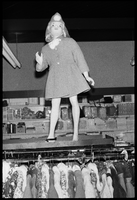
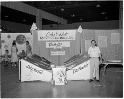
Search the Special Collections and Archives Portal

Search Results

Display    Results Per Page
Displaying results 59821 - 59830 of 830420

Map of Las Vegas and vicinity, Clark County, Nevada, April 15, 1951

Date

1951-04-15

Description

'2nd issue. 4/15/51.' 'Jack Asher, Reg. C.E. & Land Surveyor, Nev. #305.' Cadastral map..

Image

Redevelopment plan map for downtown Las Vegas, Nevada, November 18, 1987

Date

1987-11-18

Description

Scale [ca. 1:12,000. 1 inch equals approx. 1,000 feet]. 1 map ; on sheet 61 x 46 cm. "Nov. 18, 1987." "All land use designations on this map are to be interpreted in conformance with the community profiles component of the Las Vegas General Plan." City of Las Vegas?.

Image

Map of southern California and southern Nevada, 1872

Date

1872

Description

'Entered according to Act of Congress in the year 1872 by Asher & Adams in the office of the Librarian of Congress at Washington.' Scale [ca. 1:1,267,300]. 1 in. to 20 miles (W 124°--W 114°/N 42°--N 32°). Shows natural features, populated places, county boundaries and railroads Prime meridians: Greenwich and Washington. In top margins: 95-96 (south portion). Shows range and township grid. Hand colored. Asher & Adams.

Image

Map of California and Nevada deserts, 1905

Date

1905

Description

'Compiled by G.E. Bailey, E.M. Issued under the auspices of the the Los Angeles Chamber of Commerce and the supervision of its mining committee, Dan Murphy, H.Z. Osborne, Geo. W. Parsons, F.W. Braun, O.P. Posey, 1905.' 'A carefully prepared and authentic map of the desert mining region tributary of Los Angeles, embracing portions of Lincoln, Nye and Esmeralda counties, Nevada, showing location of all water supplies.' At top of page: 'Desert map. California-Nevada'. 'Miner's guide. Springs and waterholes.' Relief shown by hachures. Shows range and township grid. Scale indeterminable (W 119°--W 114°/N 37°--N 33°).

Image

Map of Colorado River Basin, 1928

Date

1928

Description

52 x 46 cm. "Map no. 23000." Shows reservoir sites, irrigated areas, power plants, power sites, dam sites, national parks or monuments, and diversion from basin. Colorado River Basin/Department of the Interior, Bureau of Reclamation; John H. Pellen, chief draftsman. Original publisher: United States. Bureau of Reclamation.

Image

Topographic map of Cane Spring, Nevada quadrangle, 1961

Date

1961

Description

'Mapped, edited and published by the Geological Survey in cooperation with the Atomic Enegry Commission. Control by USGS, USC&GS, USCE, and Atomic Energy Commission. Topography from aerial photographs by photogrammetric methods. Aerial photographs taken 1959. Field check 1961.' Scale 1:24,000 polyconic projection (W 116°07'30"--W 116°00'00"/N 36°52'30"--N 36°45'00"). Series: 7.5 minute series (topographic). Relief shown by contours and spot heights. Contour interval 20 feet. Includes quadrangle location map. Interior--Geological SurveyFor sale by the U.S. Geological Survey

Image

Topographic map of Frenchman Flat quadrangle, Nevada, 1960

Date

1960

Description

'Mapped, edited, and published by the Geological Survery in cooperation with the Atomic Energy Commission. Control by USGS, USC&GS, USCE, and Atomic Energy Commission. Topography from aerial photographs by photogrammetric methods. Aerial photographs taken 1959. Field check 1960.' Scale 1:24,000 polyconic projection (W 116°00'00"--W 115°52'30"/N 36°52'30"--N 36°45'00"). Series: 7.5 minute series (topographic). Relief shown by contours and spot heights. Filing title: Frenchman Flat, Nev. Contour interval 20 feet. opography rom . Includes quadrangle location map. Interior--Geological SurveyFor sale by the U.S. Geological Survey

Image

Map based on reconnaissance of the Zuñi, Little Colorado and Colorado Rivers in 1851 by U.S. Corps of Topographical Engineers

Date

1852

Description

Transcribed from the original: 'Made in 1851 under the direction of Col J.J. Abert, Chief of Corps Topographical Engineers, by BVT. Capt. L. Sitgreaves, T.E., assisted by Lieut. J.G. Parke, T.E., and Mr. M.H. Kern. Drawn by R.H. Kern, 1852.' 'Gila River from a reconnaissance by Maj. Emory, Topographical Engrs. Colorado River below Camp Yuma from a reconnaissance by Lt. Derby Topographical Engrs.' Shows Indian villages and forts. Upper right corner partially missing. Scale [ca. 1:650,000]. Scale of 10 miles to one inch.' 'Ackerman Lith.: 379 Broadway, N.Y.'

Image

Rand-McNally new commercial atlas map of Nevada, 1912

Date

1912

Description

Original publisher: Rand, McNally & Co. Scale [ca. 1:1,203,840). 1 inch to 19 miles. Originally published as p. 316-317 of Rand McNally's commercial atlas of America. Title in right margin: Nevada : commercial atlas of America. Includes township and range grid. Includes index to Nevada railroads and index to principal cities with their populations. Index on verso to counties, towns and natural features in Oregon and Nevada.

Image