Search Results
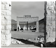
Film transparency of the ruins of the H. D. and L. D. Porter Brothers Store, Rhyolite, Nevada, November 25, 1948
Date
1948-11-25
Archival Collection
Description
An unidentified person looks at the ruins of the H. D. and L. D. Porter Brothers Store in Rhyolite, Nevada. The remains of two wooden buildings and several mining tailing piles are visible in the background. Originally from Illinois, the brothers opened their first store in Johannesburg, Ca. in 1902. Moving with the mining booms, they opened stores in Ballarat, Beatty, Pioneer and Rhyolite. From the Ballarat store, H. D. Porter loaded thirty tons of merchandise onto an 18-mule team freight wagon and came east across Death Valley to the Bullfrog District. The original store was built on Main St. After the move to Golden St., the wooden building was used as a furniture store for the Porter Brothers. With the purchase of a lot on Golden Ave. the construction of a new stone building began in July 1906 and was finished four months later. According to the Rhyolite Herald, November 1906 "This is a large substantial structure, practically fireproof, and occupies a prominent site on Golden Street. The main floor is 30 x 80 feet, with a basement and gallery." Nels Linn was the contractor who did the stonework. The estimated cost was $10,000 for the complete construction of the building. One of the signs that hung from the Porter Brothers Store was "All Things Good But Whiskey". With all the saloons already established in Rhyolite, the Porter Brothers maintained a reputation of never selling liquor. Rhyolite is a ghost town in Nye County, Nevada. It is in the Bullfrog Hills, about 120 miles (190 km) northwest of Las Vegas, near the eastern edge of Death Valley. The town began in early 1905 as one of several mining camps that sprang up after a prospecting discovery in the surrounding hills. During an ensuing gold rush, thousands of gold-seekers, developers, miners and service providers flocked to the Bullfrog Mining District. Many settled in Rhyolite, which lay in a sheltered desert basin near the region's biggest producer, the Montgomery Shoshone Mine. Rhyolite declined almost as rapidly as it rose. After the richest ore was exhausted, production fell. The 1906 San Francisco earthquake and the financial panic of 1907 made it more difficult to raise development capital. In 1908, investors in the Montgomery Shoshone Mine, concerned that it was overvalued, ordered an independent study. When the study's findings proved unfavorable, the company's stock value crashed, further restricting funding. By the end of 1910, the mine was operating at a loss, and it closed in 1911. By this time, many out-of-work miners had moved elsewhere, and Rhyolite's population dropped well below 1,000. By 1920, it was close to zero. After 1920, Rhyolite and its ruins became a tourist attraction and a setting for motion pictures. Most of its buildings crumbled, were salvaged for building materials, or were moved to nearby Beatty or other towns, although the railway depot and a house made chiefly of empty bottles were repaired and preserved. The town is named for rhyolite, an igneous rock composed of light-colored silicates, usually buff to pink and occasionally light gray. It belongs to the same rock class, felsic, as granite but is much less common.
Image
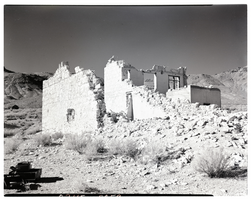
Film transparency of the ruins of possibly the John T. Overbury building, Rhyolite, Nevada, November 25, 1948
Date
1948-11-25
Archival Collection
Description
Film transparency of the ruins of possibly the John T. Overbury building, Rhyolite, Nevada. Rhyolite is a ghost town in Nye County, Nevada. It is in the Bullfrog Hills, about 120 miles (190 km) northwest of Las Vegas, near the eastern edge of Death Valley. The town began in early 1905 as one of several mining camps that sprang up after a prospecting discovery in the surrounding hills. During an ensuing gold rush, thousands of gold-seekers, developers, miners and service providers flocked to the Bullfrog Mining District. Many settled in Rhyolite, which lay in a sheltered desert basin near the region's biggest producer, the Montgomery Shoshone Mine. Rhyolite declined almost as rapidly as it rose. After the richest ore was exhausted, production fell. The 1906 San Francisco earthquake and the financial panic of 1907 made it more difficult to raise development capital. In 1908, investors in the Montgomery Shoshone Mine, concerned that it was overvalued, ordered an independent study. When the study's findings proved unfavorable, the company's stock value crashed, further restricting funding. By the end of 1910, the mine was operating at a loss, and it closed in 1911. By this time, many out-of-work miners had moved elsewhere, and Rhyolite's population dropped well below 1,000. By 1920, it was close to zero. After 1920, Rhyolite and its ruins became a tourist attraction and a setting for motion pictures. Most of its buildings crumbled, were salvaged for building materials, or were moved to nearby Beatty or other towns, although the railway depot and a house made chiefly of empty bottles were repaired and preserved. The town is named for rhyolite, an igneous rock composed of light-colored silicates, usually buff to pink and occasionally light gray. It belongs to the same rock class, felsic, as granite but is much less common.
Image
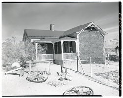
Film transparency of the famous Tom Kelly Bottle House in Rhyolite, Nevada, November 25, 1948
Date
1948-11-25
Archival Collection
Description
The famous Tom Kelly Bottle House in Rhyolite, Nevada, which L. J. (Lewis J. Murphy operated as a free museum in the old ghost town from 1929 until his death in 1953. Two wagon wheels are visible in the front yard. Rhyolite is a ghost town in Nye County, Nevada. It is in the Bullfrog Hills, about 120 miles (190 km) northwest of Las Vegas, near the eastern edge of Death Valley. The town began in early 1905 as one of several mining camps that sprang up after a prospecting discovery in the surrounding hills. During an ensuing gold rush, thousands of gold-seekers, developers, miners and service providers flocked to the Bullfrog Mining District. Many settled in Rhyolite, which lay in a sheltered desert basin near the region's biggest producer, the Montgomery Shoshone Mine. Rhyolite declined almost as rapidly as it rose. After the richest ore was exhausted, production fell. The 1906 San Francisco earthquake and the financial panic of 1907 made it more difficult to raise development capital. In 1908, investors in the Montgomery Shoshone Mine, concerned that it was overvalued, ordered an independent study. When the study's findings proved unfavorable, the company's stock value crashed, further restricting funding. By the end of 1910, the mine was operating at a loss, and it closed in 1911. By this time, many out-of-work miners had moved elsewhere, and Rhyolite's population dropped well below 1,000. By 1920, it was close to zero. After 1920, Rhyolite and its ruins became a tourist attraction and a setting for motion pictures. Most of its buildings crumbled, were salvaged for building materials, or were moved to nearby Beatty or other towns, although the railway depot and a house made chiefly of empty bottles were repaired and preserved. The town is named for rhyolite, an igneous rock composed of light-colored silicates, usually buff to pink and occasionally light gray. It belongs to the same rock class, felsic, as granite but is much less common.
Image
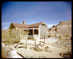
Film transparency of the famous Tom Kelly Bottle House in Rhyolite, Nevada, November 25, 1948
Date
1948-11-25
Archival Collection
Description
The famous Tom Kelly Bottle House in Rhyolite, Nevada, which L. J. (Lewis J. Murphy operated as a free museum in the old ghost town from 1929 until his death in 1953. Two wagon wheels are visible in the front yard. Rhyolite is a ghost town in Nye County, Nevada. It is in the Bullfrog Hills, about 120 miles (190 km) northwest of Las Vegas, near the eastern edge of Death Valley. The town began in early 1905 as one of several mining camps that sprang up after a prospecting discovery in the surrounding hills. During an ensuing gold rush, thousands of gold-seekers, developers, miners and service providers flocked to the Bullfrog Mining District. Many settled in Rhyolite, which lay in a sheltered desert basin near the region's biggest producer, the Montgomery Shoshone Mine. Rhyolite declined almost as rapidly as it rose. After the richest ore was exhausted, production fell. The 1906 San Francisco earthquake and the financial panic of 1907 made it more difficult to raise development capital. In 1908, investors in the Montgomery Shoshone Mine, concerned that it was overvalued, ordered an independent study. When the study's findings proved unfavorable, the company's stock value crashed, further restricting funding. By the end of 1910, the mine was operating at a loss, and it closed in 1911. By this time, many out-of-work miners had moved elsewhere, and Rhyolite's population dropped well below 1,000. By 1920, it was close to zero. After 1920, Rhyolite and its ruins became a tourist attraction and a setting for motion pictures. Most of its buildings crumbled, were salvaged for building materials, or were moved to nearby Beatty or other towns, although the railway depot and a house made chiefly of empty bottles were repaired and preserved. The town is named for rhyolite, an igneous rock composed of light-colored silicates, usually buff to pink and occasionally light gray. It belongs to the same rock class, felsic, as granite but is much less common.
Image
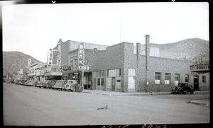
Film transparency of Main Street shops, Ely, Nevada, September, 1937
Date
1937-09
Archival Collection
Description
Main Street shops in Ely, Nevada. Visible are the Bank Club, The Palace, Ely Theatre, State Cafe, Miner's Club, and The Capitol Casino. Ely is the largest city and county seat of White Pine County, Nevada. Ely was founded as a stagecoach station along the Pony Express and Central Overland Route, with the mining boom coming later than the other towns along US 50, with the discovery of copper in 1906. Though the railroads connecting the First Transcontinental Railroad to the mines in Austin and Eureka have long been removed, the railroad to Ely is preserved as a heritage railway by the Nevada Northern Railway and known as the Ghost Train of Old Ely. As of the 2010 census, the population was 4,255.
Image
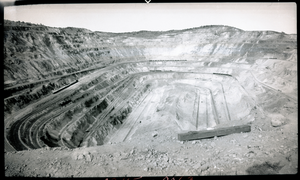
Film transparency of an open-pit copper mine, Ruth, Nevada, August, 1937
Date
1937-08
Archival Collection
Description
An open-pit copper mine located in Ruth, Nevada. Surface mining is done by removing (stripping) surface vegetation, dirt, and, if necessary, layers of bedrock in order to reach buried ore deposits. Techniques of surface mining include: open-pit mining, which is the recovery of materials from an open pit in the ground, quarrying, identical to open-pit mining except that it refers to sand, stone and clay; strip mining, which consists of stripping surface layers off to reveal ore/seams underneath; and mountaintop removal, commonly associated with coal mining, which involves taking the top of a mountain off to reach ore deposits at depth. Most (but not all) placer deposits, because of their shallowly buried nature, are mined by surface methods. Finally, landfill mining involves sites where landfills are excavated and processed.
Image
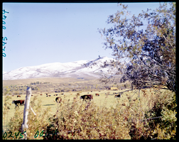
Film transparency of cattle grazing in a field, possibly in Lamoille Valley, Nevada, 1971
Date
1971
Archival Collection
Description
Cattle grazing in a field, possibly in Lamoille Valley, Nevada. Lamoille is located in Elko County, Nevada. It is located about 17 miles (27 km) east of Elko at the base of the Ruby Mountains at an elevation of 5,889 feet (1,795 m) and is part of the Elko Micropolitan Statistical Area. The early history of the community and surrounding area is summarized in a nearby highway marker. John Walker and Thomas Waterman first settled the area in 1865. Waterman named the valley after his native Vermont. In 1868, Walker erected the Cottonwood Hotel, store and blacksmith shop in the valley, and the settlement became known as "The Crossroads." Here wagons were repaired and food and supplies could be obtained. The original buildings and the more recent 20-bedroom Lamoille hotel, creamery, flour mill and dance hall are gone. Lamoille is nestled off the western flanks of the Ruby Mountains at the end of Nevada State Route 227, and is the principal gateway to this range via the National Forest Scenic Byway up Lamoille Canyon.
Image
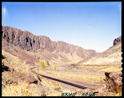
Film transparency of railroad tracks in Northern Nevada, 1971
Date
1971
Archival Collection
Description
Railroad tracks run trough a canyon in Northern Nevada.
Image
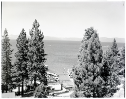
Film transparency of Lake Tahoe, Nevada, circa 1940s
Date
1940 to 1949
Archival Collection
Description
A view of Lake Tahoe, Nevada, as seen through a stand of trees. A small marina with a few boats in the slips is visible in the foreground.
Image
Film transparency of Grand Canyon, Arizona, January 8, 1955
Date
1955-01-08
Archival Collection
Description
A view of the Grand Canyon, taken from the Rim.
Image