Search Results
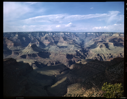
Film transparency of the North Rim of the Grand Canyon, Arizona, 1955
Date
1955
Archival Collection
Description
A view of the North Rim of the Grand Canyon, taken from the South Rim. The Colorado River is barely visible at the bottom of the photograph.
Image

Film transparency of the North Rim of the Grand Canyon, Arizona, circa 1930s-1940s
Date
1930 to 1949
Archival Collection
Description
A view of the North Rim of the Grand Canyon, taken from the South Rim.
Image
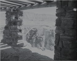
Film transparency of of the Navajo Bridge, Grand Canyon, Arizona, circa 1930s
Date
1930 to 1939
Archival Collection
Description
A view of the Navajo Bridge from inside an adjacent stone building, possibly the Old Cliff Dwellers Lodge (Blanche Russell Rock House), that was built circa 1920. Navajo Bridge crosses the Colorado River's Marble Canyon near Lee's Ferry in Arizona. It carries U.S. Route 89A. Spanning Marble Canyon, the bridge carries U.S. Route 89A northbound travelers to southern Utah and to the Arizona Strip, the otherwise inaccessible portion of Arizona north of the Colorado River, which includes the North Rim of Grand Canyon National Park. Prior to the construction of the first Navajo Bridge, the only river crossing from Arizona to Utah was at nearby Lee's Ferry, where the canyon walls are low and getting vehicles onto the water is relatively convenient. The ferry offered only unreliable service, however, as adverse weather and flooding regularly prevented its operation. Construction of the original Navajo Bridge began in 1927, and the bridge opened to traffic in 1929. The steel spandrel bridge design was constructed by the Kansas City Structural Steel Company. The bridge is 834 feet (254 m) in length, with a maximum height of 467 feet (142 m) from the canyon floor. Its roadway offers an 18-foot (5.5 m) surface width with a load capacity of 22.5 tons (although the posted legal weight limit was 40 tons). In 1990, however, it was decided that the traffic flow was too great for the original bridge, and that a new solution was needed. Deciding on a solution was difficult, due to the many local interests. Issues included preservation of sacred Navajo land, endangered plant species in Marble Canyon, and the possibility of construction pollution entering the river. A new steel arch bridge was commissioned by the Arizona Department of Transportation and the Federal Highway Administration, and was completed in September 1995, at a cost of approximately $15 million. The original Navajo Bridge is still open to pedestrian and equestrian use, and an interpretive center has been constructed nearby to showcase the historical nature of the bridge and early crossing of the Colorado River. Bungee jumpers are frequently seen using the span. The original bridge has been designated as a Historic Civil Engineering Landmark. The bridge was placed on the National Register of Historic Places on August 13, 1981.
Image

Film transparency of the North rim of the Grand Canyon, Arizona, circa 1930s-1940s
Date
1930 to 1949
Archival Collection
Description
A view of the North Rim of the Grand Canyon, taken from the South Rim.
Image

Film transparency of the North Rim of the Grand Canyon, Arizona, circa 1930s-1940s
Date
1930 to 1949
Archival Collection
Description
A view of the North Rim of the Grand Canyon, taken from the South Rim.
Image
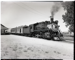
Virginia & Truckee Railroad engine No. 5, circa 1940s
Date
1940 to 1949
Archival Collection
Description
Virginia & Truckee Railroad engine No. 5 stopped at Minden, Nevada. Minden is located in Douglas County, Nevada. The population was 3,001 at the 2010 census. It is the county seat of Douglas County and is adjacent to the city of Gardnerville. It was founded in 1906 by Heinrich Friedrich Dangberg Jr., who named it after the town of Minden, in the German state of North Rhine-Westphalia, which was near his father's birthplace. Minden was founded on company land of the Dangberg Home Ranch and Dangberg commissioned most of the town's early buildings. Minden has had a post office since 1906. U.S. Highway 395 runs through Minden. It is also the terminus of State Route 88, which becomes California State Route 88 on the west side of the state line.
Image

Film transparency of Mr. L. J. (Lewis J.) Murphy and the famous Tom Kelly Bottle House in Rhyolite, Nevada, November 25, 1948
Date
1948-11-25
Archival Collection
Description
Mr. L. J. (Lewis J.) Murphy and the famous Tom Kelly Bottle House in Rhyolite, Nevada, which he operated as a free museum in the old ghost town. L. J. Murphy took care of the Bottle House from 1929 until his death in 1953. Two wagon wheels are visible in the front yard. Rhyolite is a ghost town in Nye County, Nevada. It is in the Bullfrog Hills, about 120 miles (190 km) northwest of Las Vegas, near the eastern edge of Death Valley. The town began in early 1905 as one of several mining camps that sprang up after a prospecting discovery in the surrounding hills. During an ensuing gold rush, thousands of gold-seekers, developers, miners and service providers flocked to the Bullfrog Mining District. Many settled in Rhyolite, which lay in a sheltered desert basin near the region's biggest producer, the Montgomery Shoshone Mine. Rhyolite declined almost as rapidly as it rose. After the richest ore was exhausted, production fell. The 1906 San Francisco earthquake and the financial panic of 1907 made it more difficult to raise development capital. In 1908, investors in the Montgomery Shoshone Mine, concerned that it was overvalued, ordered an independent study. When the study's findings proved unfavorable, the company's stock value crashed, further restricting funding. By the end of 1910, the mine was operating at a loss, and it closed in 1911. By this time, many out-of-work miners had moved elsewhere, and Rhyolite's population dropped well below 1,000. By 1920, it was close to zero. After 1920, Rhyolite and its ruins became a tourist attraction and a setting for motion pictures. Most of its buildings crumbled, were salvaged for building materials, or were moved to nearby Beatty or other towns, although the railway depot and a house made chiefly of empty bottles were repaired and preserved. The town is named for rhyolite, an igneous rock composed of light-colored silicates, usually buff to pink and occasionally light gray. It belongs to the same rock class, felsic, as granite but is much less common.
Image
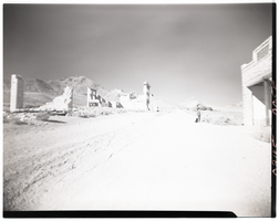
Film transparency of a boy looking at an abandonded building, Rhyolite, Nevada, November 25, 1948
Date
1948-11-25
Archival Collection
Description
A young boy looks at the ruins of the H. D. and L. D. Porter Brothers Store in Rhyolite, Nevada. Several other buildings are visible in the background. Rhyolite is a ghost town in Nye County, Nevada. It is in the Bullfrog Hills, about 120 miles (190 km) northwest of Las Vegas, near the eastern edge of Death Valley. The town began in early 1905 as one of several mining camps that sprang up after a prospecting discovery in the surrounding hills. During an ensuing gold rush, thousands of gold-seekers, developers, miners and service providers flocked to the Bullfrog Mining District. Many settled in Rhyolite, which lay in a sheltered desert basin near the region's biggest producer, the Montgomery Shoshone Mine. Rhyolite declined almost as rapidly as it rose. After the richest ore was exhausted, production fell. The 1906 San Francisco earthquake and the financial panic of 1907 made it more difficult to raise development capital. In 1908, investors in the Montgomery Shoshone Mine, concerned that it was overvalued, ordered an independent study. When the study's findings proved unfavorable, the company's stock value crashed, further restricting funding. By the end of 1910, the mine was operating at a loss, and it closed in 1911. By this time, many out-of-work miners had moved elsewhere, and Rhyolite's population dropped well below 1,000. By 1920, it was close to zero. After 1920, Rhyolite and its ruins became a tourist attraction and a setting for motion pictures. Most of its buildings crumbled, were salvaged for building materials, or were moved to nearby Beatty or other towns, although the railway depot and a house made chiefly of empty bottles were repaired and preserved. The town is named for rhyolite, an igneous rock composed of light-colored silicates, usually buff to pink and occasionally light gray. It belongs to the same rock class, felsic, as granite but is much less common.
Image
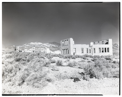
Film transparency of the ruins of several buildings, Rhyolite, Nevada, November 25, 1948
Date
1948-11-25
Archival Collection
Description
An unidentified person looks at the ruins of the school. Several other buildings are also visible. The Las Vegas and Tonopah Railroad Depot is visible in the background at the left of the photograph. To the right of the train depot is the was the John S. Cook & Co. Bank building on Golden Street. The building visible between the bank and the school was possibly the John T. Overbury building.
Image
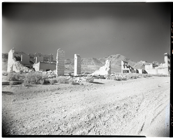
Film transparency of buildings located on Golden Street, Rhyolite, Nevada, November 25, 1948
Date
1948-11-25
Archival Collection
Description
Two buildings that were located on Golden Street in Rhyolite, Nevada. The building on the left was possibly the John T. Overbury building. The building on the right was the John S. Cook & Co. Bank building. Rhyolite is a ghost town in Nye County, Nevada. It is in the Bullfrog Hills, about 120 miles (190 km) northwest of Las Vegas, near the eastern edge of Death Valley. The town began in early 1905 as one of several mining camps that sprang up after a prospecting discovery in the surrounding hills. During an ensuing gold rush, thousands of gold-seekers, developers, miners and service providers flocked to the Bullfrog Mining District. Many settled in Rhyolite, which lay in a sheltered desert basin near the region's biggest producer, the Montgomery Shoshone Mine. Rhyolite declined almost as rapidly as it rose. After the richest ore was exhausted, production fell. The 1906 San Francisco earthquake and the financial panic of 1907 made it more difficult to raise development capital. In 1908, investors in the Montgomery Shoshone Mine, concerned that it was overvalued, ordered an independent study. When the study's findings proved unfavorable, the company's stock value crashed, further restricting funding. By the end of 1910, the mine was operating at a loss, and it closed in 1911. By this time, many out-of-work miners had moved elsewhere, and Rhyolite's population dropped well below 1,000. By 1920, it was close to zero. After 1920, Rhyolite and its ruins became a tourist attraction and a setting for motion pictures. Most of its buildings crumbled, were salvaged for building materials, or were moved to nearby Beatty or other towns, although the railway depot and a house made chiefly of empty bottles were repaired and preserved. The town is named for rhyolite, an igneous rock composed of light-colored silicates, usually buff to pink and occasionally light gray. It belongs to the same rock class, felsic, as granite but is much less common.
Image