Search Results
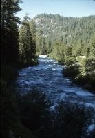
Slide of the Truckee River, circa 1970s
Date
1970 to 1979
Archival Collection
Description
The location that the photograph was taken is unknown, but is most likely in Nevada. The Truckee River is a stream in the U. S. states of California and Nevada. The river flows northeasterly and is 121 miles (195 km) long. The Truckee is the sole outlet of Lake Tahoe and drains part of the high Sierra Nevada, emptying into Pyramid Lake in the Great Basin. Its waters are an important source of irrigation along its valley and adjacent valleys.
Image
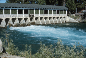
Slide of the Truckee River Dam, Tahoe City, California, circa 1970s
Date
1970 to 1979
Archival Collection
Description
Truckee River Dam at the Lake Tahoe shoreline, on the northwest side of the lake near Tahoe City, California. There is a sign posted on the dam stating "No fishing for 1000 feet below dam."
Image
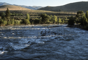
Slide of the Truckee River Canyon, circa 1970s
Date
1970 to 1979
Archival Collection
Description
A view of the Truckee River Canyon. The location that the photograph was taken is unknown.
Image
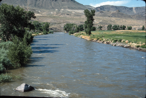
Slide of the Truckee River canyon near Reno, Nevada, circa 1970s
Date
1970 to 1979
Archival Collection
Description
A view of the Truckee River canyon near Reno, Nevada.
Image
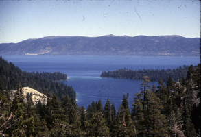
Slide of Lake Tahhoe, May, 1966
Date
1966-05
Archival Collection
Description
A view of Lake Tahoe and Emerald Bay, May 1966. Emerald Bay is located on the California side of Lake Tahoe.
Image
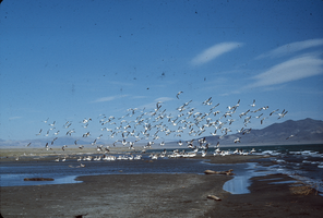
Slide of pelicans at Pyramid Lake, Nevada, circa 1970s
Date
1970 to 1979
Archival Collection
Description
A flock of pelicans at Pyramid Lake, Nevada. Some birds are wading near a sand bar, while others are airborne. Pyramid Lake is the geographic sink of the Truckee River Basin, 40 mi (64 km) northeast of Reno. Pyramid Lake is fed by the Truckee River, which is mostly the outflow from Lake Tahoe. The Truckee River enters Pyramid Lake at its southern end. Pyramid Lake has no outlet, with water leaving only by evaporation, or sub-surface seepage (an endorheic lake). The lake has about 10% of the area of the Great Salt Lake, but it has about 25% more volume. The salinity is approximately 1/6 that of sea water. Although clear Lake Tahoe forms the headwaters that drain to Pyramid Lake, the Truckee River delivers more turbid waters to Pyramid Lake after traversing the steep Sierra terrain and collecting moderately high silt-loaded surface runoff. Pyramid Lake is the site of some of the Earth's most spectacular tufa deposits. Tufa is a rock composed of calcium carbonate (CaCO3) that forms at the mouth of a spring, from lake water, or from a mixture of spring and lake water. The explorer John C. Fremont (1845) wrote about the tufas during his 1843-44 expedition and named the lake after the pyramidal-shaped island that lies along the east shore of the lake. The Paiute name for the island is Wono, meaning cone-shaped basket. The Paiute name for the lake is Cui-Ui Panunadu, meaning fish in standing water.
Image

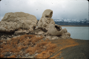
Slide of a tufa deposit in Pyramid Lake, Nevada, circa 1970s
Date
1970 to 1979
Archival Collection
Description
The pyramid-shaped island tufa that lies along the east shore of the lake and is the reason the lake was named Pyramid Lake. Pyramid Lake is the geographic sink of the Truckee River Basin, 40 mi (64 km) northeast of Reno. Pyramid Lake is fed by the Truckee River, which is mostly the outflow from Lake Tahoe. The Truckee River enters Pyramid Lake at its southern end. Pyramid Lake has no outlet, with water leaving only by evaporation, or sub-surface seepage (an endorheic lake). The lake has about 10% of the area of the Great Salt Lake, but it has about 25% more volume. The salinity is approximately 1/6 that of sea water. Although clear Lake Tahoe forms the headwaters that drain to Pyramid Lake, the Truckee River delivers more turbid waters to Pyramid Lake after traversing the steep Sierra terrain and collecting moderately high silt-loaded surface runoff. Pyramid Lake is the site of some of the Earth's most spectacular tufa deposits. Tufa is a rock composed of calcium carbonate (CaCO3) that forms at the mouth of a spring, from lake water, or from a mixture of spring and lake water. The explorer John C. Fremont (1845) wrote about the tufas during his 1843-44 expedition and named the lake after the pyramidal-shaped island that lies along the east shore of the lake. The Paiute name for the island is Wono, meaning cone-shaped basket. The Paiute name for the lake is Cui-Ui Panunadu, meaning fish in standing water.
Image
Slide of the rock formation known as The Squaw and Her Basket, Pyramid Lake, Nevada, circa 1970s
Date
1970 to 1979
Archival Collection
Description
The rock formation known as The Squaw and Her Basket, Pyramid Lake, Nevada. Pyramid Lake is the geographic sink of the Truckee River Basin, 40 mi (64 km) northeast of Reno. Pyramid Lake is fed by the Truckee River, which is mostly the outflow from Lake Tahoe. The Truckee River enters Pyramid Lake at its southern end. Pyramid Lake has no outlet, with water leaving only by evaporation, or sub-surface seepage (an endorheic lake). The lake has about 10% of the area of the Great Salt Lake, but it has about 25% more volume. The salinity is approximately 1/6 that of sea water. Although clear Lake Tahoe forms the headwaters that drain to Pyramid Lake, the Truckee River delivers more turbid waters to Pyramid Lake after traversing the steep Sierra terrain and collecting moderately high silt-loaded surface runoff. Pyramid Lake is the site of some of the Earth's most spectacular tufa deposits. Tufa is a rock composed of calcium carbonate (CaCO3) that forms at the mouth of a spring, from lake water, or from a mixture of spring and lake water. The explorer John C. Fremont (1845) wrote about the tufas during his 1843-44 expedition and named the lake after the pyramidal-shaped island that lies along the east shore of the lake. The Paiute name for the island is Wono, meaning cone-shaped basket. The Paiute name for the lake is Cui-Ui Panunadu, meaning fish in standing water.
Image
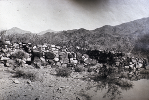
Slide of the Callville ruins, Callville, Nevada, circa 1930s
Date
1930 to 1939
Archival Collection
Description
A view of the Callville ruins at Lake Mead, Nevada. Callville is a former settlement of Clark County, Nevada. Abandoned in 1869, Callville was submerged under 400 feet (120 m) of water after the Colorado River was dammed to form Lake Mead. Callville Bay recreation area is located at the site. Located 350 miles (560 km) from Salt Lake City, Calville was situated on the west bank of the Colorado River, in what was at the time Pah-Ute County, Arizona Territory. The main road to the settlement was along the Virgin River close to St. Thomas, Nevada before heading over hills to the west. A road connected Callville with the main highway at Las Vegas. Callville was established in December 2, 1864 by Anson Call, Dr. James M. Whitmore, A. M. Cannon, Jacob Hamblin and son. It was at the time the southernmost outpost of Mormon settlement. Callville was one of seven Mormon settlements on or near the Muddy River, the others being St. Thomas, Saint Joseph, Overton, West Point, Mill Point later Simonsville and Rioville on the Colorado River above its confluence with the Virgin River. Callville became the county seat of Pah-Ute County, Arizona Territory, in December 1865, before the seat was moved on October 1, 1867 to St. Thomas.
Image
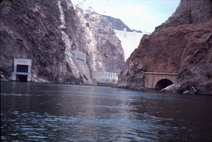
Slide of Hoover Dam taken on the downstream side, circa 1970s
Date
1970 to 1979
Archival Collection
Description
The face of Hoover Dam as seen from the river. Part of the power plant's hydroelectric generators, as well as the canyon wall outlets and stoney gate are visible on the Nevada (left) side. The spillway tunnel is visible on the Arizona (right) side. During the years of lobbying leading up to the passage of legislation authorizing the dam in 1928, Hoover Dam was originally referred to "Boulder Dam" or as "Boulder Canyon Dam", even though the proposed site had shifted to Black Canyon. The Boulder Canyon Project Act of 1928 (BCPA) never mentions a proposed name or title for the dam. When Secretary Wilbur spoke at the ceremony starting the building of the railway between Las Vegas and the dam site on September 17, 1930, he named the dam "Hoover Dam", citing a tradition of naming dams after Presidents, though none had been so honored during their terms of office. After Hoover's election defeat in 1932 and the accession of the Roosevelt administration, Secretary Ickes ordered on May 13, 1933 that the dam be referred to as "Boulder Dam". In the following years, the name "Boulder Dam" failed to fully take hold, with many Americans using both names interchangeably and map makers divided as to which name should be printed. In 1947, a bill passed both Houses of Congress unanimously restoring the name to "Hoover Dam".
Image