Search Results

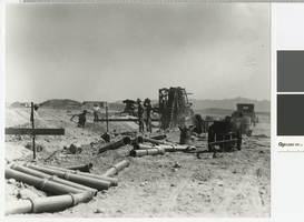
Photograph of men laying sewer pipe in Boulder City, circa 1931
Date
1931 to 1935
Archival Collection
Description
Laying a sewer line in Boulder City.
Transcribed Notes: Written on back: 10-12-31
Image


Photograph of three unidentified men at the Sands Hotel and Casino, Las Vegas, circa late 1950s - early 1960s
Date
1955 to 1965
Archival Collection
Description
Three unidentified men working with an open manhole outside of the Valet shop at the Sands Hotel and Casino in Las Vegas, Nevada.
Image
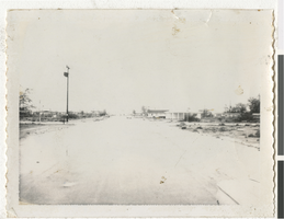
Photograph of Vegas Heights, Las Vegas (Nev.), 1964
Date
1964
Archival Collection
Description
Balzar and Revere Streets in Vegas Heights where, at the time, there were no sewers or proper drainage. This lead to flooded streets during severe rainstorms.
Image