Search Results


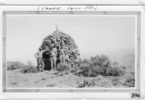
Photograph of Don Schuyler, Sr. on a survey crew with the U. S. Coast and Geodetic Survey at the Powell Cairn, Garfield County, Utah, circa 1935
Date
1933 to 1937
Archival Collection
Description
Donald Richard Schuyler, Sr. on a survey crew with the U.S. Coast and Geodetic Survey at the Powell Cairn, circa 1935. Powell Cairn was built about 1880 by John Wesley Powell on his exploration of the southwestern United States. The Powell Survey Cairn is located in Garfield County, Utah, at N37.93193° W112.20548° (NAD83) and at an elevation of 10216 ft MSL. The primary coordinates for Powell Survey Cairn places it within the ZIP Code 84712 delivery area. It can be seen on the USGS 1:24K topographic map Adams Head, UT.
Image


Meeting minutes for Consolidated Student Senate, University of Nevada, Las Vegas, January 10, 2000
Date
2000-01-10
Archival Collection
Description
Includes meeting minutes and agenda. CSUN Session 30 (Part 1) Meeting Minutes and Agendas.
Text