Search Results
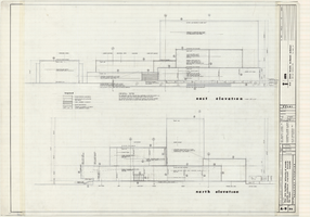
Architectural drawings of Fine Arts Building, University of Nevada Southern Regional Branch, Las Vegas, Nevada, east and north exterior elevations, July 15, 1963
Date
Archival Collection
Description
East and north exterior elevations of the Fine Arts Building (later to become the Judy Bayley Theatre) at the University of Nevada Southern Regional Branch, Las Vegas, Nevada (later University of Nevada, Las Vegas). Scale: 1/8" = 1'-0". "Sheet A-9 of 26." "Drawn: JM. Checked: JBM. Date 10 July 63. Submittal dates: preliminary 12-7-62; intermediate 3-17-63; final 7-15-63." "Bolt , Beranek and Newman Inc., consultants in acoustics. D'autremont-Helms & Assoc., consulting mechanical engineers. Helin Engineering Co., electrical engineers." "Fund code no. 82301." "State of Nevada Planning Board, Carson City, Nevada."
Site Name: University of Nevada. Southern Regional Division
Address: 4505 S. Maryland Parkway
Image
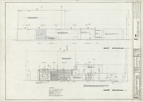
Architectural drawings of Fine Arts Building, University of Nevada Southern Regional Branch, Las Vegas, Nevada, west and south exterior elevations, July 15, 1963
Date
Archival Collection
Description
West and south exterior elevations of the Fine Arts Building (later to become the Judy Bayley Theatre) at the University of Nevada Southern Regional Branch, Las Vegas, Nevada (later University of Nevada, Las Vegas). Scale: 1/8" = 1'-0". "Sheet A-10 of 26." "Drawn: JM. Checked: JBM. Date 10 July 63. Submittal dates: preliminary 12-7-62; intermediate 3-17-63; final 7-15-63." "Bolt , Beranek and Newman Inc., consultants in acoustics. D'Autremont-Helms & Assoc., consulting mechanical engineers. Helin Engineering Co., electrical engineers." "Fund code no. 82301." "State of Nevada Planning Board, Carson City, Nevada."
Site Name: University of Nevada. Southern Regional Division
Address: 4505 S. Maryland Parkway
Image
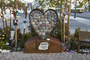
The "Vegas Strong" heart sculpture at the Las Vegas Community Healing Garden, looking south in Las Vegas, Nevada: digital photograph
Date
Archival Collection
Description
Following the October 1, 2017 killing of 58 people at the Route 91 Harvest Music Festival on the Las Vegas Strip, the Las Vegas community responded in a variety of ways. Envisioned by activists and built by volunteers, the City of Las Vegas established the Las Vegas Community Healing Garden at 1015 S. Casino Center Boulevard to honor the victims and give family members and the community a place to gather to remember.
Image
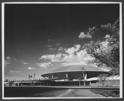
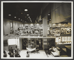
Photograph of Las Vegas Convention Center, Las Vegas, 1966
Date
Archival Collection
Description
Image
Letter from Robert E. Jones (Las Vegas) to Las Vegas Land and Water Company (Las Vegas), January 18, 1949
Date
Archival Collection
Description
Las Vegas Valley Water District lawyers broaching the subject of purchasing the Las Vegas Land and Water Company
Text
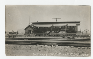
Postcard of the Las Vegas Depot, Las Vegas (Nev.), 1905
Date
Archival Collection
Description
Caption: Salt Lake Depot Las Vegas 1905
Image
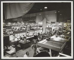
Photograph of Las Vegas Convention Center, Las Vegas, 1966
Date
Archival Collection
Description
Image
Photograph of Las Vegas Convention Center, Las Vegas, 1966
Date
Archival Collection
Description
Image
Las Vegas Monorail Records
Identifier
Abstract
The Las Vegas Monorail Records (1971-1980) consist of articles, newspaper clippings, agency reports, and correspondence concerning the 1970s effort to construct a Las Vegas, Nevada mass-transit monorail system. Materials document the project conception, development, and ultimate failureroughout the 1970s.
Archival Collection

Map of the city of Las Vegas, North Las Vegas, "the Strip," 1960
Date
Description
Image