Search Results
Hydroscience Geology coursework, 1989-1990
Level of Description
File
Archival Collection
David Donovan Collection on Hydrology and Geology
To request this item in person:
Collection Number: MS-00813
Collection Name: David Donovan Collection on Hydrology and Geology
Box/Folder: Box 18
Collection Name: David Donovan Collection on Hydrology and Geology
Box/Folder: Box 18
Archival Component
"Geology of Arizona," seminar paper, 1926
Level of Description
File
Archival Collection
Franklin M. Murphy Geological Papers
To request this item in person:
Collection Number: MS-00202
Collection Name: Franklin M. Murphy Geological Papers
Box/Folder: Box 05
Collection Name: Franklin M. Murphy Geological Papers
Box/Folder: Box 05
Archival Component
Report from U.S. Geological Survey on pottery
Date
1912
Archival Collection
Description
This folder is from "Maps and Assorted Documents" file of the Sadie and Hampton George Papers (MS-00434)
Text
Preliminary Reconnaissance Geologic Map of Central Nevada - United States Department of the Interior, Geological Survey, undated
Level of Description
File
Archival Collection
Yucca Mountain Site Characterization Office Collection
To request this item in person:
Collection Number: MS-00091
Collection Name: Yucca Mountain Site Characterization Office Collection
Box/Folder: Box 77
Collection Name: Yucca Mountain Site Characterization Office Collection
Box/Folder: Box 77
Archival Component
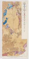
Geologic map of the Atomic Energy Commission Nevada Proving Grounds Area, Nye and Clark Counties, Nevada, 1952
Date
1952
Description
'At top of map: ' United States Department of the Interior. Geological Survey.' ' Bulletin 1021, Plate 32.' At bottom of map: 'Geology by Donald E. Hibbard and Mike S. Johnson, 1952.' 'Base from USAF Aeronautical Chart and Information Service, April 1952.' 'Interior--Geological Survey, Washington, D.C. MR-3767.' Scale 1:63,360 (W 116°10--W 115°55/N 37°15--N 36°40)
Geological Survey bulletin, 1021
Image
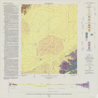
Geologic map of the Frenchman Flat quadrangle, Nye, Lincoln, and Clark Counties, Nevada, 1965
Date
1965
Description
58 x 47 cm., on sheet 81 x 81 cm., folded in envelope 30 x 24 cm. Relief shown by contours and spot heights. "Geology mapped in 1962. Contours on pre-Cenozoic rocks by D. L. Healey and C. H. Miller, 1958-63." Includes text, col. cross section and quadrangle location map. "Prepared in cooperation with the U.S. Atomic Energy Commission." Original publisher: Interior, Geological Survey, Series: Geologic quadrangle map GQ, Scale: 1:24 000.
Image
U.S. Geological Survey aerial photographs
Level of Description
File
Archival Collection
Jeff Van Ee Papers
To request this item in person:
Collection Number: MS-00470
Collection Name: Jeff Van Ee Papers
Box/Folder: N/A
Collection Name: Jeff Van Ee Papers
Box/Folder: N/A
Archival Component
Publications and geological surveys, 1896-1918
Level of Description
File
Archival Collection
C. A. Earle Rinker Papers
To request this item in person:
Collection Number: MS-00514
Collection Name: C. A. Earle Rinker Papers
Box/Folder: N/A
Collection Name: C. A. Earle Rinker Papers
Box/Folder: N/A
Archival Component
Geology field class notes, 1971
Level of Description
File
Archival Collection
Jeanne Russell Janish Papers
To request this item in person:
Collection Number: MS-00355
Collection Name: Jeanne Russell Janish Papers
Box/Folder: Box 06
Collection Name: Jeanne Russell Janish Papers
Box/Folder: Box 06
Archival Component
Geology field class notes, 1924
Level of Description
File
Archival Collection
Jeanne Russell Janish Papers
To request this item in person:
Collection Number: MS-00355
Collection Name: Jeanne Russell Janish Papers
Box/Folder: Box 06
Collection Name: Jeanne Russell Janish Papers
Box/Folder: Box 06
Archival Component