Search Results
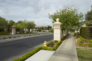
Landscaping and a sidewalk along Grand Hills Drive near Eastern Avenue, looking southwest in Henderson, Nevada: digital photograph
Date
Archival Collection
Description
From the UNLV University Libraries Photographs of the Development of the Las Vegas Valley, Nevada (PH-00394). Part of the collection documents the entire 19 mile length of the north/south Eastern Avenue / Civic Center Drive alignment. This photograph was captured in the section of Eastern Avenue between Sunridge Heights Parkway and Grand Hills Drive.
Image
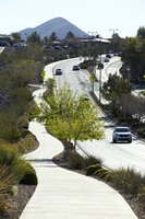
A pathway along Sun City Anthem Drive west of Eastern Avenue, looking east-northeast in Henderson, Nevada: digital photograph
Date
Archival Collection
Description
From the UNLV University Libraries Photographs of the Development of the Las Vegas Valley, Nevada (PH-00394). Part of the collection documents the entire 19 mile length of the north/south Eastern Avenue / Civic Center Drive alignment. This photograph was captured in the section of Eastern Avenue between Grand Hills and Sun City Anthem Drives.
Image
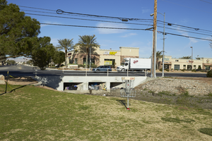
A flood control channel under the Eastern Avenue at Sunset Park, looking west in Las Vegas, Nevada: digital photograph
Date
Archival Collection
Description
From the UNLV University Libraries Photographs of the Development of the Las Vegas Valley, Nevada (PH-00394). Part of the collection documents the entire 19 mile length of the north/south Eastern Avenue / Civic Center Drive alignment. This photograph was captured in the section of Eastern Avenue between Sunset and Warm Springs Roads.
Image
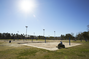
A maintenance worker smooths the sand in the volleyball courts at Sunset Park, looking southeast in Las Vegas, Nevada: digital photograph
Date
Archival Collection
Description
From the UNLV University Libraries Photographs of the Development of the Las Vegas Valley, Nevada (PH-00394). Part of the collection documents the entire 19 mile length of the north/south Eastern Avenue / Civic Center Drive alignment. This photograph was captured in the section of Eastern Avenue between Sunset and Warm Springs Roads.
Image

A traffic sign along Eastern Avenue, looking north-northwest in Las Vegas, Nevada: digital photograph
Date
Archival Collection
Description
From the UNLV University Libraries Photographs of the Development of the Las Vegas Valley, Nevada (PH-00394). Part of the collection documents the entire 19 mile length of the north/south Eastern Avenue / Civic Center Drive alignment. This photograph was captured in the section of Eastern Avenue between Stewart Avenue and Charleston Boulevard.
Image
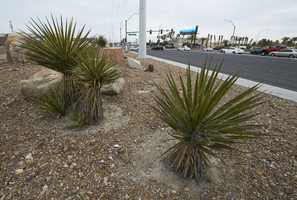
Landscaping for the I-215 the Beltway and Eastern Avenue, looking north in Las Vegas, Nevada: digital photograph
Date
Archival Collection
Description
From the UNLV University Libraries Photographs of the Development of the Las Vegas Valley, Nevada (PH-00394). Part of the collection documents the entire 19 mile length of the north/south Eastern Avenue / Civic Center Drive alignment. This photograph was captured in the section of Eastern Avenue between Pebble Road and Silverado Ranch Boulevard.
Image
Dale Scheideman Architectural Records
Identifier
Abstract
The Dale Scheideman Architectural Records (1955-1956) contain student work created by architect Elton Dale Scheideman during his time at the University of Kansas School of Architecture. These drawings, mounted on mat boards, were submitted for architectural classes and student design competitions.
Archival Collection
Hughes HK-1 Hercules photographs, 1945-1947
Level of Description
Scope and Contents
Materials contain photographs of the HK-1 Hercules, otherwise known as the "Spruce Goose" or the "Flying Boat," from 1945 to 1947. The photographs primarily depict the construction, transportation, and storage of the plane, but also include the first and only test flight of the HK-1 above Los Angeles Harbor in 1947. Howard Hughes designed the HK-1 as the world's largest plane, capable of transporting large quantities of U.S. military hardware and personnel. In 1947, under the program's new designation H-4 Hercules, Hughes had the plane transported from his factory in Culver City, California to Los Angeles Harbor. On November 2, he piloted the plane during its only test flight. The U.S. Air Force abandoned the controversial project, and Hughes was called to testify before the Truman Committee of the U.S. Senate to justify the use of government funds on a program that never succeeded.
Archival Collection
Collection Name: Howard Hughes Public Relations Photograph Collection
Box/Folder: N/A
Archival Component