Search Results
Helen J. Stewart Photographs
Identifier
PH-00104
Abstract
The Helen J. Stewart Photographs depict the Stewart Family from approximately 1860 to 1950. The photographs primarily depict Helen J. Stewart and her children as well as the Stewart Ranch (also know as the Las Vegas Ranch) in Southern Nevada. The photographs include the early Las Vegas, Nevada town site, landscapes of Southern Nevada and the American Southwest, mines and mining camps, railroads and railroad workers, the Las Vegas Fort (also known as the Old Mormon Fort), hotels and early businesses in Las Vegas, Native Americans and Native American artifacts, and postcards.
Archival Collection
Jean Ford Papers
Identifier
MS-00025
Abstract
The Jean Ford Papers (1958-1996) include political documents, campaign materials for Jean Ford's political campaigns, and materials pertaining to campaign issues such as health services, general improvement districts, and parks and recreation. There is extensive material on Red Rock National Conservation Area, Lake Mead National Recreation Area, and the National Issues Forum. Women's issues cover the years 1964-1981 and contain information relating to the League of Women Voters, Equal Rights Amendment (ERA), and International Women's Year (IWY), as well as Anti-ERA and Anti-IWY materials.
Archival Collection
Yucca Mountain Site Characterization Office Collection
Identifier
MS-00091
Abstract
The Yucca Mountain Site Characterization Office collection (1958-2001) was assembled through a joint effort between the Nuclear Regulatory Commission (NRC) and the James R. Dickinson Library, University of Nevada, Las Vegas (UNLV) to provide public access to documentation and correspondence about the proposed high-level radioactive waste geologic repository site near Yucca Mountain, Nevada. Materials include technical reports, contractor reports, public hearing transcripts, safety evaluation reports, environmental impact statements, emergency plans, inspection reports, licensee event reports, and general communications. The collection includes documents from several other government entities such as the Yucca Mountain Site Characterization Office, Department of Energy, Office of Civilian Radioactive Waste Management (OCRWM), Nevada Nuclear Waste Storage Investigations (NNWSI), United States Geological Survey (USGS), Sandia National Laboratories, Lawrence Livermore National Laboratory, and Los Alamos National Laboratory.
Archival Collection
Junior League of Las Vegas' Records on the Morelli House Preservation Project
Identifier
MS-00836
Abstract
The Junior League of Las Vegas' Records on the Morelli House Preservation Project contains the records of the Junior League of Las Vegas and the organization's efforts to preserve the Morelli House in downtown Las Vegas, Nevada from 1997 to 2017. Records are comprised of various internal and external planning documents, research files, advertising and publicity, correspondence, grant files, and photographs. Also included in this collection are scans of original planning documents and drawings used by Las Vegas, Nevada architect, Hugh E. Taylor, during construction of the Morelli House in the 1950s.
Archival Collection
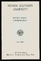
Nevada Southern University 2nd commencement program
Date
1965-06-14
Archival Collection
Description
Commencement program from University of Nevada, Las Vegas Commencement Programs and Graduation Lists (UA-00115).
Text
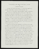
"The Evolution of a Black Community in Las Vegas: 1905-1940": manuscript draft by Roosevelt Fitzgerald
Date
1970 (year approximate) to 1996 (year approximate)
Archival Collection
Description
From the Roosevelt Fitzgerald Professional Papers (MS-01082) -- Unpublished manuscripts file.
Text
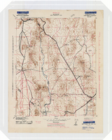
Topographic map of the Camp Mohave quadrangle in California, Nevada and Arizona, 1942
Date
1942
Description
Scale 1;250,000 ; polyconic projection (W 115°--W 114V/N 36V--N 35V) ; 1 map : col. ; 52 x 37 cm ; Relief shown by contours and spot heights. Contour interval 250 feet ; "Training map"--Center of upper margin of map ; "Base compiled from U.S. Geological Survey quadrangles. Control from U.S. Geological Survey. Revised from state highway maps for Arizona, Nevada and California" ; "Culture revisions shown in red based on reconnaissance by 67th Engr. Co. (Top.). May not be of same accuracy as base map." ; Map shows roads, trails, ponton sites, dam sites, possible air fields, possible landing fields, airports, water points, and impassable areas ; Map was originally restricted. "Classification cancelled by authority of Chief of Engineers letter of Jan. 22, 1946." ; Title at top of map: Nevada-Arizona-California : Camp Mohave quadrangle : grid zone F ; Army Map Service, U.S. Army.
Image

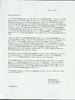
Blueprint map showing proposed new 12" well and pipe line changes at water springs, Las Vegas, Nevada, circa 1920
Date
1916 to 1925
Archival Collection
Description
Stamped : 'Approved (Signed) A. Maguire, Assistant Chief Engineer.' In lower right corner: '6-W-74.' Some annotations written over in yellow; black dotted line added between forebay and final spring in the northwest. Scale [ca. 1:6,000] 1 in.=500 feet
Image