Search Results
Alpha Kappa Alpha Sorority, Theta Theta Omega Chapter program committee reports
Date
Archival Collection
Description
From the Alpha Kappa Alpha Sorority, Incorporated, Theta Theta Omega Chapter Records (MS-01014) -- Chapter records file.
Text
University of Nevada, Las Vegas (UNLV) 2020 and 2021 graduate college commencement program
Date
Archival Collection
Description
Commencement program from University of Nevada, Las Vegas Commencement Programs and Graduation Lists (UA-00115).
Text
Edward C. Light Schematic Drawings of the Hughes H-4 Hercules "Spruce Goose" Seaplane
Identifier
Abstract
The Edward C. Light Schematic Drawings of the Hughes H-4 Hercules "Spruce Goose" Seaplane consists of blueline print reproductions of sheets created between 1941 and 1950 containing schematic engineering design drawings pertaining to the aircraft's rudder and flight control system assembly and installation. Types of drawings include full body perspective diagrams, structural sections, elevations, and plans.
Archival Collection
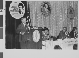
Photograph of Mayor Oran K, Gragson speaking at the pre-telethon production meeting, Las Vegas, Nevada, 1974
Date
Archival Collection
Description
Image
Scott Henry Photographs of the Las Vegas, Nevada Latinx Community
Identifier
Abstract
The Scott Henry Photographs of the Las Vegas, Latinx Community (approximately 1983-2000) consist of 42 photographic prints depicting members of the Latinx community in Las Vegas, Nevada. Thirty-eight of the prints were used as part of a collaborative project between Scott Henry, photographer and editor for the Las Vegas Review-Journal, and Thomas Rodriguez, a prominent member of the Latinx community in Las Vegas, for an exhibit of the Las Vegas Latinx community. Henry and Rodriguez together planned who to photograph for the exhibit. The photographs demonstrate the impact that the Latinx community has on the region's political, economic, and social growth and development. A number of the photographs show early members of the League of United Latin American Citizens (LULAC), including John Mendoza, Delia Martinez, Tom Rodriguez, Bob Agonia, Corrine Gutierrez, Nick Flores, Grace Salazar, and Gus Ramos.
Archival Collection
James B. McDaniel Architectural Records
Identifier
Abstract
The James B. McDaniel Records (1960-1978) comprise the plans and drawings created by Las Vegas, Nevada architect James McDaniel who worked independently as James Brooks McDaniel Architect (from 1960-1978) and with a partner as Moffitt and McDaniel Architects, Limited (during the 1970s). This collection includes materials from over 115 projects managed by McDaniel. Records include oversized architectural drawings, and files of architectural projects. McDaniel designed many University of Nevada, Las Vegas (UNLV) buildings, residential, commercial, and landscape designs for Las Vegas clients. Also included are business files of construction estimates, specifications, invoices, change orders, and correspondence.
Archival Collection
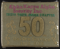
Alpha Kappa Alpha Sorority, Theta Theta Omega Chapter scrapbook: "50 years of golden service"
Date
Archival Collection
Description
From the Alpha Kappa Alpha Sorority, Incorporated, Theta Theta Omega Chapter Records (MS-01014).
Mixed Content
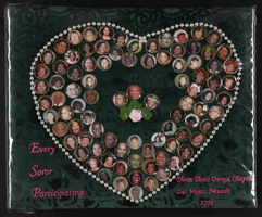
Alpha Kappa Alpha Sorority, Theta Theta Omega Chapter scrapbook: "Every soror participating"
Date
Archival Collection
Description
From the Alpha Kappa Alpha Sorority, Incorporated, Theta Theta Omega Chapter Records (MS-01014).
Mixed Content
Ponderosa Motel (American Inn Motel) Neon Survey document, September 16, 2017
Date
Archival Collection
Description
Site address: 3325 Fremont St
Sign owner: American Inn Motel LLC
Sign details: This location has been around since 1968, but mid-2016 it was renovated from the Ponderosa Inn Motel to the American Inn Motel but they use the same sign that was slightly redesigned for their use.
Sign condition: 5- very good condition and shines brightly at night
Sign form: Pylon
Sign-specific description: This pylon sign has a red steel beam base that has a reader board on the bottom portion of the sign. Above the reader board spells out "MOTEL" vertically in white Frontier font letters, with each letter in its own red square. Each letter of this is outlined in red skeletal neon. Above this is a rectangular plastic back lit sign (used to say Ponderosa on it) that now currently has the American Inn logo in it with white letters but a red and blue background. The whole sign is outlined in chasing incandescent light bulbs.
Sign - type of display: Neon, incandescent and plastic back lit sign
Sign - media: Steel and plastic
Sign - non-neon treatments: Plastic back lit portion
Sign animation: Incandescent light bulbs chasing all around the sign.
Sign environment: This property is very east on Fremont in between St. Louis street and Sahara. There are also many other motels and apartments surrounding this property. This motel is right next door to the Lucky Cuss Motel (their old sign is now one of the restored signs in the Las Vegas Signs project showcases on Las Vegas Blvd.).
Sign - date of installation: Has been up since around 2011
Sign - date of redesign/move: 2016 the plastic portion of the sign was swapped out from the Ponderosa motel sign and the American Inn sign that is currently there now.
Sign - thematic influences: The big MOTEL portion of this sign was very prominent on motel signs in the 50's/60's, such as the La Concha and Tam O' Shanter Motel signs.
Sign - artistic significance: Font was an old west Frontier font which was prominently popular in Las Vegas in the 1940's but has been recreated many times throughout Vegas history.
Survey - research locations: Booking.com website has information on the American Inn Motel https://www.booking.com/hotel/us/ponderosa-motel-las-vegas.html , google map sattelite view, Asessor's page
Survey - research notes: When trying to search Ponderosa Motel on google is when it was discovered that it has switched over to the American Inn motel, but google maps helped with dating when the switch occurred.
Surveyor: Emily Fellmer
Survey - date completed: 2017-09-16
Sign keywords: Neon; Incandescent; Plastic; Backlit; Steel; Chasing; Pole sign; Reader board
Text
Edythe and Lloyd Katz Papers
Identifier
Abstract
The Edythe and Lloyd Katz papers (1934-2002) provide a glimpse of the social, religious, and educational contributions they made to the community of Las Vegas, Nevada. Materials include photographs, correspondence, newspaper clippings, and awards dating from 1934 to 2002.
Archival Collection