
Search the Special Collections and Archives Portal

Search Results

Display    Results Per Page
Displaying results 55991 - 56000 of 57586

Juanita Greer White Papers

Identifier

MS-00254

Abstract

The collection is comprised of the personal, professional and business papers of Dr. Juanita Greer White from 1927 to 1980. Included are correspondence, booklets, dissertations, minutes, newsletters, newspaper clippings, and various other materials linked to women's organizations and Nevada organizations relating to education, health, and aging. Other material includes documents from her work in the Nevada State Legislature, books, catalogs, chemistry papers, plaques, and campaign materials.

Archival Collection

Foley, Roger Drummond, 1917-1996

Roger Drummond Foley (1917-1996) was Nevada’s 23rd Attorney General and was nominated to the federal United States District Court, District of Nevada by President John F. Kennedy in 1962. A few of Foley’s famous cases during his tenure included the radiation exposure of the “Baneberry” Nuclear Test and the protection of the Ash Meadows Desert Pupfish in United States v. Francis Leo Cappaert.

Person

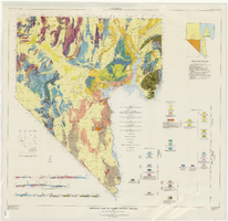
Geologic map of Clark County, Nevada, 1964

Date

1964

Description

'By C.R. Longwell, E.H. Pampeyan, and Ben Bowyer.' 'Prepared cooperatively by the U.S. Geological Survey.' 'Topographic base from Army Map Service Kingman (1947) and Las Vegas (1953) two-degree quadrangle. More recent editions were published after geological compilation and are used on Plate 2.' 'Geology compiled 1955 with revisions and additons to 1964.' At top of map: 'Nevada Bureau of Mines. Bulletin 62, Plate 1.' Published by Williams & Heintz Map Corp. Scale 1:250,000. Bulletin (Nevada Bureau of Mines)62. Relief shown by contours and spot heights. Includes two index maps and eight cross-sections.

Image

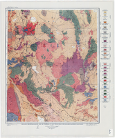
Geologic reconnaissance map of portions of southwestern Nevada and eastern California, 1905

Date

1905

Description

At top of map: 'U.S. Geological Survey, Charles D. Walcott, director.' At bottom of map: 'E.M. Douglas, Geographer. R.H. Chapman, in charge of section.Triangulation and topography by R.H. Chapman and B.D. Stewart. Surveyed in 1905.' 'Geology by Sydney H. Ball. Geology in immediate vicinity of Goldfield and Bullfrog generalized from maps by F.L. Ransome assisted by George H. Garrey and W.H. Emmons.' Scale 1:250,000 (W 117°30--W 116°/N 38°--N 36°)

Image

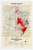
Map showing home-site lands in the Las Vegas Valley, 1955

Date

1955

Description

Scale [1:84,269. 1 in. to 1 1/3 miles] ; 1 map : col. ; 57 x 50 cm. on sheet 89 x 59 cm ; Cadastral map ; Gives definition of township, section and acre ; Relief shown by form lines and spot heights ; Shows private land, land classified for small tracts, leased land, vacant Federal land, section numbers, number of acres in each homesite and purchase price of tract ; "From your Congressman Cliff Young."--stamped on map ; Southern Nevada Home-Siters

Image

Topographic map of the northeast quadrangle of the metropolitan Las Vegas, Nevada area, 1967

Date

1967

Description

Scale 1:24,000 ; polyconic proj. (W 115°730--W 115°0000/N 36°1500--N 36°730) ; 1 map : col. ; 58 x 47 cm ; 7.5 minute series (topographic) ; Relief shown by contours and spot heights ; Filing title: Las Vegas NE, Nev ; "AMS 2956 II NE--Series V896." ; Contour interval 20 feet ; "Topography by photogrammetric methods from aerial photographs taken 1965. Field checked 1967." ;Includes quadrangle location map ; Interior--Geological Survey

Image

Topographic map of the northeast quadrangle of the metropolitan Las Vegas, Nevada area, 1973

Date

1973

Description

Scale 1:24,000 ; polyconic proj. (W 115°730--W 115°0000/N 36°1500--N 36°730) ; 1 map : col. ; 58 x 47 cm ; 7.5 minute series (topographic) ; Relief shown by contours and spot heights ; "AMS 2956 II NE--Series V896." ; Contour interval 20 feet ; "Topography by photogrammetric methods from aerial photographs taken 1965. Field checked 1967." ; "Revisions shown in purple compiled from aerial photographs taken 1973. This information not field checked." ; Includes quadrangle location map ; Filing title: Las Vegas, NE, Nev ; Interior--Geological Survey

Image

Topographic map of the northwest quadrangle of the metropolitan Las Vegas, Nevada area, 1967

Date

1967

Description

Scale 1:24,000 ; polyconic proj. (W 115°1500--W 115°730/N 36°1500--N 36°730) ; 1 map : col. ; 58 x 47 cm ; 7.5 minute series (topographic) ; Relief shown by contours and spot heights ; Filing title: Las Vegas NW, Nev ; "AMS 2956 II NW--Series V896." ; Contour interval 10 feet ; "Topography by photogrammetric methods from aerial photographs taken 1965. Field checked 1967." ; Includes quadrangle location map ; Interior--Geological Survey

Image