Search Results


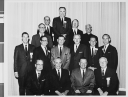
Photograph of Mayor Oran K. Gragson and other attendees of the International Exposition of Flight and General Aviation Conference, circa 1960s
Date
1960 to 1969
Archival Collection
Description
Attendees of the International Exposition of Flight and General Aviation Conference. Pictured are: Front row, L-R: U. S. Nevada Senator Alan Bible, Las Vegas Mayor Oran K. Gragson, U. S. Nevada Senator Howard Cannon. Some of the men have a ribbon attached to their badge that reads "IEF." The location where the photograph was taken is unknown. Oran Kenneth Gragson (February 14, 1911 – October 7, 2002) was an American businessman and politician. He was the longest-serving mayor of Las Vegas, Nevada, from 1959 to 1975. Gragson, a member of the Republican Party, was a small business owner who was elected Mayor on a reform platform against police corruption and for equal opportunity for people of all socio-economic and racial categories. Gragson died in a Las Vegas hospice on October 7, 2002, at the age of 91. The Oran K. Gragson Elementary School located at 555 N. Honolulu Street, Las Vegas, NV 89110 was named in his honor. Howard Walter Cannon (January 26, 1912 – March 5, 2002) was an American politician. He served as a United States Senator from Nevada from 1959 until 1983 as a member of the Democratic Party. In 1956, Cannon ran for the United States House of Representatives to succeed Republican incumbent Clarence Clifton Young, who ran for the U.S. Senate, but lost the Democratic primary to former Congressman Walter Baring, who then won the general election. In 1958, he was elected to the United States Senate, unseating Republican Senator George W. Malone with 58% of the vote.. Cannon was nearly defeated in his first re-election bid in 1964, holding off Republican Lieutenant Governor Paul Laxalt in one of the closest Senate elections ever. Alan Harvey Bible (November 20, 1909 – September 12, 1988) was an American lawyer and politician. A member of the Democratic Party, he served as a United States Senator from Nevada from 1954 to 1974. He previously served as Attorney General of Nevada from 1942 to 1950. In 1952, Bible was narrowly defeated for the Democratic nomination for the United States Senate, losing to political newcomer Thomas B. Mechling by 475 votes. However, after the death of Senator McCarran in September 1954, Bible was elected to the Senate the following November to fill the remainder of McCarran's term. He defeated Republican Ernest S. Brown, who had been appointed to McCarran's seat by Governor Charles H. Russell, by a margin of 58%-42%. He was reelected in 1956, 1962, and again in 1968 and represented Nevada in the United States Senate from December 2, 1954, until his resignation on December 17, 1974. During his time in the United States Senate, he was chairman of the Committee on the District of Columbia (Eighty-fifth through Ninetieth Congresses), the Joint Committee on Washington Metropolitan Problems (Eighty-fifth and Eighty-sixth Congresses), and the U.S. Senate Select Committee on Small Business (Ninety-first through Ninety-third Congresses). He is buried in Reno, Nevada.
Image
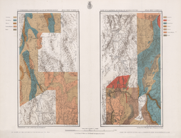
Maps of geographical surveys of parts of California, southeastern Nevada, Arizona and southwestern Utah, made under the command of George M. Wheeler, 1872-1873
Date
1872 to 1873
Description
At top of plate: 'U.S. geographical surveys west of the one-hundredth meridian. Parts of California, S.E. Nevada, Arizona & S.W. Utah.' At bottom of plate: 'Expeditions of 1872 & 1873, under the command of 1st Lieut. Geo. M. Wheeler, Corps of Engineers, U.S. Army.' 'G. K. Gilbert, A. R. Marvine, E. E. Howell, geological assistants.' 'By order of The Honorable The Secretary of War, under the direction of Brig. Gen. A. A. Humphries, Chief of Engineers, U.S. Army.' Published by Government Printing Office. 2 map sections on 1 sheet. Scale: 1 inch to 8 miles.
Image
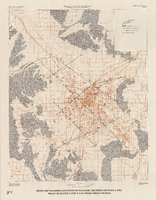
Index map showing locations of geologic sections on plate 2 and wells on plates 2 and 3, Las Vegas Valley, Nevada, 1981 (Water-supply paper 2320-A)
Date
1981
Description
'Department of the Interior, U.S. Geological Survey. Water-supply paper 2320-a, plate 4.' 'Prepared in cooperation with the Clark County Department of Comprehensive Planning.' 'Base from U.S. Geological Survey 1:100,000 , Boulder City, Ariz.-Nev., Las Vegas, Nev.-Calif., Mesquite Lake, Nev.-Calif., 1978, Lake Mead, Nev.-Ariz., 1979.' 'Geology from Malmberg (1965); Longwell and others (1965); Bell and Smith (1980); and J. R. Harrill, 1976.' Shows township and range lines. Scale 1:100,000 (W 115°30´--W 115°00´/N 36°30´--N 36°00´). Series: U.S. Geological Survey water-supply paper2320-A. Originally published as plate 4 of Ground-water conditions in Las Vegas Valley, Clark County, Nevada. Part I. Hydrogeologic framework / by Russell W. Plume, published by the U.S. Geological Survey in 1989 as Water-supply paper 2320-A.
Image
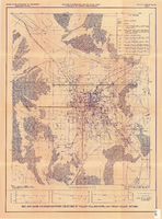
Map and basin profiles showing thickness of valley-fill deposits, Las Vegas Valley, Nevada, 1981
Date
1981
Description
At top of map: 'United States Department of the Interior. Geological Survey. Open-file report 84-130, plate 5.' 'Prepared in cooperation with the Clark County Department of Comprehensive Planning.' At bottom of map: 'Base from U.S. Geological Survey, 1:100,000, Boulder City, Ariz.-Nev., Las Vegas, Nev.-Calif., Mesquite Lake, Nev.-Calif., 1978; Lake Mead, Nev.-Ariz., 1979.' 'Geology from Malmberg (1965); Longwell and others (1965); Haynes (1967); Bell and Smith (1980); Bell (1981) and J. R. Harrill, 1976. Thickness of valley-fill deposits by R.W. Plume, 1981.' Includes three profiles. Shows township and range lines. Scale [ca. 1:95.040. 1 in.=approx. 1.5 miles] (W 115°30´--W 115°00´/N 36°30´--N 36°00´). Series: Open-file report (Geological Survey (U.S.)), 84-130. Originally published as plate 5 of Ground-water conditions in Las Vegas Valley, Clark County, Nevada. Part I. Hydrogeologic framework / by Russell W. Plume, published by the U.S. Geological Survey in 1984 as Open-file report 84-130.
Image
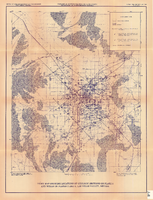
Index map showing locations of geologic sections on plate 2 and wells on plates 2 and 3, Las Vegas Valley, Nevada, 1981 (Open-file report 84-130)
Date
1981
Description
'United States Department of the Interior, Geological Survey. Open-file report 84-130, plate 4.' 'Prepared in cooperation with the Clark County Department of Comprehensive Planning.' 'Base from U.S. Geological Survey 1:100,000 , Boulder City, Ariz.-Nev., Las Vegas, Nev.-Calif., Mesquite Lake, Nev.-Calif., 1978, Lake Mead, Nev.-Ariz., 1979.' Geology from Malmberg (1965); Longwell and others (1965); Bell and Smith (1980); and J. R. Harrill, 1979.' Shows township and range lines. Scale [ca. 1:95.040. 1 in.=approx. 1.5 miles] (W 115°30´--W 115°00´/N 36°30´--N 36°00´). . Series: Open-file report (Geological Survey (U.S.))84-130. Originally published as plate 4 of Ground-water conditions in Las Vegas Valley, Clark County, Nevada. Part I. Hydrogeologic framework / by Russell W. Plume, published by the U.S. Geological Survey in 1984 as Open-file report 84-130.
Image