Search Results
Letter from McCartney to Clark, January 16, 1902
Date
1902-01-16
Archival Collection
Description
Letter relates a letter from Helen J. Stewart and discusses the possibility of artesian water sources in Las Vegas. It also identifies possible crops that could grow in Las Vegas and gives suggestions for purchasing land in the area.
Text
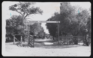
Entrance to the Pahrump Valley Hotel: photographic print
Date
1916
Archival Collection
Description
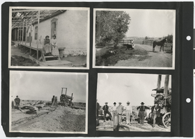
Entrance gate to Pahrump Valley Company which includes the hotel, ranch, school, homes, etc in 1916. Notice water flowing across road; it was from an artesian well and was used for irrigation. Handwritten inscription on back of photo reads, "1916 entrance gate to Pahrump Valley Compny Ranch,Store, School; hotel, boarding house, bunk house, blacksmith shop, duplex homes, implement shed, home of ranch foreman. Notoce water flowingacross the road. From the spring, pools artesian well across corrall & fields where it was ditched for irrigation." It also has this stamp on the back, Pahrump Tribune P. O. Box218A Pahrump, NV 89041.
Image