Search Results

Geologic map of the Tippipah Spring quadrangle, Nye County, Nevada, 1963
Date
1963
Description
58 x 46 cm., on sheet 84 x 81 cm., folded in envelope 30 x 24 cm. Relief shown by contours and spot heights. "Geology by P.P. Orkild, 1959-60, paleotopography by D.L. Healey and C.H. Miller, 1959-60." Series statement from envelope. Includes description of map units, 2 col. cross sections, and quadrangle location map. "Prepared in cooperation with the U. S. Atomic Commission." Original publisher: Interior, Geological Survey, Series: Geologic quadrangle map GQ, Scale: 1:24 000.
Image

Geologic map of the Jangle Ridge quadrangle, Nye and Lincoln Counties, Nevada, 1965
Date
1965
Description
58 x 46 cm., on sheet 84 x 87 cm., folded in envelope 30 x 24 cm. Relief shown by contours and spot heights. "Contour interval 20 feet." "Prepared in cooperation with the U.S. Atomic Energy Commission." "Geology mapped in 1961. Limit of pluvial Groom Lake and faults from photographs mapped by R. B. Colton, 1962." Includes text, bibliography, location map, and 5 col. cross sections. Original publisher: Interior, U.S. Geological Survey, Series: Geologic quadrangle map GQ, Scale: 1:24 000.
Image
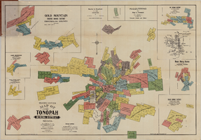
Map of the Tonopah Mining District, Tonopah (Nev.), 1903
Date
1903
Description
Rev. ed. ; Scale [ca. 1:10,800]. 1 inch to 900 feet ; 1 map : col. ; 76 x 102 cm., folded in cover to 21 x 11 cm ; Relief shown by hachures ; Cover title: Map of Tonopah, Gold Mountain and other adjacent mining districts, Nye and Esmeralda Counties ; Insets: Ray Mining District, vicinity map of Tonopah Mining District, Utopia Mining District, Tokop Mining District, Weepah Mining District, East Klondike Mining District, Gold Mountain, Tonopah Mining District and Red Mountain ; "Photo-lith. Britton & Rey, S.F." ; Includes advertisements
Image
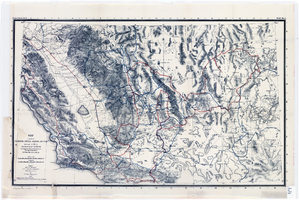
Map of parts of California, Nevada, Arizona and Utah : traversed in 1891 by the Death Valley Expedition (a biological survey conducted by the U.S. Dept. of Agriculture), C. Hart Merriam in charge
Date
1893
Description
Scale [ca. 1:1,267,200. 1 in. to approx. 20 miles] (W 122°00--W 113°00/N 38°30--N 34°00) ; 1 map : col. ; 42 x 69 cm., folded to 22 x 12 cm ; Relief shown by hachures and spot heights ; From: The Death Valley Expedition. Part II. 1893. North American fauna, no. 7 ; "Routes of Dr. C. Hart Merriam" and "Distinctive routes of other members of the expedition" overprinted in color ; Map was compiled in 1892 ; "Map no. 1."--Upper right corner ; Government Printing Office
Image
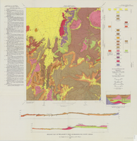
Geologic map of the Quartet Dome quadrangle, Nye County, Nevada, 1966
Date
1966
Description
58 x 46 cm., on sheet 88 x 85 cm., folded in envelope 30 x 24 cm. Relief shown by contours and spot heights. "Contour interval 20 feet." "Base by U.S. Geological Survey, 1962, 10,000-foot grid based on Nevada coordinate system, central zone." "Geology mapped in 1962-63." Includes 2 col. cross sections, diagrammetric stratigraphic section, quadrangle location map, and text. "Prepared in cooperation with the U.S. Atomic Energy Commission." Original publisher: Interior, Geological Survey, Series: Geologic quadrangle map GQ, Scale: 1:24 000.
Image
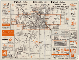
Las Vegas area map, 1960
Date
1960
Description
1960 ed. Scale [ca. 1:47,520. 1 in. equals approx. 0.75 miles.] 1 map : col. ; 41 x 43 cm., folded to 22 x 10 cm. Panel title: Welcome map : greater Las Vegas area and scenic routes to and from there. "1960-61 edition."--Panel. Irregularly-shaped map. Includes list of Las Vegas schools, inset maps of East Las Vegas (Whitney) and Wherry housing area on Nellis Air Force Base and advertisements for Las Vegas businesses. Index, mileages from cities in the United States to Las Vegas and sightseeing information on verso. Library's copy 1 has some art work and some lettering in orange and has "Las Vegas Nevada Chamber of Commerce" stamped in purple on panel. Library's copy 2 has some art work and some lettering in purple and has "Pioneer Title Insurance Co. of Nevada" stamped in black on panel. Nevada State Motel Association?
Text