Search the Special Collections and Archives Portal
Search Results

A hand painted bird house at the Las Vegas Community Healing Garden, looking north-northeast in Las Vegas, Nevada: digital photograph
Date
Archival Collection
Description
Following the October 1, 2017 killing of 58 people at the Route 91 Harvest Music Festival on the Las Vegas Strip, the Las Vegas community responded in a variety of ways. Envisioned by activists and built by volunteers, the City of Las Vegas established the Las Vegas Community Healing Garden at 1015 S. Casino Center Boulevard to honor the victims and give family members and the community a place to gather to remember.
Image

The "Vegas Strong" heart sculpture along the walkway at the Las Vegas Community Healing Garden, looking south-southeast in Las Vegas, Nevada: digital photograph
Date
Archival Collection
Description
Following the October 1, 2017 killing of 58 people at the Route 91 Harvest Music Festival on the Las Vegas Strip, the Las Vegas community responded in a variety of ways. Envisioned by activists and built by volunteers, the City of Las Vegas established the Las Vegas Community Healing Garden at 1015 S. Casino Center Boulevard to honor the victims and give family members and the community a place to gather to remember.
Image

A box containing inscribed rocks for family members sits along the walkway at the Las Vegas Community Healing Garden, looking south in Las Vegas, Nevada: digital photograph
Date
Archival Collection
Description
Following the October 1, 2017 killing of 58 people at the Route 91 Harvest Music Festival on the Las Vegas Strip, the Las Vegas community responded in a variety of ways. Envisioned by activists and built by volunteers, the City of Las Vegas established the Las Vegas Community Healing Garden at 1015 S. Casino Center Boulevard to honor the victims and give family members and the community a place to gather to remember.
Image
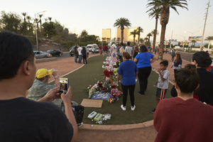
A man uses his cell phone camera to photograph as people gather at the 1 October memorial located at the Welcome to Las Vegas sign, looking north-west in Las Vegas, Nevada: digital photograph
Date
Archival Collection
Description
Following the October 1, 2017 killing of 58 people at the Route 91 Harvest Music Festival on the Las Vegas Strip, the Las Vegas community responded in a variety of ways. This series of photographs document the impromptu memorial created at the Welcome to Las Vegas sign.
Image
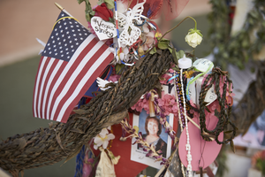
Items, including a ti leaf lei from Hawaii, left at the 1 October memorial located at the Welcome to Las Vegas sign cover a cross, looking west-northwest in Las Vegas, Nevada: digital photograph
Date
Archival Collection
Description
Following the October 1, 2017 killing of 58 people at the Route 91 Harvest Music Festival on the Las Vegas Strip, the Las Vegas community responded in a variety of ways. This series of photographs document the impromptu memorial created at the Welcome to Las Vegas sign.
Image

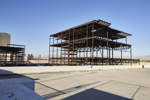
A stand alone building on the back side of the Resorts World Las Vegas tower under construction as seen from the Circus Circus parking garage, looking west-southwest in Las Vegas, Nevada: digital photograph
Date
Archival Collection
Description
Photographed as part of the UNLV Special Collections and Archives' Building Las Vegas collecting initiative started in 2016. This photo series documents ongoing construction work at the Resorts World Las Vegas site.
Image
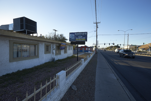
Much of the residential housing along this section of Civic Center Drive has been converted into business space, looking south in North Las Vegas, Nevada: digital photograph
Date
Archival Collection
Description
From the UNLV University Libraries Photographs of the Development of the Las Vegas Valley, Nevada (PH-00394). Part of the collection documents the entire 19 mile length of the north/south Eastern Avenue / Civic Center Drive alignment. This photograph was captured in the section of Civic Center Drive and Eastern Avenue between Lake Mead Boulevard and Washington Avenue.
Image

A Church of Jesus Christ of Latter-day Saints at the corner of Civic Center Drive and Tonopah Avenue, looking south in North Las Vegas, Nevada: digital photograph
Date
Archival Collection
Description
From the UNLV University Libraries Photographs of the Development of the Las Vegas Valley, Nevada (PH-00394). Part of the collection documents the entire 19 mile length of the north/south Eastern Avenue / Civic Center Drive alignment. This photograph was captured in the section of Civic Center Drive and Eastern Avenue between Lake Mead Boulevard and Washington Avenue.
Image
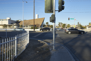
A Church of Jesus Christ of Latter-day Saints at the corner of Civic Center Drive and Tonopah Avenue, looking south in North Las Vegas, Nevada: digital photograph
Date
Archival Collection
Description
From the UNLV University Libraries Photographs of the Development of the Las Vegas Valley, Nevada (PH-00394). Part of the collection documents the entire 19 mile length of the north/south Eastern Avenue / Civic Center Drive alignment. This photograph was captured in the section of Civic Center Drive and Eastern Avenue between Lake Mead Boulevard and Washington Avenue.
Image
