Search Results
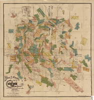
Elmer J. Chute's Map of Goldfield Mining District, Esmeralda and Nye Counties (Nev.), 1905
Date
1905
Description
Scale [ca. 1:20, 400. 1 in.=aprrox. 1,700 feet] ; 1 map : col. ; 60 x 58 cm ; Includes inset location map ; Includes township and range grid ;
Image

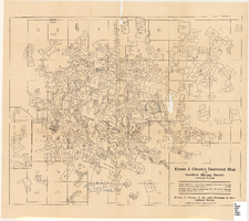
Elmer J. Chute's map of U.S. patent and location surveys in the Goldfield Mining District, Esmeralda and Nye Counties (Nev.), 1907
Date
1907
Description
Scale [ca. 1:22,800. 1 in. to approx. 1900 feet] ; 1 map : col. ; 66 x 82 cm., folded to 18 x 9 cm ; Includes index Includes township and range grid ;
Image
Elmer J. Chute's Diamond Map of the Goldfield Mining District, Esmeralda and Nye Counties (Nev.), 1907
Date
1907
Description
Elmer J. Chute's Diamond Map of the Goldfield Mining District, Esmeralda and Nye Counties (Nev.), 1907
Image

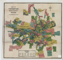
Map of the Tonopah Mining District, Nye County (Nev.), 1905
Date
1905
Description
Scale [ca.1:12,804. 1 in. to approx. 1,067 ft.] ; 1 map ; on sheet 92 x 106 cm ; Relief shown by hachures ; Title supplied by cataloger ; Probably a preliminary black and white edition of the colored map copyrighted by Bradford and Bradford in 1905
Image
Map of the Tonopah Mining District, Nye County (Nev.), 1905
Date
1905
Description
Scale [ca. 1:15,600. 1 in. to approx. 1300 feet] ; 1 map : col. ; 60 x 64 cm ; Relief shown by hachures ; Copyright held by Bradford & Bradford ; Includes table of distances ; Library's copy has one section outlined in red pencil and Tonopah Victor printed on it in red pencil. Red pencil dots are on two other sections. 1905 printed in pencil and some unreadable words written in pencil near title of map ;
Image
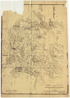
Map of approved mineral surveys in the Goldfield Mining District, Goldfield (Nev.), 1908
Date
1908
Description
Scale [ca. 1:9,600]. 1 in. to 800 feet. (W 117 14'--W 117 09'/N 37 46'--N 37 41') ; 1 map ; 129 x 97 cm ; Blueline print ; Includes township and range grid ; "Copyright 1908 by Davis and Byler. 1911." ; Library's copy has upper-left corner torn off and has circles drawn around and diagonal lines drawn on certain claims ;
Image
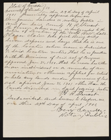
Notarized placer claim
Date
1901-04-29
Archival Collection
Description
This folder is from "Legal Records" file of the Sadie and Hampton George Papers (MS-00434)
Text
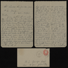
Correspondence, E.H. Syphus to H.E. George
Date
1902-01-26
Archival Collection
Description
This folder is from the "Correspondence" file of the Sadie and Hampton George Papers (MS-00434)
Text
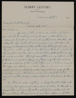
Correspondence, Levi Syphus to Sadie George
Date
1910-10
Archival Collection
Description
This folder is from the "Correspondence" file of the Sadie and Hampton George Papers (MS-00434)
Text
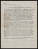
Report from U.S. Geological Survey on pottery
Date
1912
Archival Collection
Description
This folder is from "Maps and Assorted Documents" file of the Sadie and Hampton George Papers (MS-00434)
Text