Search Results
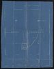
Map of Sadie B. George property
Date
1874 to 1944
Archival Collection
Description
This folder is from "Maps and Assorted Documents" file of the Sadie and Hampton George Papers (MS-00434)
Text
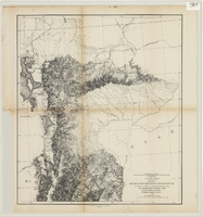
Maps of explorations and surveys for a railroad route from the Mississippi River to the Pacific Ocean, 1855
Date
1855
Description
Map no. 1. From the valley of Green River to the Great Salt Lake -- Map no. 2. From the Great Salt Lake to the Humboldt Mountains -- Map no. 3. From the Humboldt Mountains to the Mud Lakes -- Map no. 4. From the valley of the Mud Lakes to the Pacific Ocean. 'From explorations and surveys made under the direction of the Hon. Jefferson Davis, Secretary of War, by Capt. E.G. Beckwith, 3rd Artillery, E.G. Egloffstein, topographer for the route. 1855.' ''Selmar Siebert's Engraving & Printing Establishment, Washington, D.C.' Published by the War Dept. Scale 1:760,320. 12 miles to 1 in. Relief shown by hachures and spot heights.
Image
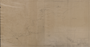
Map of general plan for the Wells Siding Project in Logandale, Nevada, May 15, 1935
Date
1935-05-15
Archival Collection
Description
'U.S. Department of Agriculture, Forest Service, Camp P.E. 206.' 'By C.C.C. Company, 538. Drawn by Ed Overton. Approved ... 5-15-35.Traced by Ed Overton.'
Image
Report on floods from the Meadow Valley Wash, Muddy River, and California Wash, after 1945
Date
1945 to open end
Archival Collection
Description
List of major floods in the Moapa Valley with accompanying map.
Text
Petition by property owners to create the Las Vegas Valley Water District addressed to the Board of Commissioners, Clark County, Nevada, after 1947
Date
1947 to open end
Archival Collection
Description
Text of the petition circulated to real property owners within Clark County to create the Las Vegas Valley Water District. Also included is a map of the area to be supplied with water, which is marked with the proposed boundaries of seven divisions.
Text
Water bearing lands owned by UPRR prints
Date
1952
Archival Collection
Description
Water bearing lands owned by UPRR prints
Mixed Content
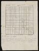
Plot map, Township No. 14S, Range No. 65E
Date
1874 to 1944
Archival Collection
Description
This folder is from "Maps and Assorted Documents" file of the Sadie and Hampton George Papers (MS-00434)
Text
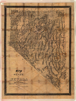
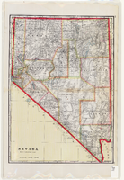
Map of the state of Nevada, 1886
Date
1886
Description
'Compiled by John W. Parker, chief draughtsman of the U.S. Sur. General's Office, Reno, Nevada, from official maps on file on the office, War Department maps and other reliable data. 1886.' 'Entered according to act of Congress, in the year 1886, by John W. Parker, in the office of the Librarian of Congress at Washington.' Relief shown by hachures. Shows townships, including which townships are subdivided, roads, railroads, Indian reservations, etc. Shows range and township grid. Scale [1:760,320]. 1 in. to 12 miles (W 120°--W 114°/N 42°--N 35°).
Image
Map of Nevada, circa 1909
Date
1907 to 1911
Description
'Geo. F. Cram, engraver and publisher.' Scale [ca. 1:1,584,000. 1 in. to approx. 25 miles] (W 120°--W 114°/N 42°--N 35°). Relief shown by hachures and spot heights. Counties outlined in color. Shows railroads, forest reserves, mines, Indian reservations, and springs. Shows range and township grid. Indexes on verso to both Nevada and Utah maps. Atlas p. numbers in right margin: 124-125. G.F. Cram.
Text
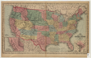
Map of the United States of America, 1859
Date
1859
Description
'Philadelphia. Published by Charles Desilver ... 1859.' Entered according to Act of Congress in the year 1856 by Charles Desilver in the Clerks office of the District Court of the Eastern District of Pennsylvania.' 'Engraved by J.L. Hazzard & E. Yeager.' Includes notes and insets titled 'Gold region of California' and 'District of Columbia.' Relief shown by hachures and spot heights. Also shows battle fields and proposed western railroad routes. Prime meridians: Washington and Greenwich. Atlas p. numbers in upper margin: 5-6. Scale 1:8,750,000 (W 126°--W 65°/N 48°--N 24°)
Image