Search Results
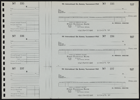
Measurement of wells and springs, June 14, 1935
Date
Archival Collection
Description
Measurement of the flow from the Las Vegas Land and Water Co. wells and springs on June 14, 1935
Text
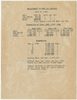
Mandalay Bay can be seen through a gate where flowers and name tags honoring the 58 people who were killed during a 2017 mass shooting were placed at the Route 91 Harvest Festival grounds, looking southwest, Las Vegas, Nevada: digital photograph
Date
Archival Collection
Description
Following the October 1, 2017 killing of 58 people at the Route 91 Harvest Music Festival on the Las Vegas Strip, the Las Vegas community responded in a variety of ways. To honor the second anniversary of the shooting, various items were left at the site.
Image
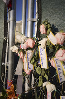
Photograph of the Hippodrome theater, Goldfield (Nev.), 1900-1920
Date
Archival Collection
Description
Image
Historic Building Survey Collection
Identifier
Abstract
The Historic Building Survey Collection (1930-2001) contains materials on the preservation of historic buildings in Southern Nevada, Arizona, and Utah from Dr. Ralph Roske's History 117 course taught at the University of Nevada, Las Vegas (UNLV). The collection is comprised of surveys which include descriptions, photographs, blueprints, newspaper clippings, pamplets, and fliers related to historic houses, businesses, and public sites.
Archival Collection
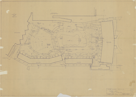
Architectural drawing of Riviera Hotel and Casino (Las Vegas), landscape development, March 12, 1962
Date
Archival Collection
Description
Landscape development construction plan for the expansion of the Riviera in 1962. Facsimile.
Site Name: Riviera Hotel and Casino
Address: 2901 Las Vegas Boulevard South
Image
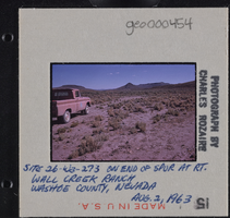
Photographic slide of Wall Creek Ranch, Nevada, August 2, 1963
Date
Archival Collection
Description
Image
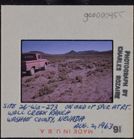
Photographic slide of Wall Creek Ranch, Nevada, August 2, 1963
Date
Archival Collection
Description
Image
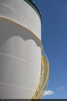
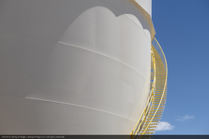
Water tank, Crescent Dunes Solar, near Tonopah, Nevada: digital photograph
Date
Archival Collection
Description
Photographer's assigned keywords: "110 megawatts; CSP; Concentrated Solar Energy; Concentrated Solar Power; Crescent Dunes; NV; Nevada; Solar Reserve; SolarReserve; Tonopah; concentrated solar thermal; green energy; ground-based photo; molten salt; on-site; renewable energy; storage; tower."
Image