Search the Special Collections and Archives Portal
Search Results

Photograph of event hosted by the Jewish Federation of Las Vegas, 1998-2000
Description
Note on reverse: L-R Jay and Roni Epstein, executive director; co-chairs Fran Fine, Paul & Ellen Bodner; Ed Asner, guest speaker; co-chairs Sandy & Marv Snyder; David Dahan, President and Yaffa Dahan
General Land Office Survey Books
Identifier
Abstract
The General Land Office Survey Books (approximately 1881-1919) consist of nine bound volumes of survey maps originally conducted in 1881 by the General Land Office (which later became the U.S. Bureau of Land Management). The primary information shown on the maps is section, township, and range numbers, as well as designation and dimenstions of government lots. The books in this collection cover townships 13 through 32, which includes the majority of Clark County. The secondary information shown on the maps is topographical and geographical in nature, showing mountains, washes, rivers, major wagon roads, and types of vegetation. The hachure lines along section lines indicate mountains and in all probability those lines were not actually walked. Patent application lists are attached to some maps, which also have property owner's name and address. If the patent was granted, the patent number is also shown. If the patent application nwas withdrawn or forfeited, that notation was also noted.
Archival Collection
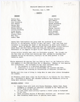
Holocaust Education Committee letters and meeting minutes, document 12
Description
Holocaust Education Committee meeting minutes on June 05, 1980.

