Search the Special Collections and Archives Portal
Search Results

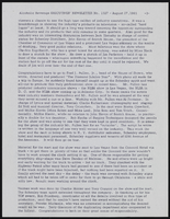
Meeting minutes for Consolidated Student Senate University of Nevada, Las Vegas, April 6, 1989
Date
1989-04-06
Archival Collection
Description
Includes meeting agenda and minutes. CSUN Session 19 Meeting Minutes and Agendas.
Text
Meeting minutes for Consolidated Student Senate, University of Nevada, Las Vegas, March 27, 2006
Date
2006-03-27
Archival Collection
Description
Includes meeting agenda, along with additional information about bills. CSUN Session 36 Meeting Minutes and Agendas.
Text
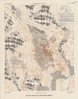
Geologic map of Las Vegas Valley, Nevada, 1982
Date
1982
Description
At top of map:'Department of the Interior, U.S. Geological Survey. Prepared in cooperation with the Clark County Department of Comprehensive Planning. Water supply paper 2320-A, plate 1.' At bottom of map: ' Base from U.S. Geological Survey, 1:100,000, Boulder City, Ariz.-Nev., Las Vegas, Nev.-Calif., Mesquite Lake, Nev.-Calif., 1978; Lake Mead, Nev.-Ariz., 1979. Geology from Malmberg (1965); Longwell and others (1965); Haynes (1967); Bingler (1977); Bell and Smith (1980); Bell (1981); Matti and Bachhuber (1982); and Matti and Morton (1982a, b); modified by R. W. Plume, 1981.' Shows township and range lines. Scale 1:100,000 (W 115°30´--W 115°00´/N 36°30´--N 36°00´). Series: U.S. Geological Survey water-supply paper
2320-A. Originally published as plate 1 of Ground-water conditions in Las Vegas Valley, Clark County, Nevada. Part I. Hydrogeologic framework / by Russell W. Plume, published by the U.S. Geological Survey in 1989 as Water-supply paper 2320-A.
2320-A. Originally published as plate 1 of Ground-water conditions in Las Vegas Valley, Clark County, Nevada. Part I. Hydrogeologic framework / by Russell W. Plume, published by the U.S. Geological Survey in 1989 as Water-supply paper 2320-A.
Image
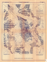
Surficial geologic map of Las Vegas Valley, Nevada, circa 1981
Date
1977 to 1985
Description
'United States Department of the Interior, Geological Survey. Open-file report, 84-130, plate 1.' 'Prepared in cooperation with the Clark County Department of Comprehensive Planning.' 'Base from U.S. Geological Survey 1:100,000, Boulder City, Ariz.-Nev., Las Vegas, Nev.-Calif., Mesquite Lake, Nev.-Calif., 1978, Lake Mead, Nev.-Ariz., 1979.'Geology from Malmberg (1965); Longwell and others (1965); Haynes (1967); Bingler (1977); Bell and Smith (1980); Bell (1981); Matti and Bachhuber (1982); and Matti and Morton (1982a and b); modified by R. W. Plume, 1981.' Shows township and range lines. Scale [ca. 1:102,960. 1 in.=approx. 1.625 miles] (W 115°30´--W 115°00´/N 36°30´--N 36°00´). Series: Open-file report (Geological Survey (U.S.))
84-130. Originally published as plate 1 of Ground-water conditions in Las Vegas Valley, Clark County, Nevada. Part I. Hydrogeologic framework / by Russell W. Plume, published by the U.S. Geological Survey in 1984 as Open-file report 84-130.
84-130. Originally published as plate 1 of Ground-water conditions in Las Vegas Valley, Clark County, Nevada. Part I. Hydrogeologic framework / by Russell W. Plume, published by the U.S. Geological Survey in 1984 as Open-file report 84-130.
Image
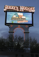
Photographs of Jerry's Nugget Casino sign, Las Vegas (Nev.), March 17, 2017
Date
2017-03-17
2017-07-12
Archival Collection
Description
The Jerry's Nugget Casino sign sits at 1821 North Las Vegas Boulevard. The family-owned and operated casino has been in business for over fifty years. Information about the sign is available in the Southern Nevada Neon Survey Data Sheet.
Site address: 1821 N Las Vegas Blvd
Sign owner: The Stamis Family
Sign details: In 1964, Jerry Stamis and Jerry Lodge opened Jerry's Nugget Casino. The property, formerly the Towne House Bar, was converted into a casino. Four years after its opening, the owners bought the nearby Bonanza Club along with its sign, adding an additional 10,000 square feet to their property. The site has undergone numerous renovations, including in 1982 when it became a full-service casino complete with a restaurant, bars, and nearly 700 slots. The porte cochere was also added at that time. In 1996, a theatre lounge was added as well as a bakery and even more gaming tables. The casino, which celebrated its 50th anniversary in 2014. This location still claims to cater to "locals." Currently, it consists of slots, table games, keno lounge, and a bingo hall, among other popular features.
Sign condition: About 4-5, appears to have relatively low damage
Sign form: Sculptural pylon
Sign-specific description: Neon sign looks to be in the form of an oil derrick, "Jerry's" in a nugget shape at the top, "Nugget" spelled downward in light blue neon, possibly was once orange.
Sign - type of display: Neon
Sign - media: Steel
Sign environment: Located in North Las Vegas along Las Vegas Blvd, near the Silver Nugget Casino.
Sign - date of installation: 1964 for most of the signage for the property
Sign - date of redesign/move: 1982 Porte Cochere added with expansion
Sign - thematic influences: The signage conveys the Old West theme of striking it rich with gold, silver or oil, as they have an oil rig for portion of their sign.
Survey - research locations: Neon Museum tour outline, Jerry's Nugget website http://www.jerrysnugget.com/ , recorder's office, Assessor's page
Survey - research notes: For the 50th anniversary of their Company they donated the money for the restoration of their sign which is showcased on the documentary "Restoration Neon" and remains in the Neon Museum.
Surveyor: Carlyle Constantino
Survey - date completed: 2017-07-12
Sign keywords: Neon; Steel; Pylon; Incandescent; Back to back; Reader board; Video screen
Mixed Content
Pagination
Refine my results
Content Type
Creator or Contributor
Subject
Archival Collection
Digital Project
Resource Type
Year
Material Type
Place
Language
Records Classification

