Search Results

Photograph of Las Vegas Club, Las Vegas (Nev.), 1945-1955
Date
1945 to 1955
Archival Collection
Description
View of Las Vegas Club bar at 18 Fremont St., Las Vegas, Nevada. Site Name: Las Vegas Club (Las Vegas, Nev.)
Image
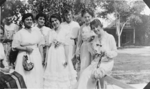
Film transparency of several school teachers, Las Vegas, circa early 1900s
Date
1904 to 1939
Archival Collection
Description
Black and white image of several teachers from Las Vegas schools, including the following (from right to left): Olive Lake, Rose Ullom, Cora Maeble, Dora Lee, and Maude Williams.
Image
Press release by Las Vegas Valley Water District on installation of water meters, October 25, 1955
Date
1955-10-25
Archival Collection
Description
News release by the Las Vegas Valley Water District reporting that they had formally requested the state attorney general to review and state officially the legality of the District's plans to install water meters in Las Vegas. Statement included opinions from the law firm of O'Melveny & Myers and the District General Counsel Leo A. McNamee. Document has stamp of the Union Pacific Rail Road's law department dated October 26, 1955. Also initials stamp by E. E. Bennett dated October 27, 1955.
Text