Search the Special Collections and Archives Portal
Search Results
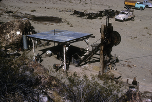
Slide of the old stamp mill, circa 1950s
Date
1950 to 1959
Archival Collection
Description
The old stamp mill, location unknown. A stamp mill (or stamp battery or stamping mill) is a type of mill machine that crushes material by pounding rather than grinding, either for further processing or for extraction of metallic ores. Breaking material down is a type of unit operation. A stamp mill consists of a set of heavy steel (iron-shod wood in some cases) stamps, loosely held vertically in a frame, in which the stamps can slide up and down. They are lifted by cams on a horizontal rotating shaft. On modern mills, the cam is arranged to lift the stamp from the side, so that it causes the stamp to rotate. This evens the wear on the shoe at the foot of the stamp. As the cam moves from under the stamp, the stamp falls onto the ore below, crushing the rock, and the lifting process is repeated at the next pass of the cam. Each one frame and stamp set is sometimes called a "battery" or, confusingly, a "stamp" and mills are sometimes categorized by how many stamps they have, i.e. a "10 stamp mill" has 10 sets. They usually are arranged linearly, but when a mill is enlarged, a new line of them may be constructed rather than extending the line. Abandoned mill sites (as documented by industrial archaeologists) will usually have linear rows of foundation sets as their most prominent visible feature as the overall apparatus can exceed 20 feet in height, requiring large foundations. Stamps are usually arranged in sets of five. Some ore processing applications used large quantities of water so some stamp mills are located near natural or artificial bodies of water. For example, the Redridge Steel Dam was built to supply stamp mills with process water.
Image
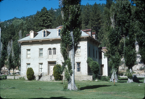
Slide of the Bowers Mansion, Washoe Valley, Nevada, circa 1970s
Date
1970 to 1979
Archival Collection
Description
The Bowers Mansion was built in 1863 by Lemuel "Sandy" Bowers and his wife, Eilley Orrum Bowers, and is a prime example of the homes built in Nevada by the new millionaires of the Comstock Lode mining boom. The mansion, designed by J. Neely Johnson, a builder and ex-governor of California, combined Georgian Revival and Italianate architectural styles. It was modeled after a design conceived by Eilley based on her recollection of elegant buildings in her native Scotland. Following the death of Sandy Bowers in 1868, Eilley fell on hard financial times. She generated income by renting out rooms in the mansion and hosting parties and picnics on the grounds. The mansion hosted a ball for the women's suffrage movement and was the location of the annual Miner's Ball. The period of 1873–75 was the height of the mansion's popularity. However, this was not enough to overcome Eilley's debts and she finally lost her home to foreclosure in 1876. The mansion was abandoned by the time Henry Riter acquired it and operated it as a resort until 1946. The building is currently owned and operated by the Washoe County Parks Department. Some 500 Nevada families have donated period furniture housed in the mansion. The park blends the historical site with recreational facilities such as a spring-fed swimming pool, picnic areas, and a playground. The Bowers Mansion is located in Washoe Valley, within the Bowers Mansion Regional Park at 4005 Old U.S. Highway 395 North, North Washoe Valley, Nevada.
Image
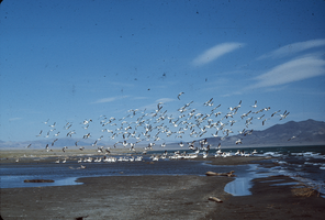
Slide of pelicans at Pyramid Lake, Nevada, circa 1970s
Date
1970 to 1979
Archival Collection
Description
A flock of pelicans at Pyramid Lake, Nevada. Some birds are wading near a sand bar, while others are airborne. Pyramid Lake is the geographic sink of the Truckee River Basin, 40 mi (64 km) northeast of Reno. Pyramid Lake is fed by the Truckee River, which is mostly the outflow from Lake Tahoe. The Truckee River enters Pyramid Lake at its southern end. Pyramid Lake has no outlet, with water leaving only by evaporation, or sub-surface seepage (an endorheic lake). The lake has about 10% of the area of the Great Salt Lake, but it has about 25% more volume. The salinity is approximately 1/6 that of sea water. Although clear Lake Tahoe forms the headwaters that drain to Pyramid Lake, the Truckee River delivers more turbid waters to Pyramid Lake after traversing the steep Sierra terrain and collecting moderately high silt-loaded surface runoff. Pyramid Lake is the site of some of the Earth's most spectacular tufa deposits. Tufa is a rock composed of calcium carbonate (CaCO3) that forms at the mouth of a spring, from lake water, or from a mixture of spring and lake water. The explorer John C. Fremont (1845) wrote about the tufas during his 1843-44 expedition and named the lake after the pyramidal-shaped island that lies along the east shore of the lake. The Paiute name for the island is Wono, meaning cone-shaped basket. The Paiute name for the lake is Cui-Ui Panunadu, meaning fish in standing water.
Image
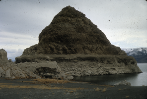
Slide of a tufa deposit in Pyramid Lake, Nevada, circa 1970s
Date
1970 to 1979
Archival Collection
Description
The pyramid-shaped island tufa that lies along the east shore of the lake and is the reason the lake was named Pyramid Lake. Pyramid Lake is the geographic sink of the Truckee River Basin, 40 mi (64 km) northeast of Reno. Pyramid Lake is fed by the Truckee River, which is mostly the outflow from Lake Tahoe. The Truckee River enters Pyramid Lake at its southern end. Pyramid Lake has no outlet, with water leaving only by evaporation, or sub-surface seepage (an endorheic lake). The lake has about 10% of the area of the Great Salt Lake, but it has about 25% more volume. The salinity is approximately 1/6 that of sea water. Although clear Lake Tahoe forms the headwaters that drain to Pyramid Lake, the Truckee River delivers more turbid waters to Pyramid Lake after traversing the steep Sierra terrain and collecting moderately high silt-loaded surface runoff. Pyramid Lake is the site of some of the Earth's most spectacular tufa deposits. Tufa is a rock composed of calcium carbonate (CaCO3) that forms at the mouth of a spring, from lake water, or from a mixture of spring and lake water. The explorer John C. Fremont (1845) wrote about the tufas during his 1843-44 expedition and named the lake after the pyramidal-shaped island that lies along the east shore of the lake. The Paiute name for the island is Wono, meaning cone-shaped basket. The Paiute name for the lake is Cui-Ui Panunadu, meaning fish in standing water.
Image
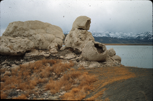
Slide of the rock formation known as The Squaw and Her Basket, Pyramid Lake, Nevada, circa 1970s
Date
1970 to 1979
Archival Collection
Description
The rock formation known as The Squaw and Her Basket, Pyramid Lake, Nevada. Pyramid Lake is the geographic sink of the Truckee River Basin, 40 mi (64 km) northeast of Reno. Pyramid Lake is fed by the Truckee River, which is mostly the outflow from Lake Tahoe. The Truckee River enters Pyramid Lake at its southern end. Pyramid Lake has no outlet, with water leaving only by evaporation, or sub-surface seepage (an endorheic lake). The lake has about 10% of the area of the Great Salt Lake, but it has about 25% more volume. The salinity is approximately 1/6 that of sea water. Although clear Lake Tahoe forms the headwaters that drain to Pyramid Lake, the Truckee River delivers more turbid waters to Pyramid Lake after traversing the steep Sierra terrain and collecting moderately high silt-loaded surface runoff. Pyramid Lake is the site of some of the Earth's most spectacular tufa deposits. Tufa is a rock composed of calcium carbonate (CaCO3) that forms at the mouth of a spring, from lake water, or from a mixture of spring and lake water. The explorer John C. Fremont (1845) wrote about the tufas during his 1843-44 expedition and named the lake after the pyramidal-shaped island that lies along the east shore of the lake. The Paiute name for the island is Wono, meaning cone-shaped basket. The Paiute name for the lake is Cui-Ui Panunadu, meaning fish in standing water.
Image
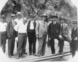
Film transparency of businessmen, politicians, and engineers at Hoover Dam, June 6, 1933
Date
1933-06-06
Archival Collection
Description
Black and white image of the group of men who witnessed the pouring of the first concrete in Hoover Dam proper. From left to right: H. J. Lawler, Director of Six Companies, Inc.; Walker R. Young, Construction Engineer, U.S. Bureau of Reclamation; Frank T. Crowe, General Superintendent, Six Companies, Inc.; C. A. Shea, Director of Construction, Six Companies, Inc. W. A. Bechtel, President, Six Companies, Inc.; R. F. Walter, Chief Engineer, U.S. Bureau of Reclamation; Theodore A. Walters, First Assistant Secretary of the Interior ; Ed Clark & C. P. Squires, members of the original Colorado River Commission. Note: Boulder Dam was officially renamed Hoover Dam in 1947.
Image
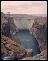
Film transparency of the south face Glen Canyon Dam, Arizona, circa 1966-1970s
Date
1966 to 1979
Archival Collection
Description
Glen Canyon Dam is a concrete arch dam on the Colorado River in northern Arizona in the United States, near the town of Page. Its reservoir is called Lake Powell, and is the second-largest artificial lake in the country, extending upriver well into Utah. The dam is named for Glen Canyon, a colorful series of gorges, most of which now lies under the reservoir. The dam was proposed in the 1950s as part of the Colorado River Storage Project, a U.S. Bureau of Reclamation (USBR) federal water project that would develop reservoir storage on the upper Colorado River and several of its major tributaries. Construction of Glen Canyon Dam started in 1956 and was not finished until 1966. The Glen Canyon Bridge or Glen Canyon Dam Bridge is a steel arch bridge in Coconino County, Arizona, carrying U.S. Route 89 across the Colorado River. The bridge was originally built by the United States Bureau of Reclamation to facilitate transportation of materials for the Glen Canyon Dam, which lies adjacent to the bridge just 865 feet (264 m) upstream. Carrying two lanes, the bridge rises over 700 feet (210 m) above the river and was the highest arch bridge in the world at the time of its completion in 1959.
Image
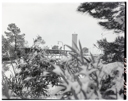
Film transparency of the Flamingo Hotel and Casino, Las Vegas, Nevada, January 7, 1955
Date
1955-01-07
Archival Collection
Description
The Flamingo Hotel and Casino in Las Vegas, Nevada, as seen through a snow-laden bush. The Marquee is visible in the background, advertising Tony Martin, The Goofers, The interludes, Ron Fletcher, Salmas Brothers, Bobby Page, and others. Benjamin "Busgsy" Siegel, opened The Flamingo Hotel & Casino at a total cost of $6 million on December 26, 1946 to poor reception and soon closed. It reopened in March 1947 with a finished hotel. Three months later, on June 20, 1947, Siegel was shot dead at the Beverly Hills home of his girlfriend, Virginia Hill. Billed as "The West's Greatest Resort Hotel," the 105-room property and first luxury hotel on the Strip, was built 4 miles (6.4 km) from Downtown Las Vegas, with a large sign built in front of the construction site announcing it was a William R. Wilkerson project, with Del Webb Construction as the prime contractor and Richard R. Stadelman (who later made renovations to the El Rancho Vegas) the architect. Lore has it that Siegel named the resort after his girlfriend Virginia Hill, who loved to gamble and whose nickname was "Flamingo," a nickname Siegel gave her due to her long, skinny legs. Organized crime king Lucky Luciano wrote in his memoir that Siegel once owned an interest in the Hialeah Park Race Track and viewed the flamingos who populated nearby as a good omen. In fact, the "Flamingo" name was given to the project at its inception by Wilkerson.
Image
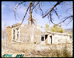
Film transparency of the Old Buck Station, Newark Valley, Nevada, 1955
Date
1955
Archival Collection
Description
The Old Buck Station, where the Hill-Beachy freight line stopped to trade horses. To get to Buck Station from Illipah, head west on U.S. 50 for 20.2 miles. Exit right onto the old Elko-Hamilton Stage road (very poor, heavily rutted) and follow for 11 miles. Bear left at fork and continue for 9 miles to Buck Station. Buck Station was an important stop on the Elko-Hamilton stage line. The station was the scene of bustling activity during the late 1860s as travelers rushed from northern Nevada to Hamilton. The Hill-Beachy freight line used Buck Station as a place to switch horses. All was not safe and secure at Buck Station, however. In May 1869, the Wells-Fargo stage was held up. $40,000 was taken, and four men were killed. The money was never recovered, and legend has it that the treasure is buried somewhere near the station. When the robbers were caught, only a few miles away, they had already hidden the money. Once Hamilton began to decline in 1870, Buck Station lost its importance, and by the late 1870s the station was no longer used. In the 1880s, a small and very successful ranch began operations, continuing in business until the 1930s. Today there are extensive and fascinating remains at Buck Station.
Image
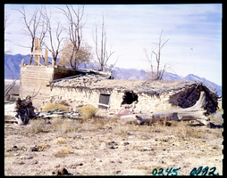
Film transparency of the Old Buck Station, Newark Valley, Nevada, 1955
Date
1955
Archival Collection
Description
The Old Buck Station, where the Hill-Beachy freight line stopped to trade horses. To get to Buck Station from Illipah, head west on U.S. 50 for 20.2 miles. Exit right onto the old Elko-Hamilton Stage road (very poor, heavily rutted) and follow for 11 miles. Bear left at fork and continue for 9 miles to Buck Station. Buck Station was an important stop on the Elko-Hamilton stage line. The station was the scene of bustling activity during the late 1860s as travelers rushed from northern Nevada to Hamilton. The Hill-Beachy freight line used Buck Station as a place to switch horses. All was not safe and secure at Buck Station, however. In May 1869, the Wells-Fargo stage was held up. $40,000 was taken, and four men were killed. The money was never recovered, and legend has it that the treasure is buried somewhere near the station. When the robbers were caught, only a few miles away, they had already hidden the money. Once Hamilton began to decline in 1870, Buck Station lost its importance, and by the late 1870s the station was no longer used. In the 1880s, a small and very successful ranch began operations, continuing in business until the 1930s. Today there are extensive and fascinating remains at Buck Station.
Image
Pagination
Refine my results
Content Type
Creator or Contributor
Subject
Archival Collection
Digital Project
Resource Type
Year
Material Type
Place
Language
Records Classification
