Search Results
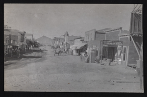
Looking north on Main Street, Goldfield, Nevada: photographic print
Date
1905
Archival Collection
Description
From the Frank Benham Photograph Collection on Goldfield, Nevada (PH-00288). Written on the back of image: "Main St., Goldfield, Nevada, 1905. Early days-looking north." (photo by F.HBenham).
Image
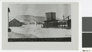
Photograph of winter landscape in Goodsprings, Nevada, 1928
Date
1928
Archival Collection
Description
Buildings and water tank in Goodsprings, Nevada.
Image
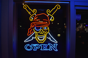
Pirate window sign, Reno, Nevada
Date
2016 (year approximate) to 2020 (year approximate)
Archival Collection
Description
View of a pirate sign in an unknown locaiton
Image
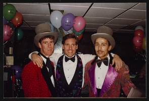
People at Angles Nightclub in Las Vegas, Nevada: photographic prints, image 019
Description
Handwritten on a Post-It note on verso: "New Year's Eve 1994".
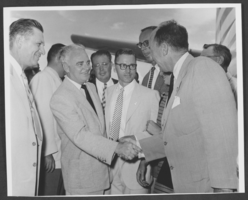
Photograph of Wilbur Clark shaking hands with Adlai Stevenson, Las Vegas, Nevada, circa 1950s
Date
1950 to 1959
Archival Collection
Description
Wilbur Clark shakes hands with Adlai Stevenson (right) near an airplane, Las Vegas, Nevada, circa 1950s. the photo taken by Mark Swain ,Desert Inn.
Image

Aid for AIDS of Nevada Black and White Party flyer
Date
2009-08-22
Archival Collection
Description
From the Dennis McBride Collection on LGBTQ Las Vegas, Nevada (MS-00802) -- Alphabetical research files -- AIDS: Black and White Party file.
Text
University of Nevada, Las Vegas (UNLV) 27th commencement program
Date
1990-05-13
Archival Collection
Description
Commencement program from University of Nevada, Las Vegas Commencement Programs and Graduation Lists (UA-00115).
Text
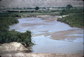
Slide of Virgin River, Nevada, circa 1960s
Date
1960 to 1969
Archival Collection
Description
Virgin River at Bunkerville Dam in Nevada.
Image
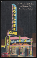
The Boulder Club in Las Vegas, Nevada: postcard
Date
1940 (year approximate) to 1990 (year approximate)
Archival Collection
Description
From the Harvey's Hotel and Casino Postcard Collection (PH-00367) -- An artistic rendition of the Boulder Club sign and marquee located in Las Vegas, Nevada. The address for the club is included on the postcard, "The Boulder Club, Inc., 118 Fremont St., Las Vegas, Nevada"
Image
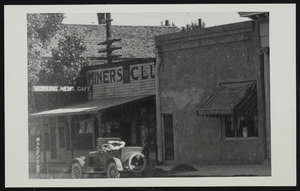
Miners Club in Las Vegas, Nevada: photographic print
Date
1920 (year approximate) to 1929 (year approximate)
Archival Collection
Description
From the UNLV Libraries Single Item Accession Photograph Collection (PH-00171). Working Men's Cafe
Image