Search Results
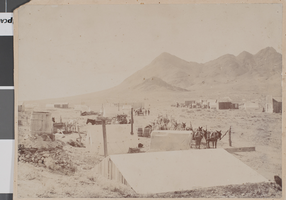
Photograph of Camp Butler, Tonopah, Nevada, January 1901
Date
1901-01
Archival Collection
Description
A small mining camp established by Jim Butler near the mountains in Tonopah, Nevada.
Image

William Kissam Vanderbilt, Nevada assemblyman: photographic print
Date
1980
Archival Collection
Description
William Kissam Vanderbilt, former state assembleyman from Las Vegas, Nevada
Image
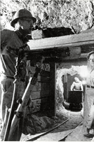
Mining operation in the vicinity of Beatty, Nevada: photographic print
Date
1956-05
Archival Collection
Description
From the Nye County, Nevada Photograph Collection (PH-00221) -- Series III. Beatty, Nevada -- Subseries III.C. Revert Family. Photograph appeared in conjunction with an article on the Revert brothers in Minute Man Magazine.
Image
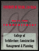
University of Nevada, Las Vegas (UNLV) College of Architecture, Construction Management and Planning 33rd commencement program
Date
1996-05-11
Archival Collection
Description
Commencement program from University of Nevada, Las Vegas Commencement Programs and Graduation Lists (UA-00115).
Text
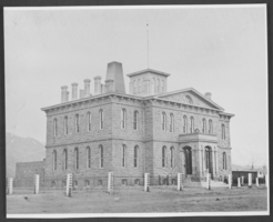
Photograph of Carson City Mint, Nevada, circa 1866
Date
1865 to 1867
Archival Collection
Description
An exterior view of the Carson City Mint, which officially began operations on January 8, 1870 in Carson City, Nevada. It later became the Nevada State Museum, which officially opened on October 31, 1941.
Image
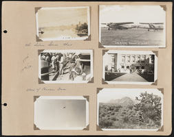
Southern Nevada Photo Album, image 118
Description
118.1 Blurry picture identified as the Colorado River. ; 118.2 Postcard picture showing two airplanes, identified as Las Vegas, Nevada airport. ; 118.3 The silver spike that started work on Hoover Dam. September 17, 1930. ; 118.4 Courthouse for speeches; 9/17/30; 118.5 N.A.E. Transport over Boulder 9-17-30 ; 118.6 Postcard picture showing a mountain scene.
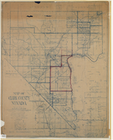
Map of Clark County, Nevada, 1927
Date
1927
Description
'Compiled by J.T. McWilliams from official county records, U.S. Land Dept. surveys, railroad co. field maps and many personal surveys. Made in 1927 by J.T. McWilliams, C.E.' Includes township and road districts, school districts, mining districts, railroads, wagon roads, trails, springs and artesian wells. Scale [ca. 1:316,800. 1 in. to approx. 5 miles] (W 116°--W 114°/N37--N35). Relief shown by hachures. Blueline print. Library's copy 1 has one area outlined by hand in red. Library's copy 2 has school districts outlined in red and green pencil and labeled in pencil by hand.
Image

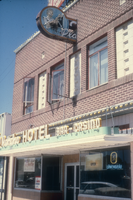
Slide of El Rancho Hotel, Wells, Nevada, 1986
Date
1986
Archival Collection
Description
An image of the exterior of the El Rancho Hotel located in Wells, Nevada. The neon sign near the top of the photo depicts an animated man with a slot machine, while the neon yellow sign located just above the entrance door reads: "El Rancho Hotel, Bar - Casino." Site Name: El Rancho Hotel (Wells, Nev.)
Image