
Search the Special Collections and Archives Portal

Search Results

Display    Results Per Page
Displaying results 7091 - 7100 of 559108

Plat of H.F.M & M addition to city of Las Vegas, Clark County, Nevada, comprising the west 1/2 of N.W. 1/4 Sec. 27, Twp. 20 S., R. 61 E., M.D.B & M, March 8, 1924

Date

1924-03-08

Description

Blue-line print ; 74 x 36 cm on sheet 79 x 61 cm. Survey was competed on March 8, 1924. Signed by the owners of the piece of property for the addition Roy W. Martin, Forest R. Mildren, William E. Ferron, and A. W. Ham, signed by the surveyor J.T. McWilliams, and notarized on March 31, 1924. Approved by the Board of City Commissioners and signed by the major W. C. German and by Florence S. Doherty, city clerk, on April 1, 1924. Recorded in Book 1 of plats, page 47. Includes township and range grid.

Image

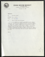
Nevada Southern University law program: reports and correspondence

Date

1966 to 1968

Description

Folder contains memorandums, correspondence related to the law program at Nevada Southern University (later UNLV). It includes a report on the NSU law program (fall term 1967-1968), a report of the Association of American Law Schools Committee on Guidelines for New Law Schools (1966), and a report of Dean Willard H. Pedrick, Arizona State University College of Law (1967). From the University of Nevada, Las Vegas William S. Boyd School of Law Records (UA-00048).

Text

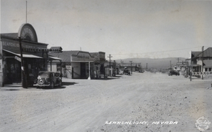
Postcard showing Searchlight, Nevada, circa 1930s

Date

1930 to 1939

Archival Collection

Description

The view of a street passing through Searchlight, Nevada. Formed in 1897, Searchlight is an old boomtown that was made popular when George Frederick Colton discovered gold at the location where the town is now built. Different shops and automobiles line the sides of the dirt road, while mountains and shrubs lie in the distance. Stores that reside on the left side of the street include The Big Store grocery and supply store, Arrowhead Garage, and a cafe. Buildings such as a garage and the Nevada Hotel stand on the opposing right side of the street. Transcribed onto the bottom of the postcard: "Searchlight, Nevada." The Frasher's Foto logo is also printed onto the bottom right corner.

Image

Nevada Women's Archives Records

Identifier

UA-00052

Abstract

Records (1994-1999) are comprised of planning documents, newspaper clippings, external communication, and memoranda documenting the establishment and operations of the Nevada Women's Archives at the University of Nevada, Las Vegas. The records primarily document collection materials from the first exhibit created using the Nevada Women's Archive.

Archival Collection

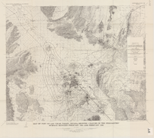
Map of part of Las Vegas Valley, Nevada, showing changes in the piezometric surface between February 1955 and February 1956

Date

1965

Description

Relief shown by contours. Includes township and range lines. Scale 1:96,000 (W 115°30´--W 114°45´/N 36°30´--N 36°00´). Series: Water-supply paper (Washington, D.C.)1780. Originally published as plate 5 of Available water supply of the Las Vegas ground-water basin, Nevada, by Glenn T. Malmberg, published by the Geological Survey in 1965 as its Water-supply paper 1780.

Image

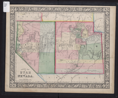
County map of Utah and Nevada, 1865

Date

1865

Description

'Entered according to Act of Congress in the year 1865 by S. Augustus Mitchell, Jr. in the Clerk's office of the District Court of the U.S. for the Eastern District of Pennsylvania . Drawn and engraved by W.H. Gamble, Philadelphia.' Shows roads, overland telegraph route, and other features. Relief shown by hachures and spot heights. Prime meridians: Greenwich and Washington. Scale [ca. 1:2,787,840] (W 120°--W 109°/N 43°--N 36° 59?).

Image

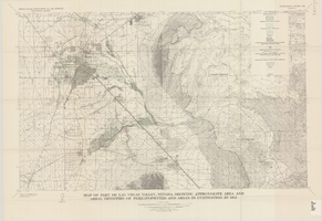
Map of part of Las Vegas Valley, Nevada, showing approximate area and areal densities of phreatophytes and areas in cultivation in 1912

Date

1965

Description

Genre/Form: Thematic maps. Scale 1:62,500 (W 115°15´--W 114°45´/N 36°15´--N 36°00´). 1 map : col. ; 45 x 72 cm. Series: Water-supply paper (Washington, D.C.) ; 1780. Relief shown by contours. Originally published as plate 11 of Available water supply of the Las Vegas ground-water basin, Nevada, by Glenn T. Malmberg, published by the Geological Survey in 1965 as its Water-supply paper 1780. Includes township and range lines. Interior, Geological Survey

Image

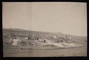
Mines at Milltown, Nevada: photographic print

Date

1905

Description

From the Frank Benham Photograph Collection on Goldfield, Nevada (PH-00288).

Image

Map of Lincoln County, Nevada and Mohave County, Arizona area, 1892

Date

1892

Description

'Henry Gannett, chief geographer ; A.H. Thompson, geographer in charge ; triangulation by H.M. Wilson ; topography by H.M. Wilson and Powell survey.' 'Edition of Mar. 1892, reprinted 1929.' Handwritten legend on right-side margin of map. Original publisher: Dept. of the Interior, U.S. Geological Survey. Scale 1:250,000polyconic proj. (W 115°--W 114°/N 37°--N 35°).

Image