Search Results

Photograph of Nevada governors, Nevada, 1973
Date
1973
Archival Collection
Description
Nevada Governors from left to right: Charles Russell (seated), Mike O'Callaghan, Paul Laxalt and Grant Sawyer. Note provided on back of photo: "'I received appointments from each to Retirement Board -- and from Laxalt, O' Callaghan and List (not shown) to the State Historical Society Board of Trustees.' -- Elbert Edwards."
Image
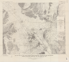
Map of part of Las Vegas Valley, Nevada, showing changes in the piezometric surface between February 1955 and February 1956
Date
1965
Description
Relief shown by contours. Includes township and range lines. Scale 1:96,000 (W 115°30´--W 114°45´/N 36°30´--N 36°00´). Series: Water-supply paper (Washington, D.C.)
1780. Originally published as plate 5 of Available water supply of the Las Vegas ground-water basin, Nevada, by Glenn T. Malmberg, published by the Geological Survey in 1965 as its Water-supply paper 1780.
1780. Originally published as plate 5 of Available water supply of the Las Vegas ground-water basin, Nevada, by Glenn T. Malmberg, published by the Geological Survey in 1965 as its Water-supply paper 1780.
Image
Nevada Women's Archives Records
Identifier
UA-00052
Abstract
Records (1994-1999) are comprised of planning documents, newspaper clippings, external communication, and memoranda documenting the establishment and operations of the Nevada Women's Archives at the University of Nevada, Las Vegas. The records primarily document collection materials from the first exhibit created using the Nevada Women's Archive.
Archival Collection
Hazel Denton's daughter posed in front of bench with a house in the background. Written on the image: "Betty making mud pies on the washing board. Note the curl right in the middle of her forehead": photographic print, approximately 1900-1965
Level of Description
Item
Archival Collection
Hazel Baker Denton Photograph Collection
To request this item in person:
Collection Number: PH-00312
Collection Name: Hazel Baker Denton Photograph Collection
Box/Folder: Folder 02
Collection Name: Hazel Baker Denton Photograph Collection
Box/Folder: Folder 02
Archival Component
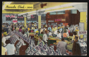
The Nevada Club in Reno, Nevada: postcard, image 001
Description
The Nevada Club in Reno, Nevada.
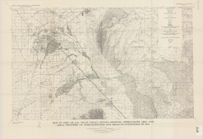
Map of part of Las Vegas Valley, Nevada, showing approximate area and areal densities of phreatophytes and areas in cultivation in 1912
Date
1965
Description
Genre/Form: Thematic maps. Scale 1:62,500 (W 115°15´--W 114°45´/N 36°15´--N 36°00´). 1 map : col. ; 45 x 72 cm. Series: Water-supply paper (Washington, D.C.) ; 1780. Relief shown by contours. Originally published as plate 11 of Available water supply of the Las Vegas ground-water basin, Nevada, by Glenn T. Malmberg, published by the Geological Survey in 1965 as its Water-supply paper 1780. Includes township and range lines. Interior, Geological Survey
Image
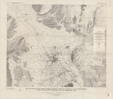
Map of part of Las Vegas Valley, Nevada, showing changes in the piezometric surface between February 1944 and February 1956
Date
1965
Description
Scale 1:62,500 (W 115°15´--W 114°45´/N 36°30´--N 36°00´). 1 map : col. ; 58 x 70 cm. Series: Water-supply paper (Washington, D.C.) ; 1780. Relief shown by contours. Originally published as plate 6 of Available water supply of the Las Vegas ground-water basin, Nevada, by Glenn T. Malmberg, published by the Geological Survey in 1965 as its Water-supply paper 1780. Includes township and range lines. Interior, Geological Survey
Image

Hydrogeologic map of Nevada Test Site and vicinity, southern Nevada, 1965
Date
1965
Description
At top of map: ' United States Department of the Interior, Geological Survey. Professional paper 712-C, plate 1. Prepared on behald of the U.S. Atomic Energy Commission.' At bottom of map: 'Base from U.S. Geological Survey, Caliente, Death Valley, Goldfield and Las Vegas, 1954. 100,00-foot grid based on Nevada coordinate system, central zone.' 'Hydrogeology by I. J. Winograd, 1965; geology by William Thordarson.' Relief shown by contours and spot heights. Shows township and range lines. Includes diagram of downward and upward cross-flow of water. Includes bibliographical references and index. Contour interval 200 feet. Scale 1:250,000 (W 117°--W 115°/N 38°--N 36°). Series: Professional paper (Geological Survey (U.S.), 712-C. Issued as plate 1 from Hydrogeologic and hydrochemical framework, south-central Great Basin, Nevada-California with special reference to the Nevada Test Site. Prepared on behalf of the U.S. Atomic Energy Commission by Isaac J. Winograd and William Thordarson. Published 1975 by U.S. Govt. Print. Off. in Washington.
Image
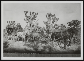
Stagecoach in Nevada, image 001: photographic print
Date
1900 (year uncertain) to 1939 (year uncertain)
Archival Collection
Description
Unidentified individuals on a stagecoach ride through Nevada.
Image