
Search the Special Collections and Archives Portal

Search Results

Display    Results Per Page
Displaying results 211 - 220 of 576778

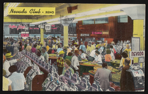
Club Cal Nevada in Reno, Nevada: postcard

Date

1940 (year approximate) to 1990 (year approximate)

Description

From the Harvey's Hotel and Casino Postcard Collection (PH-00367) -- Club Cal Nevada in Reno, Nevada at night

Image

Main Street, Goldfield, Nevada, postcard

Description

Postcard of Main Street, Goldfield, Nevada.

Hotel Nevada Guest Register

Identifier

MS-00634

Abstract

The Hotel Nevada Guest Register (1910-1911) consists of one register from the Hotel Nevada, which opened on the southeast corner of Main Street and Fremont Street in Las Vegas, Nevada in 1906. This particular volume lists guest names and their home citieslocated on the corner of Fremont and Main Streets.

Archival Collection

Nevada State Highway Commission Reports

Identifier

MS-00703

Abstract

The Nevada State Highway Commission Reports (1917-1972) contain biennial reports regarding completed and planned projects of the Nevada Department of Highways.

Archival Collection

Hydrogeologic map of Nevada Test Site and vicinity, southern Nevada, 1965

Date

1965

Description

At top of map: ' United States Department of the Interior, Geological Survey. Professional paper 712-C, plate 1. Prepared on behald of the U.S. Atomic Energy Commission.' At bottom of map: 'Base from U.S. Geological Survey, Caliente, Death Valley, Goldfield and Las Vegas, 1954. 100,00-foot grid based on Nevada coordinate system, central zone.' 'Hydrogeology by I. J. Winograd, 1965; geology by William Thordarson.' Relief shown by contours and spot heights. Shows township and range lines. Includes diagram of downward and upward cross-flow of water. Includes bibliographical references and index. Contour interval 200 feet. Scale 1:250,000 (W 117°--W 115°/N 38°--N 36°). Series: Professional paper (Geological Survey (U.S.), 712-C. Issued as plate 1 from Hydrogeologic and hydrochemical framework, south-central Great Basin, Nevada-California with special reference to the Nevada Test Site. Prepared on behalf of the U.S. Atomic Energy Commission by Isaac J. Winograd and William Thordarson. Published 1975 by U.S. Govt. Print. Off. in Washington.

Image

Nevada Resort Association Records

Identifier

MS-00815

Abstract

The records are comprised of subject files and reports from approximately the 1990s to the 2000s related to data gathering and lobbying activities of the Nevada Resort Association. Materials include drafts of legislation related to gaming, tax reports, health and safety regulations, labor and employment matters, and zoning issues.

Archival Collection

Photograph of Nevada governors, Nevada, 1973

Date

1973

Description

Nevada Governors from left to right: Charles Russell (seated), Mike O'Callaghan, Paul Laxalt and Grant Sawyer. Note provided on back of photo: "'I received appointments from each to Retirement Board -- and from Laxalt, O' Callaghan and List (not shown) to the State Historical Society Board of Trustees.' -- Elbert Edwards."

Image

Map showing configuration of potentiometric surfaces in Paleozoic and Cenozoic aquifers in the area between the Las Vegas Valley and the Amargosa Desert, Nevada, 1963

Date

1963

Description

'Department of the Interior, United States Geological Survey. TEI-840.' 'Prepared in cooperation with the U.S. Atomic Energy Commission.' 'Contours in northwest Las Vegas Valley from Malmberg, 1961.' Relief shown by contours. Shows township and range lines. Scale [ca. 1:253,440. 1 in.=aprrox. 4 miles] (W 114°00´--W 115°00´--N 37°00´/N 36°00´). Originally published in A summary of the ground-water hydrology of the area between the Las Vegas Valley and the Amargosa Desert, Nevada : with special reference to the effects of possible new withdrawals of ground water / by Isaac J. Winograd, published by the U.S. Geological Survey in 1963 as number 840 of the Trace elements investigations report.

Image

Map of Lincoln County, Nevada and Mohave County, Arizona area, 1892

Date

1892

Description

'Henry Gannett, chief geographer ; A.H. Thompson, geographer in charge ; triangulation by H.M. Wilson ; topography by H.M. Wilson and Powell survey.' 'Edition of Mar. 1892, reprinted 1929.' Handwritten legend on right-side margin of map. Original publisher: Dept. of the Interior, U.S. Geological Survey. Scale 1:250,000
polyconic proj. (W 115°--W 114°/N 37°--N 35°).

Image

The Nevada Club in Reno, Nevada: postcard, image 001

Description

The Nevada Club in Reno, Nevada.