Search the Special Collections and Archives Portal
Search Results
Alpha Kappa Alpha Sorority, Theta Theta Omega Chapter "Hodegos" reports
Date
1997
Archival Collection
Description
From the Alpha Kappa Alpha Sorority, Incorporated, Theta Theta Omega Chapter Records (MS-01014) -- Chapter records file.
Text
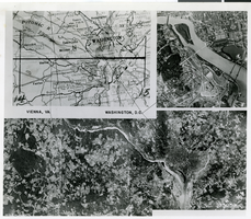
Aerial photograph of Potomac area, with map, demonstrating the Lockheed Shooting Star mapping plane, October 28, 1946
Date
1946-10-28
Archival Collection
Description
An aerial photograph with a city map in the upper left corner. Transcribed description from back of the photograph: "AAF' 'Shooting Star' does mapping at 475 mph. An Army Air Forces XFP-80, the 'Shooting Star' built by Lockheed recently made a 51 minute run from Wright Field, Dayton, Ohio, to Washington, D.C., photographing 16,000 square miles of territory along the route for mapping purposes. The flight established a new record in photographic mapping, covering 314 square miles per minute. A new tri-metrogen K-17-B aerial camera installation, consisting of three cameras positioned and times to record the terrain from horizon to horizon was used. The test flight proved the new jet type aircraft perfect for any Air Forces mapping job. Jets, due to the lack of vibration, allow perfect exposure in minute detail without the use of intricate stabilized camera mounts."
Image
Pagination
Refine my results
Content Type
Creator or Contributor
Subject
Archival Collection
Digital Project
Resource Type
Year
Material Type
Place
Language
Records Classification

