Search Results
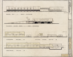
Architectural drawing of Sahara Hotel Convention Center (Las Vegas), elevations and sections, August 15, 1967
Date
Archival Collection
Description
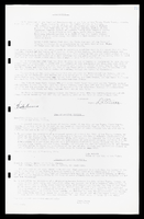
Architectural plans for the Sahara Hotel Convention Center from 1967. Includes revisions. Printed on mylar. Berton Charles Severson, architect; Brian Walter Webb, architect; Masyoshi Tokubo, delineator.
Site Name: Sahara Hotel and Casino
Address: 2535 Las Vegas Boulevard South
Image
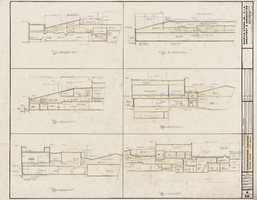
Architectural drawing of Sahara Hotel Convention Center (Las Vegas), casino sections, August 15, 1967
Date
Archival Collection
Description
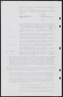
Cross sections of the Sahara Hotel Convention Center from 1967. Includes revisions. Printed on mylar. Berton Charles Severson, architect; Brian Walter Webb, architect; Fred D. Anderson, delineator.
Site Name: Sahara Hotel and Casino
Address: 2535 Las Vegas Boulevard South
Image
Nevada Burial Records of Stewart Ranch
Identifier
Abstract
The Nevada Burial Records of Stewart Ranch date from 1905 to 1913 and consist of a ledger recording those buried at Stewart Ranch in Las Vegas, Nevada. The entries in the ledger document the names of the deceased and where they died. Some entries have additional information explaining how the person died and their height and weight.
Archival Collection
Rhodes, Susan
Susan Rhodes was a member of Temple Beth Am in 2006-2007 when the congregation merged with Adat Ariel to form Temple Sinai. During 2006 Rhodes served as Sergeant-at-arms during Temple Beth AM at meetings that were held to discuss the financial issues faced by Temple Beth Am and as secretary during the 2007 merger.
Person
Kleinman, Morris
Morris Kleinman was a part-owner of the Desert Inn hotel and casino in Las Vegas, Nevada, along with his business partners Moe Dalitz and Ruby Kolod. Before Kleinman and Dalitz relocated in Vegas in 1949, they were members of the Mayfield Road Gang in Cleveland, Ohio.
Schwartz, David G. Roll the Bones: The History of Gambling. Casino Edition. Las Vegas: Winchester Books, 2013.
Person
