Search the Special Collections and Archives Portal
Search Results
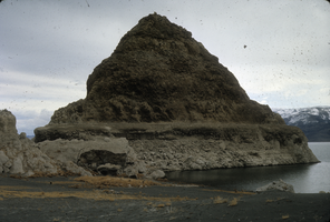
Slide of a tufa deposit in Pyramid Lake, Nevada, circa 1970s
Date
1970 to 1979
Archival Collection
Description
The pyramid-shaped island tufa that lies along the east shore of the lake and is the reason the lake was named Pyramid Lake. Pyramid Lake is the geographic sink of the Truckee River Basin, 40 mi (64 km) northeast of Reno. Pyramid Lake is fed by the Truckee River, which is mostly the outflow from Lake Tahoe. The Truckee River enters Pyramid Lake at its southern end. Pyramid Lake has no outlet, with water leaving only by evaporation, or sub-surface seepage (an endorheic lake). The lake has about 10% of the area of the Great Salt Lake, but it has about 25% more volume. The salinity is approximately 1/6 that of sea water. Although clear Lake Tahoe forms the headwaters that drain to Pyramid Lake, the Truckee River delivers more turbid waters to Pyramid Lake after traversing the steep Sierra terrain and collecting moderately high silt-loaded surface runoff. Pyramid Lake is the site of some of the Earth's most spectacular tufa deposits. Tufa is a rock composed of calcium carbonate (CaCO3) that forms at the mouth of a spring, from lake water, or from a mixture of spring and lake water. The explorer John C. Fremont (1845) wrote about the tufas during his 1843-44 expedition and named the lake after the pyramidal-shaped island that lies along the east shore of the lake. The Paiute name for the island is Wono, meaning cone-shaped basket. The Paiute name for the lake is Cui-Ui Panunadu, meaning fish in standing water.
Image
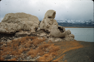
Slide of the rock formation known as The Squaw and Her Basket, Pyramid Lake, Nevada, circa 1970s
Date
1970 to 1979
Archival Collection
Description
The rock formation known as The Squaw and Her Basket, Pyramid Lake, Nevada. Pyramid Lake is the geographic sink of the Truckee River Basin, 40 mi (64 km) northeast of Reno. Pyramid Lake is fed by the Truckee River, which is mostly the outflow from Lake Tahoe. The Truckee River enters Pyramid Lake at its southern end. Pyramid Lake has no outlet, with water leaving only by evaporation, or sub-surface seepage (an endorheic lake). The lake has about 10% of the area of the Great Salt Lake, but it has about 25% more volume. The salinity is approximately 1/6 that of sea water. Although clear Lake Tahoe forms the headwaters that drain to Pyramid Lake, the Truckee River delivers more turbid waters to Pyramid Lake after traversing the steep Sierra terrain and collecting moderately high silt-loaded surface runoff. Pyramid Lake is the site of some of the Earth's most spectacular tufa deposits. Tufa is a rock composed of calcium carbonate (CaCO3) that forms at the mouth of a spring, from lake water, or from a mixture of spring and lake water. The explorer John C. Fremont (1845) wrote about the tufas during his 1843-44 expedition and named the lake after the pyramidal-shaped island that lies along the east shore of the lake. The Paiute name for the island is Wono, meaning cone-shaped basket. The Paiute name for the lake is Cui-Ui Panunadu, meaning fish in standing water.
Image
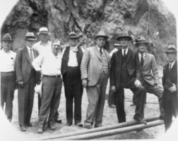
Film transparency of businessmen, politicians, and engineers at Hoover Dam, June 6, 1933
Date
1933-06-06
Archival Collection
Description
Black and white image of the group of men who witnessed the pouring of the first concrete in Hoover Dam proper. From left to right: H. J. Lawler, Director of Six Companies, Inc.; Walker R. Young, Construction Engineer, U.S. Bureau of Reclamation; Frank T. Crowe, General Superintendent, Six Companies, Inc.; C. A. Shea, Director of Construction, Six Companies, Inc. W. A. Bechtel, President, Six Companies, Inc.; R. F. Walter, Chief Engineer, U.S. Bureau of Reclamation; Theodore A. Walters, First Assistant Secretary of the Interior ; Ed Clark & C. P. Squires, members of the original Colorado River Commission. Note: Boulder Dam was officially renamed Hoover Dam in 1947.
Image
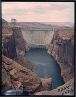
Film transparency of the south face Glen Canyon Dam, Arizona, circa 1966-1970s
Date
1966 to 1979
Archival Collection
Description
Glen Canyon Dam is a concrete arch dam on the Colorado River in northern Arizona in the United States, near the town of Page. Its reservoir is called Lake Powell, and is the second-largest artificial lake in the country, extending upriver well into Utah. The dam is named for Glen Canyon, a colorful series of gorges, most of which now lies under the reservoir. The dam was proposed in the 1950s as part of the Colorado River Storage Project, a U.S. Bureau of Reclamation (USBR) federal water project that would develop reservoir storage on the upper Colorado River and several of its major tributaries. Construction of Glen Canyon Dam started in 1956 and was not finished until 1966. The Glen Canyon Bridge or Glen Canyon Dam Bridge is a steel arch bridge in Coconino County, Arizona, carrying U.S. Route 89 across the Colorado River. The bridge was originally built by the United States Bureau of Reclamation to facilitate transportation of materials for the Glen Canyon Dam, which lies adjacent to the bridge just 865 feet (264 m) upstream. Carrying two lanes, the bridge rises over 700 feet (210 m) above the river and was the highest arch bridge in the world at the time of its completion in 1959.
Image
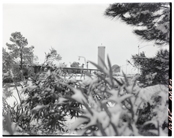
Film transparency of the Flamingo Hotel and Casino, Las Vegas, Nevada, January 7, 1955
Date
1955-01-07
Archival Collection
Description
The Flamingo Hotel and Casino in Las Vegas, Nevada, as seen through a snow-laden bush. The Marquee is visible in the background, advertising Tony Martin, The Goofers, The interludes, Ron Fletcher, Salmas Brothers, Bobby Page, and others. Benjamin "Busgsy" Siegel, opened The Flamingo Hotel & Casino at a total cost of $6 million on December 26, 1946 to poor reception and soon closed. It reopened in March 1947 with a finished hotel. Three months later, on June 20, 1947, Siegel was shot dead at the Beverly Hills home of his girlfriend, Virginia Hill. Billed as "The West's Greatest Resort Hotel," the 105-room property and first luxury hotel on the Strip, was built 4 miles (6.4 km) from Downtown Las Vegas, with a large sign built in front of the construction site announcing it was a William R. Wilkerson project, with Del Webb Construction as the prime contractor and Richard R. Stadelman (who later made renovations to the El Rancho Vegas) the architect. Lore has it that Siegel named the resort after his girlfriend Virginia Hill, who loved to gamble and whose nickname was "Flamingo," a nickname Siegel gave her due to her long, skinny legs. Organized crime king Lucky Luciano wrote in his memoir that Siegel once owned an interest in the Hialeah Park Race Track and viewed the flamingos who populated nearby as a good omen. In fact, the "Flamingo" name was given to the project at its inception by Wilkerson.
Image
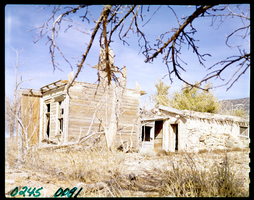
Film transparency of the Old Buck Station, Newark Valley, Nevada, 1955
Date
1955
Archival Collection
Description
The Old Buck Station, where the Hill-Beachy freight line stopped to trade horses. To get to Buck Station from Illipah, head west on U.S. 50 for 20.2 miles. Exit right onto the old Elko-Hamilton Stage road (very poor, heavily rutted) and follow for 11 miles. Bear left at fork and continue for 9 miles to Buck Station. Buck Station was an important stop on the Elko-Hamilton stage line. The station was the scene of bustling activity during the late 1860s as travelers rushed from northern Nevada to Hamilton. The Hill-Beachy freight line used Buck Station as a place to switch horses. All was not safe and secure at Buck Station, however. In May 1869, the Wells-Fargo stage was held up. $40,000 was taken, and four men were killed. The money was never recovered, and legend has it that the treasure is buried somewhere near the station. When the robbers were caught, only a few miles away, they had already hidden the money. Once Hamilton began to decline in 1870, Buck Station lost its importance, and by the late 1870s the station was no longer used. In the 1880s, a small and very successful ranch began operations, continuing in business until the 1930s. Today there are extensive and fascinating remains at Buck Station.
Image
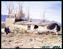
Film transparency of the Old Buck Station, Newark Valley, Nevada, 1955
Date
1955
Archival Collection
Description
The Old Buck Station, where the Hill-Beachy freight line stopped to trade horses. To get to Buck Station from Illipah, head west on U.S. 50 for 20.2 miles. Exit right onto the old Elko-Hamilton Stage road (very poor, heavily rutted) and follow for 11 miles. Bear left at fork and continue for 9 miles to Buck Station. Buck Station was an important stop on the Elko-Hamilton stage line. The station was the scene of bustling activity during the late 1860s as travelers rushed from northern Nevada to Hamilton. The Hill-Beachy freight line used Buck Station as a place to switch horses. All was not safe and secure at Buck Station, however. In May 1869, the Wells-Fargo stage was held up. $40,000 was taken, and four men were killed. The money was never recovered, and legend has it that the treasure is buried somewhere near the station. When the robbers were caught, only a few miles away, they had already hidden the money. Once Hamilton began to decline in 1870, Buck Station lost its importance, and by the late 1870s the station was no longer used. In the 1880s, a small and very successful ranch began operations, continuing in business until the 1930s. Today there are extensive and fascinating remains at Buck Station.
Image

Film transparency of the Tropicana Hotel's float entry in the Helldorado Parade, Fremont Street, Las Vegas, Nevada, May, 1957
Date
1957-05
Archival Collection
Description
The Tropicana Hotel's float entry in the Helldorado Parade, Fremont Street, May, 1957. The float's banner reads" 8th Wonder of the World, Tropicana Girls." There are five visible platforms on the float, with eight total platforms. "Sphinx", with two showgirls, "Parthenon", with one showgirl, "Tower of Pisa", with one showgirl, and "Hanging Garden", with one showgirl. The top platform has a showgirl riding in a giant flower. There are three platforms on the far side of the float that not visible. The first one is partially visible, with two pyramids visible. The name of the platform is not visible, and the showgirl is mostly obscured. The float has just padded Joe W. Brown's Horseshoe at the corner of Fremont Street and 2nd Street, and is passing the Boulder Club, located at 118 Fremont street. The Boulder Club was in operation from 1931-1960. A sign on the Boulder Club reads ""Farmer" Page - Enjoy the Old West - Jackpots, Craps, Bar, Keno, Roulette, Twenty-One." A smaller banner reads "J. K. Houssels - "Farmer" Page - Jim Young - Larry Hezzelwood." The Hotel Apache, and the Fremont Hotel are visible in the background.
Image
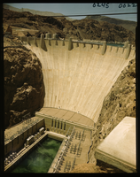
Film transparency of the face of Hoover (Boulder) Dam, taken from the downstream side of the dam on the Arizona side, May, 1947
Date
1947-05
Archival Collection
Description
The face of Hoover (Boulder) Dam, taken from the downstream side of the dam on the Arizona side, May, 1947. The intake towers are visible in the background. The hydroelectric generators are visible in the foreground. During the years of lobbying leading up to the passage of legislation authorizing the dam in 1928, Hoover Dam was originally referred to "Boulder Dam" or as "Boulder Canyon Dam", even though the proposed site had shifted to Black Canyon. The Boulder Canyon Project Act of 1928 (BCPA) never mentions a proposed name or title for the dam. When Secretary Wilbur spoke at the ceremony starting the building of the railway between Las Vegas and the dam site on September 17, 1930, he named the dam "Hoover Dam", citing a tradition of naming dams after Presidents, though none had been so honored during their terms of office. After Hoover's election defeat in 1932 and the accession of the Roosevelt administration, Secretary Ickes ordered on May 13, 1933 that the dam be referred to as "Boulder Dam". In the following years, the name "Boulder Dam" failed to fully take hold, with many Americans using both names interchangeably and map makers divided as to which name should be printed. In 1947, a bill passed both Houses of Congress unanimously restoring the name to "Hoover Dam".
Image
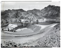
Film transparency of Hoover (Boulder) Dam, taken from the upstream side of the dam on the Arizona side, May, 1947
Date
1947-05
Archival Collection
Description
Hoover (Boulder) Dam, taken from the upstream side of the dam on the Arizona side, May, 1947. The intake towers, Nevada spillway house (in the background, behind the intake towers), and the Nevada spillway are visible. During the years of lobbying leading up to the passage of legislation authorizing the dam in 1928, Hoover Dam was originally referred to "Boulder Dam" or as "Boulder Canyon Dam", even though the proposed site had shifted to Black Canyon. The Boulder Canyon Project Act of 1928 (BCPA) never mentions a proposed name or title for the dam. When Secretary Wilbur spoke at the ceremony starting the building of the railway between Las Vegas and the dam site on September 17, 1930, he named the dam "Hoover Dam", citing a tradition of naming dams after Presidents, though none had been so honored during their terms of office. After Hoover's election defeat in 1932 and the accession of the Roosevelt administration, Secretary Ickes ordered on May 13, 1933 that the dam be referred to as "Boulder Dam". In the following years, the name "Boulder Dam" failed to fully take hold, with many Americans using both names interchangeably and map makers divided as to which name should be printed. In 1947, a bill passed both Houses of Congress unanimously restoring the name to "Hoover Dam".
Image
Pagination
Refine my results
Content Type
Creator or Contributor
Subject
Archival Collection
Digital Project
Resource Type
Year
Material Type
Place
Language
Records Classification
