
Search the Special Collections and Archives Portal

Search Results

Display    Results Per Page
Displaying results 58941 - 58950 of 144730

Association of Women in Science, Las Vegas Chapter Records

Identifier

MS-00740

Abstract

The Association of Women in Science, Las Vegas, Nevada Chapter Records date from 1976 to 1999 and cover DeLyle Eastwood's effort to create a local chapter of the Association of Women in Science (AWIS), the completion of this goal, and the proceedings of the Las Vegas AWIS chapter. The mission of the chapter was to help women in science career fields, both in the industry and university setting, achieve success in their fields. The AWIS also held seminars to spark early interest in science for young girls. The collection contains chapter correspondence, newsletters, and mentoring materials.

Archival Collection

Clark County, Nevada United States Bicentennial Collection

Identifier

MS-00183

Abstract

The Clark County, Nevada United States Bicentennial collection dates from approximately 1970 to 1976. The collection documents Nevada's participation in the 1976 Bicentennial celebration of the American Revolution, as well as celebrations from other states and countries in Europe. The collection is comprised of official reports from the U.S. Bicentennial committee, scrapbooks from the Clark County bicentennial committee, newspapers, and event programs from bicentennial celebrations around the country. The collection also contains a film of various American states' bicentennial celebrations.

Archival Collection

Washington University, School of Fine Arts Collection of Student Calendars

Identifier

MS-00996

Abstract

The Washington University, School of Fine Arts Collection of Calendars consists of thirty-three calendars created by students in the Washington University, School of Fine Arts created in 1983.

Archival Collection

UNLV Libraries Collection of Coast Casinos, Inc. Promotional and Publicity Materials

Identifier

MS-01008

Abstract

The UNLV Libraries Collection of Coast Casinos, Inc. Promotional and Publicity Materials includes press kits, press releases, promotional materials, and newspaper and magazine clippings for Coast Casinos, Inc. in Las Vegas, Nevada, dating from 1986 to 2009.

Archival Collection

John Janney Photograph Collection on Pioche, Nevada

Identifier

PH-00135

Abstract

The John Janney Photograph Collection on Pioche, Nevada contains photographs of mining operations and townspeople in Pioche, Nevada from 1908 to 1934. The photographs are primarily panoramic views of the town, mines, and landscape around Pioche, where Janney was president of Pioche Mines Consolidated until his death in 1967. The photographs also depict the baseball field in Pioche, a train crossing the desert in Lincoln County, and the Lee Family.

Archival Collection

Blueprint map showing proposed new 12" well and pipe line changes at water springs, Las Vegas, Nevada, circa 1920

Date

1916 to 1925

Description

Stamped : 'Approved (Signed) A. Maguire, Assistant Chief Engineer.' In lower right corner: '6-W-74.' Some annotations written over in yellow; black dotted line added between forebay and final spring in the northwest. Scale [ca. 1:6,000] 1 in.=500 feet

Image

Map showing profile of 24-inch cast iron water pipeline for Las Vegas, Nevada, May 20, 1930

Date

1930-05-20

Description

'As constructed. Drawing W.O. - 8577. Office of Chief Engineer, Los Angeles. Drawing No. 41092.' 'Scale for details 1"=10'. 5-20-1930. P.F.D.' 'Scale 1"=100'.' 'Profile of new 24" CI pipe. Scale 1"=600'. Ver. 1"=20'.' Blueprint. Map of the water pipes for Las Vegas. Includes the buildings in the railroad yard, a detailed map of a section of the pipe, a profile of the 24 inch C.I. pipe, and a map of the point of diversion. Date of detailed map is 5-20-1930. Library's copy has hand-written additions in color. Los Angeles & Salt Lake Railroad Co., Office of Chief Engineer,

Image

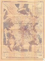
Map and basin profiles showing thickness of valley-fill deposits, Las Vegas Valley, Nevada, 1981

Date

1981

Description

At top of map: 'United States Department of the Interior. Geological Survey. Open-file report 84-130, plate 5.' 'Prepared in cooperation with the Clark County Department of Comprehensive Planning.' At bottom of map: 'Base from U.S. Geological Survey, 1:100,000, Boulder City, Ariz.-Nev., Las Vegas, Nev.-Calif., Mesquite Lake, Nev.-Calif., 1978; Lake Mead, Nev.-Ariz., 1979.' 'Geology from Malmberg (1965); Longwell and others (1965); Haynes (1967); Bell and Smith (1980); Bell (1981) and J. R. Harrill, 1976. Thickness of valley-fill deposits by R.W. Plume, 1981.' Includes three profiles. Shows township and range lines. Scale [ca. 1:95.040. 1 in.=approx. 1.5 miles] (W 115°30´--W 115°00´/N 36°30´--N 36°00´). Series: Open-file report (Geological Survey (U.S.)), 84-130. Originally published as plate 5 of Ground-water conditions in Las Vegas Valley, Clark County, Nevada. Part I. Hydrogeologic framework / by Russell W. Plume, published by the U.S. Geological Survey in 1984 as Open-file report 84-130.

Image

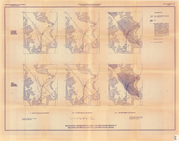
Maps showing distribution of coarse- and fine-grained deposits in the upper 1,000 feet of valley fill, Las Vegas Valley, Nevada, 1981 (Open-file report 84-130, plate 3)

Date

1981

Description

'United States Department of the Interior, Geological Survey. Open-file report 84-130, plate 3.' 'Prepared in cooperation with the Clark County Department of Comprehensive Planning.' 'Base from U.S. Geological Survey, 1:250,000, Las Vegas and Kingman, 1969.' 'Geology from Malmberg (1965); Longwell and others (1965); and J. R. Harrill, 1979. Lithology by R.W. Plume, 1981.' Contents: Coarse-grained deposits: 0-200 feet below land surface; 200-700 feet below land surface; 700-1,000 feet below land surface -- Fine-grained deposits: 0-200 feet below land surface; 200-700 feet below land surface; 700-1,000 feet below land surface. Scale [ca. 1:310,464. 1 in.=approx. 4.9 miles]. Series: Open-file report (Geological Survey (U.S.))84-130 Originally published as plate 3 of Ground-water conditions in Las Vegas Valley, Clark County, Nevada. Part I. Hydrogeologic framework / by Russell W. Plume, published by the U.S. Geological Survey in 1984 as Open-file report 84-130.

Image

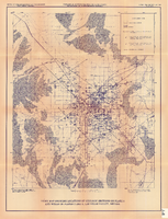
Index map showing locations of geologic sections on plate 2 and wells on plates 2 and 3, Las Vegas Valley, Nevada, 1981 (Open-file report 84-130)

Date

1981

Description

'United States Department of the Interior, Geological Survey. Open-file report 84-130, plate 4.' 'Prepared in cooperation with the Clark County Department of Comprehensive Planning.' 'Base from U.S. Geological Survey 1:100,000 , Boulder City, Ariz.-Nev., Las Vegas, Nev.-Calif., Mesquite Lake, Nev.-Calif., 1978, Lake Mead, Nev.-Ariz., 1979.' Geology from Malmberg (1965); Longwell and others (1965); Bell and Smith (1980); and J. R. Harrill, 1979.' Shows township and range lines. Scale [ca. 1:95.040. 1 in.=approx. 1.5 miles] (W 115°30´--W 115°00´/N 36°30´--N 36°00´). . Series: Open-file report (Geological Survey (U.S.))84-130. Originally published as plate 4 of Ground-water conditions in Las Vegas Valley, Clark County, Nevada. Part I. Hydrogeologic framework / by Russell W. Plume, published by the U.S. Geological Survey in 1984 as Open-file report 84-130.

Image