Search Results

Correspondence, Thomas Toland to Levi Syphus
Date
1925-03-06
Archival Collection
Description
This folder is from the "Correspondence" file of the Sadie and Hampton George Papers (MS-00434)
Text
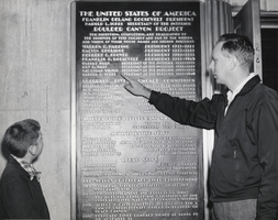
Photograph of Ray Lyman Wilbur II and Ray Lyman Wilbur III, Hoover Dam, circa 1950s
Date
1950 to 1959
Archival Collection
Description
The caption on the back of the image reads, " "Like grandfather, like father, like son" is an appropriate title for this photograph of Ray Lyman Wilbur II and Ray Lyman Wilbur III, reading the name of Ray Lyman Wilbur I on a bronze plaque at the Hoover Dam. As noted on the plaque, Ray Lyman Wilbur I was secretary of the Interior during President Hoover's administration and played a major role in administrative matters pertaining to the construction of Hoover Dam. His son and grandson, shown here, were visitors to the dam recently and were given a specially-conducted tour by the Bureau of Reclamation's guide service. The father and son reside at 1808 Indiana Street, Vallejo, California. The plaque is on the left hand side of the entrance to the Hoover Dam's Arizona elevator tower through which a third of a million visitors leave the dam and power plant each year following guided tours of this mammoth structure on the Colorado River between Nevada and Arizona. Guided tours of the dam and power plant, starting at the elevator tower on the Nevada side, are available daily to the public between the hours of 8 a.m. to 5 p.m. Ca. 1950's (Bureau of Reclamation photo)."
Image
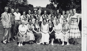
Photograph of Boulder City Elementary School teachers and faculty, Boulder City, Nevada, circa 1950s
Date
1950 to 1959
Archival Collection
Description
Group photograph of Boulder City (Nevada) Elementary School teachers and faculty. Front row, L-R: unknown woman, Emma Wood, Cecelia Thomas, Dorothy Johnson, Mabel Arnold, Edna French, Mae Hale. Second row: Nell Jones, Merle Lyon, Catherine Keese, Addie Heddens, Ada Robeson, Eileen Conners, Marian Sutherland, Paula Donlin. Third row: Andrew Mitchell, Lee Norman, Cal Smith, unknown woman, Evelyn Childress, unknown woman, Violet Muchow, Catherine Willis, Louise Newell, Marge Wallon, Virginia Arp, Thelma Parmelee, Neosha Norman, Rebecca Nalley.
Image
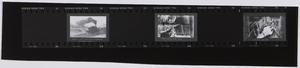
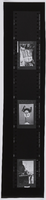
Film strip of Boulder City or Hoover Dam construction, image 004: photographic print
Date
1935-09-30
Archival Collection
Description
This photograph has three images. The first one, (0272_0014) reads, "Train load of gravel coming in three shay engines used for this load. Gravel comes from downstream of Boulder Canyon," as a handwritten inscription. The second one (0272_0015) that's upside down reads "March 9, 1934. New Union Pacific Train arrives at Boulder Dam." The third one (0272_0016) that's vertical shows the top workings on Boulder Dam from NV rim of Black Canyon (U.S. Bureau of Reclamation photo). It reads, "Top of dam about one form wide, everyone getting in each others way. '(0)' shows how much the slant of the dam has shortened the pours - form raisers have this one in place, waiting for carpenters to build the short side panels. (x) points out upstream face panels - form raisers nightmare, water soaked and patched up, very leery of climbing out, and straddling that lower 2x6 and start unbolting the panel. Notice the hand rails on other panels, but nothing to protect you from walking off the most thrilling fall of your life. Reeves often would (when we were safely out of sight, sitting astride a 2x6) he would sling out a bolt, and wait that long, long minute before it hit bottom. And say, 'Boy,' I'd hate to fall that far.' To be continued."
Image
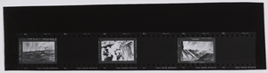
Film strip of Boulder City or Hoover Dam construction, image 008: photographic print
Date
1930 (year approximate) to 1939 (year approximate)
Archival Collection
Description
This photograph has three images. The first one, (0272_0035) shows people high scaling Boulder Dam. The handwritten inscription reads, "The Blackbirds drilling holes for blasting. High scalers, tough job. No chance to sleep here unless you want a long nap. 'Blackie', the graveyard shifter, tells me when he was working the drill from a bo'sn chair. He caught a man who had fallen out of his chair. Had a little too much of on the rocks. Some did fall without any help." The second image (0272_0036) shows the last big blast at Boulder Dam. (Provided by U.S. Bureau of Reclamation) It reads, "Blasting walls of canyon for keyway." The third one (0272_0037) is a picture of Coffer dam at Boulder Dam. The inscription reads, "Steel beams pile driven, rock filled and covered with reinforced concrete. Note size of trucks (at this time, largest in the world) in front of largest 'drilling jumbo' in the world also. There's six working levels on each side for men to work from, and is forty ft. long. About fifty men, each with a tender, works on this jumbo."
Image
Film strip of Boulder City or Hoover Dam construction, image 012: photographic print
Date
1930 (year approximate) to 1939 (year approximate)
Archival Collection
Description
This photograph has three images. The first one (0272_0056) reads, "See the river behind the dam. A heavy flow storming upriver, slot in middle of dam has gauges installed along to register heat generated by this pile of cement. Pipe strung along bottom of each pour on each level of the dam, ends in the slot. Each pipe at each level will be pumped with refrigerated water until each level has been cooled. Then the pipes will be pumped full of cement. They will then fill that 5 ft. height. If not cooled, would generate enough heat to explode." The second one (0272_0057) is upside-down, and it reads, "#8 hi-line with doors open; line is slack on doors. This line is called, by bell boy to operator, the load line. When full of mud this line carries the load. No.8 is now using single line, makes it faster and quieter." The third image (0272_0058) reads "No.8 and No.7 working off hi-trussel." The top arrow: hook tender, bottom arrow: donkey operator and his donkey - run by electricity." It also says, "No.8 using 4 yd. bucket to pour small forms on the face of the dam. Some forms become quite small as the slant of the dam shortens them at each height."
Image
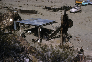
Slide of the old stamp mill, circa 1950s
Date
1950 to 1959
Archival Collection
Description
The old stamp mill, location unknown. A stamp mill (or stamp battery or stamping mill) is a type of mill machine that crushes material by pounding rather than grinding, either for further processing or for extraction of metallic ores. Breaking material down is a type of unit operation. A stamp mill consists of a set of heavy steel (iron-shod wood in some cases) stamps, loosely held vertically in a frame, in which the stamps can slide up and down. They are lifted by cams on a horizontal rotating shaft. On modern mills, the cam is arranged to lift the stamp from the side, so that it causes the stamp to rotate. This evens the wear on the shoe at the foot of the stamp. As the cam moves from under the stamp, the stamp falls onto the ore below, crushing the rock, and the lifting process is repeated at the next pass of the cam. Each one frame and stamp set is sometimes called a "battery" or, confusingly, a "stamp" and mills are sometimes categorized by how many stamps they have, i.e. a "10 stamp mill" has 10 sets. They usually are arranged linearly, but when a mill is enlarged, a new line of them may be constructed rather than extending the line. Abandoned mill sites (as documented by industrial archaeologists) will usually have linear rows of foundation sets as their most prominent visible feature as the overall apparatus can exceed 20 feet in height, requiring large foundations. Stamps are usually arranged in sets of five. Some ore processing applications used large quantities of water so some stamp mills are located near natural or artificial bodies of water. For example, the Redridge Steel Dam was built to supply stamp mills with process water.
Image
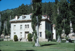
Slide of the Bowers Mansion, Washoe Valley, Nevada, circa 1970s
Date
1970 to 1979
Archival Collection
Description
The Bowers Mansion was built in 1863 by Lemuel "Sandy" Bowers and his wife, Eilley Orrum Bowers, and is a prime example of the homes built in Nevada by the new millionaires of the Comstock Lode mining boom. The mansion, designed by J. Neely Johnson, a builder and ex-governor of California, combined Georgian Revival and Italianate architectural styles. It was modeled after a design conceived by Eilley based on her recollection of elegant buildings in her native Scotland. Following the death of Sandy Bowers in 1868, Eilley fell on hard financial times. She generated income by renting out rooms in the mansion and hosting parties and picnics on the grounds. The mansion hosted a ball for the women's suffrage movement and was the location of the annual Miner's Ball. The period of 1873–75 was the height of the mansion's popularity. However, this was not enough to overcome Eilley's debts and she finally lost her home to foreclosure in 1876. The mansion was abandoned by the time Henry Riter acquired it and operated it as a resort until 1946. The building is currently owned and operated by the Washoe County Parks Department. Some 500 Nevada families have donated period furniture housed in the mansion. The park blends the historical site with recreational facilities such as a spring-fed swimming pool, picnic areas, and a playground. The Bowers Mansion is located in Washoe Valley, within the Bowers Mansion Regional Park at 4005 Old U.S. Highway 395 North, North Washoe Valley, Nevada.
Image
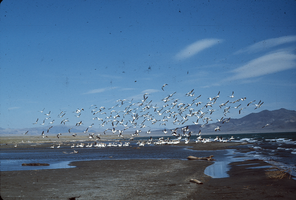
Slide of pelicans at Pyramid Lake, Nevada, circa 1970s
Date
1970 to 1979
Archival Collection
Description
A flock of pelicans at Pyramid Lake, Nevada. Some birds are wading near a sand bar, while others are airborne. Pyramid Lake is the geographic sink of the Truckee River Basin, 40 mi (64 km) northeast of Reno. Pyramid Lake is fed by the Truckee River, which is mostly the outflow from Lake Tahoe. The Truckee River enters Pyramid Lake at its southern end. Pyramid Lake has no outlet, with water leaving only by evaporation, or sub-surface seepage (an endorheic lake). The lake has about 10% of the area of the Great Salt Lake, but it has about 25% more volume. The salinity is approximately 1/6 that of sea water. Although clear Lake Tahoe forms the headwaters that drain to Pyramid Lake, the Truckee River delivers more turbid waters to Pyramid Lake after traversing the steep Sierra terrain and collecting moderately high silt-loaded surface runoff. Pyramid Lake is the site of some of the Earth's most spectacular tufa deposits. Tufa is a rock composed of calcium carbonate (CaCO3) that forms at the mouth of a spring, from lake water, or from a mixture of spring and lake water. The explorer John C. Fremont (1845) wrote about the tufas during his 1843-44 expedition and named the lake after the pyramidal-shaped island that lies along the east shore of the lake. The Paiute name for the island is Wono, meaning cone-shaped basket. The Paiute name for the lake is Cui-Ui Panunadu, meaning fish in standing water.
Image
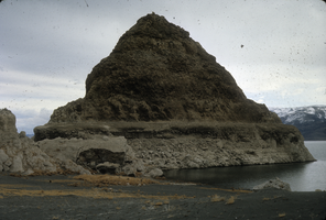
Slide of a tufa deposit in Pyramid Lake, Nevada, circa 1970s
Date
1970 to 1979
Archival Collection
Description
The pyramid-shaped island tufa that lies along the east shore of the lake and is the reason the lake was named Pyramid Lake. Pyramid Lake is the geographic sink of the Truckee River Basin, 40 mi (64 km) northeast of Reno. Pyramid Lake is fed by the Truckee River, which is mostly the outflow from Lake Tahoe. The Truckee River enters Pyramid Lake at its southern end. Pyramid Lake has no outlet, with water leaving only by evaporation, or sub-surface seepage (an endorheic lake). The lake has about 10% of the area of the Great Salt Lake, but it has about 25% more volume. The salinity is approximately 1/6 that of sea water. Although clear Lake Tahoe forms the headwaters that drain to Pyramid Lake, the Truckee River delivers more turbid waters to Pyramid Lake after traversing the steep Sierra terrain and collecting moderately high silt-loaded surface runoff. Pyramid Lake is the site of some of the Earth's most spectacular tufa deposits. Tufa is a rock composed of calcium carbonate (CaCO3) that forms at the mouth of a spring, from lake water, or from a mixture of spring and lake water. The explorer John C. Fremont (1845) wrote about the tufas during his 1843-44 expedition and named the lake after the pyramidal-shaped island that lies along the east shore of the lake. The Paiute name for the island is Wono, meaning cone-shaped basket. The Paiute name for the lake is Cui-Ui Panunadu, meaning fish in standing water.
Image