Search Results


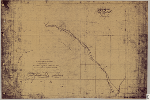
Map showing right of way of toll road constructed by Nevada Rapid Transit Co. in Lincoln County (Nev.), 1905
Date
1905
Description
Scale [ca. 126,720]. 1 in.=2 miles 1 map : blueline print ; 49 x 74 cmScale [ca. 126,720]. 1 in.=2 miles ; 1 map : blueline print ; 49 x 74 cm ; Shows right of way of what now is Interstate 95 through what is now Clark County, Nevada ; "Aug. 10, 1905." ; "Adopted as toll road of Nevada Rapid Transit Company at meeting of Board of Directors of said company Aug. 25, 1905. Attest Wh. Comstock, secretary, J. Ross Clark, president." ; "Book I, page 3"--Lower right corner of map ; "[Illegible] recording [illegible] J. Ross Clark September 1st. A.D. 1905 at 40 [illegible] 8 A in book of platts [illegible] Henry Lee [illegible]"--Upper right portion of map
Image
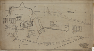
Map showing the proposed improvement of Las Vegas Springs, Las Vegas (Nev.), Clark County (Nev.), 1916
Date
1916
Description
Scale [ca. 1:240]. 1 in. to 20 feet. -- Scale [ca. 1:2,400]. 1 in. to 200 ft. Vertical scale [ca. 1:48]. 1 in. to 4 feet. -- Scale [ca. 1:4,800]. 1 in. to 100 feet ; 1 map : col. ; 40 x 78 cm ; "Scale as noted." ; "Exhibit 'A'." ; "Approved Sept. 21, 1916." ; "Div.Engr."--Lower right corner ; "W.E.J."--Lower left corner ; "L-44-50to61. T-75-17&46."--Upper left corner ; Includes discharge figures and plans for improvements to springs ; Library's copy has "Proposed layout" written on it in pencil ; Contents: Detail at springs -- Profile -- Alignment ;
Image