Search Results
Zero Lot Line Residences: Originals, 1982 September 16; 1983 August 09
Level of Description
Scope and Contents
This set includes: site plans, floor plans, redlining, preliminary sketches, exterior elevations, construction details, building sections, exterior perspectives and rendered exterior perspectives.
This set includes drawings for Nova Properties (client).
Archival Collection
Collection Name: Gary Guy Wilson Architectural Drawings
Box/Folder: Roll 317
Archival Component
Club Oasis Apartments: Temporary Office, 1987 May 1; 1988 January 28
Level of Description
Scope and Contents
This set includes: redlining, mechanical plans, electrical plans, plumbing plans, construction details, exterior elevations, floor plans, site plans and foundation plans.
This set includes drawings by Rosewood Enterprises, Inc (manufacturer).
Archival Collection
Collection Name: Gary Guy Wilson Architectural Drawings
Box/Folder: Roll 076
Archival Component
Booklet of construction progress photographs of the International Hotel, Las Vegas, February 1969
Date
Archival Collection
Description
Image
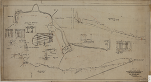
Map showing the proposed improvement of Las Vegas Springs, Las Vegas (Nev.), Clark County (Nev.), 1916
Date
Description
Scale [ca. 1:240]. 1 in. to 20 feet. -- Scale [ca. 1:2,400]. 1 in. to 200 ft. Vertical scale [ca. 1:48]. 1 in. to 4 feet. -- Scale [ca. 1:4,800]. 1 in. to 100 feet ; 1 map : col. ; 40 x 78 cm ; "Scale as noted." ; "Exhibit 'A'." ; "Approved Sept. 21, 1916." ; "Div.Engr."--Lower right corner ; "W.E.J."--Lower left corner ; "L-44-50to61. T-75-17&46."--Upper left corner ; Includes discharge figures and plans for improvements to springs ; Library's copy has "Proposed layout" written on it in pencil ; Contents: Detail at springs -- Profile -- Alignment ;
Image

Topographic map of Cane Spring, Nevada quadrangle, 1961
Date
Description
For sale by the U.S. Geological Survey
Image