Search Results
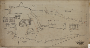
Map showing the proposed improvement of Las Vegas Springs, Las Vegas (Nev.), Clark County (Nev.), 1916
Date
1916
Description
Scale [ca. 1:240]. 1 in. to 20 feet. -- Scale [ca. 1:2,400]. 1 in. to 200 ft. Vertical scale [ca. 1:48]. 1 in. to 4 feet. -- Scale [ca. 1:4,800]. 1 in. to 100 feet ; 1 map : col. ; 40 x 78 cm ; "Scale as noted." ; "Exhibit 'A'." ; "Approved Sept. 21, 1916." ; "Div.Engr."--Lower right corner ; "W.E.J."--Lower left corner ; "L-44-50to61. T-75-17&46."--Upper left corner ; Includes discharge figures and plans for improvements to springs ; Library's copy has "Proposed layout" written on it in pencil ; Contents: Detail at springs -- Profile -- Alignment ;
Image

Topographic map of Cane Spring, Nevada quadrangle, 1961
Date
1961
Description
'Mapped, edited and published by the Geological Survey in cooperation with the Atomic Enegry Commission. Control by USGS, USC&GS, USCE, and Atomic Energy Commission. Topography from aerial photographs by photogrammetric methods. Aerial photographs taken 1959. Field check 1961.' Scale 1:24,000 polyconic projection (W 116°07'30"--W 116°00'00"/N 36°52'30"--N 36°45'00"). Series: 7.5 minute series (topographic). Relief shown by contours and spot heights. Contour interval 20 feet. Includes quadrangle location map. Interior--Geological SurveyFor sale by the U.S. Geological Survey
Image