Search Results
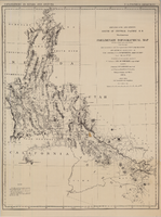
Map of explorations and surveys south of the Central Pacific Railroad made by the U.S. Army Corps of Topographical Engineers, 1871
Date
1871
Description
'Preliminary topographical map embracing in skeleton a portion only of the notes from surveys made in accordance with Par.II Special Orders No. 109 War Dept., March 18th, 1871 and letter of instructions of Brig. General A.A. Humphreys, Chief of Eng'rs. dated March 23rd, 1871. Conducted under the immediate direction of 1st Lieutenant Geo. M. Wheeler, Corps of Eng'rs., assisted by 1st Lieutenant D.W. Lockwood, Corps of Eng'rs. and 2nd Lieutentant D.A. Lyle, 2nd U.S. Artillery, during the summer and fall of 1871. Louis Nell, chief topographer and draughtsman.'' At head of map: 'Explorations in Nevada and Arizona. U.S. Engineer Department.' In lower left corner: 'Note: This map is a hasty and partial compilation from the topographical data already received, many still remaining en route. Upon it is projected in skeleton the groundwork of the area examined. All points except the prominent astronomical positiions are subject to lsight modification upon the final map.' Shows area through central Nevada, eastern California, and central Arizona. Relief shown by hachures. Published by the War Dept. Scale [ca. 1:1,520,640]. 1 in. to 24 miles (W 118°--W 109°/N 41°--N 32°).
Image

Map showing detailed topography of the country traversed by the reconnaissance expedition through southern & southeastern Nevada, 1869 (reproduction)
Date
1869
Description
At top of map: 'Reconnaissance Maps, Department of California.' 'In charge of, Lieut. Geo. M. Wheeler, U.S. Engineers; assisted by Lieut. D.W. Lockwood, Corps of Engineers,U.S.A., 1969.' 'P.W. Hamel, chief topographer and draugthsman.' 'Traced 11-13-67.' 'BGS'; the G is enclosed in an arrowhead shape. 'Officially compiled and published at the Engineer Office, Head Quarters Department of California in 1869 and 70 by order of Brigadier General E.O.C. Ord. Comm'dg. [signed] Geo. M. Wheeler, Lieutenant of Engineers In Charge, Head Quarters Dept. of Cal. Oct. 26th, 1870.' Includes information from railroad maps, the United States Geological Survey of the 40th parallel and from Lieutenant Ives' explorations along the Colorado. Map includes camps, astronomical stations, good and bad wagon roads, trails, springs, settlements, mining districts, state and county boundaries and the watershed between the Humboldt and Colorado Basin. Shows most of eastern half of Nevada. Relief shown by hachures and spot heights. Scale indeterminable. (W 117°00´--W 113°00´/N 41°45´--N 35°45´). Series: Reconnaissance maps. Military map / Department of Californiano. 1. Reproduction. Map is printed in purple. Scale of original map: [1:760,320]. 1 in. to approx. 12 miles. Includes dots hand-colored with red pencil marking Indian rancherias.
Image

Meeting minutes for Consolidated Student Senate, University of Nevada, Las Vegas, March 10, 2000
Date
2000-03-10
Archival Collection
Description
Includes meeting minutes and agenda. CSUN Session 30 (Part 1) Meeting Minutes and Agendas.
Text
Meeting minutes for Consolidated Student Senate, University of Nevada, Las Vegas, September 29, 2003
Date
2003-09-29
Archival Collection
Description
Includes meeting agenda, along with additional information about operating policies, bylaws, and contracts.
Text
Superior Court of California summons
Date
1938-01-05
Archival Collection
Description
This folder is from "Legal Records" file of the Sadie and Hampton George Papers (MS-00434)
Text

Meeting minutes for Consolidated Student Senate, University of Nevada, Las Vegas, December 06, 1999
Date
1999-12-06
Archival Collection
Description
Includes meeting minutes and agenda, along with additional information about CSUN cart procedures and proposals for funding. CSUN Session 30 (Part 1) Meeting Minutes and Agendas.
Text

Meeting minutes for Consolidated Student Senate University of Nevada, Las Vegas, Febraury 27, 1986
Date
1986-02-27
Archival Collection
Description
Includes meeting agenda and minutes along with additional information about bylaws.
Text