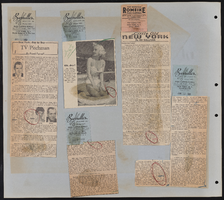
Search Results
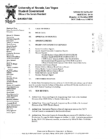
Meeting minutes for Consolidated Student Senate University of Nevada, Las Vegas, October 11, 1999
Date
1999-10-11
Archival Collection
Description
Includes meeting agenda and minutes, along with additional information about articles of impeachment.
Text
Meeting minutes for Consolidated Student Senate, University of Nevada, Las Vegas, January 24, 2005
Date
2005-01-24
Archival Collection
Description
Includes meeting minutes and agenda, along with additional information about bylaws and performance agreements.
Text
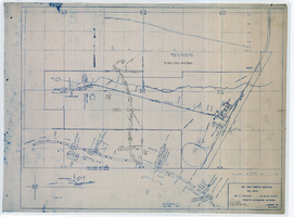
Map showing location of 24" C.I. pipeline in Las Vegas, Nevada, circa 1943
Date
1941 to 1945
Archival Collection
Description
Scale [ca. 1:120]. 1 in. to 10 feet.--Scale [ca. 1:1,200.] 1 in. to 100 feet.--Scale [ca. 1:7,200. 1 in.=approx. 600 feet] --Scale [ca. 1:7,200]. 1 in.=600 feet. Vertical scale [ca. 1:240]. 1 in.=20 feet. 1 map : blueline ; 58 x 74 cm. At head of title: As constructed drawing. "W.O.-8577." "Drawing no. 41092." "City of Las Vegas Highway transcribed from drwg. approved Harlan Brown, City Engineer-Sept. 1943-H.D.A 12/31/43"--Hand-written note. Map of the water pipes for Las Vegas. Includes the buildings in the railroad yard, a detailed map of a section of the pipe, a profile of the 24 inch C.I. pipe, and a map of the point of diversion. Date of detailed map is 5-20-1930. From the Union Pacific Railroad Collection. Los Angeles & Salt Lake Railroad Company, Office of Chief Engineer
Image
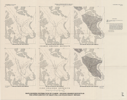
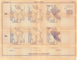
Maps showing distribution of coarse- and fine-grained deposits in the upper 1,000 feet of valley fill, Las Vegas Valley, Nevada, 1981 (Water-supply paper 2320-A, plate 3)
Date
1981
Description
'Department of Interior, U.S. Geological Survey. Water-supply paper 2320-A, plate 3.' 'Prepared in cooperation with the Clark County Department of Comprehensive Planning.' 'Base from U.S. Geological Survey, 1:250,000, Las Vegas and Kingman, 1969.' 'Geology from Malmberg (1965); Longwell and others (1965); and J. R. Harrill, 1976. Lithology by R.W. Plume, 1981.' Contents: Coarse-grained deposits: 0-200 feet below land surface; 200-700 feet below land surface; 700-1,000 feet below land surface -- Fine-grained deposits: 0-200 feet below land surface; 200-700 feet below land surface; 700-1,000 feet below land surface. Scale [ca. 1:316,800. 1 in.=approx. 5 miles]. Series: U.S. Geological Survey water-supply paper2320-A. Originally published as plate 3 of Ground-water conditions in Las Vegas Valley, Clark County, Nevada. Part I. Hydrogeologic framework / by Russell W. Plume, published by the U.S. Geological Survey in 1989 as Water-supply paper 2320-A.United States Dept. of the Interior, Geological Survey.
Image
Maps showing distribution of coarse- and fine-grained deposits in the upper 1,000 feet of valley fill, Las Vegas Valley, Nevada, 1981 (Open-file report 84-130, plate 3)
Date
1981
Description
'United States Department of the Interior, Geological Survey. Open-file report 84-130, plate 3.' 'Prepared in cooperation with the Clark County Department of Comprehensive Planning.' 'Base from U.S. Geological Survey, 1:250,000, Las Vegas and Kingman, 1969.' 'Geology from Malmberg (1965); Longwell and others (1965); and J. R. Harrill, 1979. Lithology by R.W. Plume, 1981.' Contents: Coarse-grained deposits: 0-200 feet below land surface; 200-700 feet below land surface; 700-1,000 feet below land surface -- Fine-grained deposits: 0-200 feet below land surface; 200-700 feet below land surface; 700-1,000 feet below land surface. Scale [ca. 1:310,464. 1 in.=approx. 4.9 miles]. Series: Open-file report (Geological Survey (U.S.))84-130 Originally published as plate 3 of Ground-water conditions in Las Vegas Valley, Clark County, Nevada. Part I. Hydrogeologic framework / by Russell W. Plume, published by the U.S. Geological Survey in 1984 as Open-file report 84-130.
Image
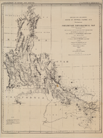
Map of explorations and surveys south of the Central Pacific Railroad made by the U.S. Army Corps of Topographical Engineers, 1871
Date
1871
Description
'Preliminary topographical map embracing in skeleton a portion only of the notes from surveys made in accordance with Par.II Special Orders No. 109 War Dept., March 18th, 1871 and letter of instructions of Brig. General A.A. Humphreys, Chief of Eng'rs. dated March 23rd, 1871. Conducted under the immediate direction of 1st Lieutenant Geo. M. Wheeler, Corps of Eng'rs., assisted by 1st Lieutenant D.W. Lockwood, Corps of Eng'rs. and 2nd Lieutentant D.A. Lyle, 2nd U.S. Artillery, during the summer and fall of 1871. Louis Nell, chief topographer and draughtsman.'' At head of map: 'Explorations in Nevada and Arizona. U.S. Engineer Department.' In lower left corner: 'Note: This map is a hasty and partial compilation from the topographical data already received, many still remaining en route. Upon it is projected in skeleton the groundwork of the area examined. All points except the prominent astronomical positiions are subject to lsight modification upon the final map.' Shows area through central Nevada, eastern California, and central Arizona. Relief shown by hachures. Published by the War Dept. Scale [ca. 1:1,520,640]. 1 in. to 24 miles (W 118°--W 109°/N 41°--N 32°).
Image