Search Results
The Wheel of Rotary Las Vegas Rotary Club newsletter, July 28, 1949
Date
1949-07-28
Archival Collection
Description
Newsletter issued by the Las Vegas Rotary Club
Text
The Wheel of Rotary Las Vegas Rotary Club newsletter, May 4, 1950
Date
1950-05-04
Archival Collection
Description
Newsletter issued by the Las Vegas Rotary Club
Text
The Wheel of Rotary Las Vegas Rotary Club newsletter, May 25, 1950
Date
1950-05-25
Archival Collection
Description
Newsletter issued by the Las Vegas Rotary Club
Text
The Wheel of Rotary Las Vegas Rotary Club newsletter, August 4, 1949
Date
1949-08-04
Archival Collection
Description
Newsletter issued by the Las Vegas Rotary Club
Text
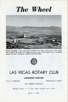
The Wheel Las Vegas Rotary Club newsletter, July 1, 1971
Date
1971-07-01
Archival Collection
Description
Newsletter issued by the Las Vegas Rotary Club
Text
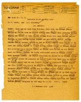
Coded telegram from W. H. Comstock to A. S. Halsted, August 15-16, 1922
Date
1922-08
Archival Collection
Description
Coded telegram from W. H. Comstock to A. S. Halsted, August 15-16, 1922
Text
Reports on the Hanson Assault, District Special Agent Harrington, August 15, 1922
Date
1922-09-15
Archival Collection
Description
Reports on the Hanson Assault, District Special Agent Harrington, August 15, 1922
Text
Telegram from Frank R. McNamee to C. P. Smith and A. S. Halsted, July 9, 1922
Date
1922-07-09
Archival Collection
Description
Telegram from Frank R. McNamee to C. P. Smith and A. S. Halsted, July 9, 1922
Text

Hydrogeologic map of Nevada Test Site and vicinity, southern Nevada, 1965
Date
1965
Description
At top of map: ' United States Department of the Interior, Geological Survey. Professional paper 712-C, plate 1. Prepared on behald of the U.S. Atomic Energy Commission.' At bottom of map: 'Base from U.S. Geological Survey, Caliente, Death Valley, Goldfield and Las Vegas, 1954. 100,00-foot grid based on Nevada coordinate system, central zone.' 'Hydrogeology by I. J. Winograd, 1965; geology by William Thordarson.' Relief shown by contours and spot heights. Shows township and range lines. Includes diagram of downward and upward cross-flow of water. Includes bibliographical references and index. Contour interval 200 feet. Scale 1:250,000 (W 117°--W 115°/N 38°--N 36°). Series: Professional paper (Geological Survey (U.S.), 712-C. Issued as plate 1 from Hydrogeologic and hydrochemical framework, south-central Great Basin, Nevada-California with special reference to the Nevada Test Site. Prepared on behalf of the U.S. Atomic Energy Commission by Isaac J. Winograd and William Thordarson. Published 1975 by U.S. Govt. Print. Off. in Washington.
Image